avia.wikisort.org - Aerodrome
Accomack County Airport (IATA: MFV, ICAO: KMFV, FAA LID: MFV) is a county-owned public-use airport located 1 mile (1.6 km) west of the central business district in Melfa, a town in Accomack County, Virginia, United States.[1]
Accomack County Airport | |||||||||||
|---|---|---|---|---|---|---|---|---|---|---|---|
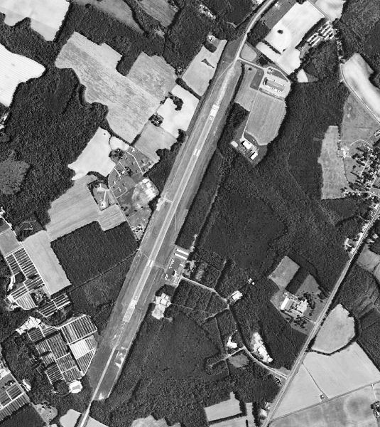 1995 USGS Photo | |||||||||||
| |||||||||||
| Summary | |||||||||||
| Airport type | Public | ||||||||||
| Owner | Accomack County Airport Commission | ||||||||||
| Location | Accomack County (near Melfa), Virginia, U.S. | ||||||||||
| Elevation AMSL | 47 ft / 14 m | ||||||||||
| Coordinates | 37°38′48″N 075°45′39″W | ||||||||||
| Map | |||||||||||
 MFV Location of airport in Virginia | |||||||||||
| Runways | |||||||||||
| |||||||||||
| Statistics (2008) | |||||||||||
| |||||||||||
Source: Federal Aviation Administration[1] | |||||||||||
History
The airport was built by the United States Army Air Forces about 1942, and was known as Melfa Flight Strip. It was an emergency landing airfield for military aircraft on training flights. It was closed after World War II, and was turned over for local government use by the War Assets Administration (WAA).[citation needed]
Between April 1957 and October 1958 the north end of runway 21, which is now a displaced threshold section, was used for tests by the Naval Ordnance Laboratory.
These tests involved an Vought F7U Cutlass dropping simulated atomic anti-runway bombs, to test for penetration necessary for effectiveness.[2]
The repairs to the displaced threshold, still visible on aerial photographs, are impacts from these tests.
Facilities and aircraft
Accomack County Airport covers an area of 100 acres which contains one runway designated 3/21 with a 5,000 x 100 ft (1,524 x 30 m) asphalt surface. For the 12-month period ending September 30, 2009, the airport had 14,056 aircraft operations, an average of 38 per day: 84% general aviation and 8% air taxi and 9% military. At that time there were 23 aircraft based at this airport: 22 single-engine and 1 multi-engine.[1]
References
- FAA Airport Form 5010 for MFV PDF, effective 2009-09-30
- "A History of Tonopah Test Range". OtherHand. Tom Mahood. Retrieved 2 February 2022.
![]() This article incorporates public domain material from the Air Force Historical Research Agency.
This article incorporates public domain material from the Air Force Historical Research Agency.
- Shaw, Frederick J. (2004), Locating Air Force Base Sites History's Legacy, Air Force History and Museums Program, United States Air Force, Washington DC, 2004.
External links
- Resources for this airport:
- FAA airport information for MFV
- AirNav airport information for MFV
- FlightAware airport information and live flight tracker
- SkyVector aeronautical chart for MFV
Другой контент может иметь иную лицензию. Перед использованием материалов сайта WikiSort.org внимательно изучите правила лицензирования конкретных элементов наполнения сайта.
WikiSort.org - проект по пересортировке и дополнению контента Википедии