avia.wikisort.org - Aerodrome
South Jersey Regional Airport (IATA: LLY, ICAO: KVAY, FAA LID: VAY, formerly 7MY) is a public use airport in Lumberton Township, Burlington County, New Jersey, United States. Owned by the New Jersey Department of Transportation, the airport is located four nautical miles (7 km) southwest of the central business district of Mount Holly, New Jersey.[1] This facility is included in the National Plan of Integrated Airport Systems for 2011–2015, which categorized it as a general aviation reliever airport.[2]
South Jersey Regional Airport | |||||||||||
|---|---|---|---|---|---|---|---|---|---|---|---|
| |||||||||||
| Summary | |||||||||||
| Airport type | Public | ||||||||||
| Owner | N.J. Dept. of Transportation | ||||||||||
| Serves | Mount Holly, New Jersey | ||||||||||
| Elevation AMSL | 53 ft / 16 m | ||||||||||
| Coordinates | 39°56′34″N 074°50′45″W | ||||||||||
| Map | |||||||||||
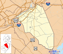 VAY Location in Burlington County / New Jersey / US  VAY VAY (New Jersey)  VAY VAY (the United States) | |||||||||||
| Runways | |||||||||||
| |||||||||||
| Statistics (2008) | |||||||||||
| |||||||||||
Source: Federal Aviation Administration[1] | |||||||||||
Although many U.S. airports use the same three-letter location identifier for the FAA and IATA, this airport is assigned VAY by the FAA[1] and LLY by the IATA.[3] The airport's ICAO identifier is KVAY.[4]
Facilities and aircraft
South Jersey Regional Airport covers an area of 642 acres (260 ha) at an elevation of 53 feet (16 m) above mean sea level. It has one runway designated 8/26 with an asphalt surface measuring 3,881 by 50 feet (1,183 x 15 m).[1]
For the 12-month period ending August 26, 2008, the airport had 31,234 aircraft operations, an average of 85 per day: 97% general aviation and 3% air taxi. At that time there were 92 aircraft based at this airport: 92% single-engine and 8% multi-engine.[1]
South Jersey Regional Airport is the headquarters for Beyond Aviation, a flight school and aircraft rental center based at the airport.[5]
See also
References
- FAA Airport Form 5010 for VAY PDF. Federal Aviation Administration. Effective November 15, 2012.
- "2011–2015 NPIAS Report, Appendix A" (PDF, 2.03 MB). National Plan of Integrated Airport Systems. Federal Aviation Administration. October 4, 2010.
- "IATA Airport Code Search (LLY: Mount Holly / Burlington County)". International Air Transport Association. Retrieved October 25, 2013.
- "VAY (KVAY) – SOUTH JERSEY RGNL". Federal Aviation Administration. Retrieved October 25, 2013.
- "Services – South Jersey Regional Airport".
External links
| Wikimedia Commons has media related to South Jersey Regional Airport. |
- Beyond Aviation
- South Jersey Regional Airport (VAY) from New Jersey DOT Airport Directory
- Aerial image as of March 1995 from USGS The National Map
- FAA Terminal Procedures for VAY, effective May 19, 2022
- Resources for this airport:
- FAA airport information for VAY
- AirNav airport information for KVAY
- ASN accident history for LLY
- FlightAware airport information and live flight tracker
- NOAA/NWS weather observations: current, past three days
- SkyVector aeronautical chart, Terminal Procedures
This article about an airport in New Jersey is a stub. You can help Wikipedia by expanding it. |
Другой контент может иметь иную лицензию. Перед использованием материалов сайта WikiSort.org внимательно изучите правила лицензирования конкретных элементов наполнения сайта.
WikiSort.org - проект по пересортировке и дополнению контента Википедии