avia.wikisort.org - Helicopter
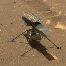
The NASA helicopter Ingenuity on Mars made the first powered controlled flights by an aircraft on a planet other than Earth.[1][2] Its first flight was April 19, 2021, after landing February 18 attached to the underside of the Perseverance rover.[3] Ingenuity weighs 1.8 kilograms (4.0 lb) and is 49 cm (19 in) tall. It is powered by six lithium-ion solar-charged batteries.[4] It was built and is operated by the Jet Propulsion Laboratory (JPL), a field center of NASA. It was designed for a 30-day demonstration period, but operated far above expectations and is still making flights more than a year after its first takeoff.
List of Ingenuity flights
Record values highlighted
| # | Date (UTC) | Duration (sec) | Altitude | Distance | Max Ground Speed | Route | Summary | |
|---|---|---|---|---|---|---|---|---|
| Technology Demonstration Phase | ||||||||
| 1 | April 19, 2021 at 07:34 (Sol 58) |
39.1 | 3 m (9.8 ft) | 0.05 m (0.16 ft)[5] | 0 m/s (0 mph) | Vertical takeoff, hover, land at Wright Brothers Field (JZRO) 18.44486°N 77.45102°E[6] | The first powered flight by any aircraft on another planet. While hovering, it rotated in place 96 degrees in a planned maneuver. Flight data was received at 11:30 UTC.[7][8] | |
| 2 | April 22, 2021 at 09:33 (Sol 61) |
51.9 | 5 m (16 ft) | 4 m (13 ft) Roundtrip | 0.5 m/s (1.1 mph) | Hover, shift westward 2 m (6.6 ft), hover, return, hover, land[9][10] 18.44486°N 77.45102°E[6] | From initial hover, it tilted 5 degrees, allowing rotors to fly it 2 meters sideways. It stopped, hovered in place, and rotated counterclockwise, yawing from +90° to 0° to -90° to -180°, in 3 steps, to point its color camera in various directions to take photos. It flew back to the takeoff location and landed.[11] | |
| 3 | April 25, 2021 at 11:31 (Sol 64) |
80.3 | 5 m (16 ft) | 99.97 m (328.0 ft) Roundtrip | 2 m/s (4.5 mph) | Hover, shift northward 49.98 m (164.0 ft), return, hover, land[12][13] 18.44486°N 77.45101°E[6] | First flight to venture some distance from the deployment spot. It flew downrange 50 meters at two meters per second, stopped, hovered, then returned and landed at the departure spot.[14] Data from the flight was received at 14:16 UTC.[13] | |
| Transition Phase | ||||||||
| 4 | April 29, 2021[15] (Sol 68) | First attempt of flight 4 failed; onboard software did not transition to flight mode.[16][17][18] | ||||||
| April 30, 2021 at 14:49[19] (Sol 69) |
116.9 | 5 m (16 ft) | 270.46 m (887.3 ft) Roundtrip | 3.5 m/s (7.8 mph) | Hover, shift southward 135.23 m (443.7 ft), hover, return, hover, land[20] 18.44486°N 77.45112°E[6] | Took color images while hovering at its farthest point from takeoff.[19] The Perseverance rover recorded both audio and video of Ingenuity in flight,[21] making the helicopter the first interplanetary vehicle whose sound was recorded off Earth. | ||
| 5 | May 7, 2021 at 19:26[22] (Sol 76) |
108.2 | 10 m (33 ft) | 130.84 m (429.3 ft) | 2 m/s (4.5 mph) | Hover, shift southwards 130.84 m (429.3 ft), climb to 10 m (33 ft), hover, land at Airfield B 18.44267°N 77.45139°E[6] | This was the first flight to land at a new location, 129 m (423 ft) to the south. Arriving above the destination, it gained altitude, hovered, captured color terrain images, then landed at the new site, Airfield B.[23][24] This flight was the last in the technology demonstration phase. | |
| Operation Demonstration Phase | ||||||||
| 6 | May 23, 2021 at 5:20[25] (Sol 91) |
139.9 | 10 m (33 ft) | 202.39 m (664.0 ft) with direction changes) | 4 m/s (8.9 mph) | Shift southwest about 140.9 m (462 ft), southward about 14.1 m (46 ft), northeast about 46.8 m (154 ft), land at Airfield C 18.44166°N 77.44994°E[6] | Near the end of the first leg of the route, a glitch occurred in the navigation images processing system. An image was dropped, and subsequent images with incorrect timestamps resulted in the craft tilting forward and backward up to 20 degrees, with large spikes in power consumption. It flew in that mode until successfully landing about 5 m (16 ft) away from the planned spot.[25][26]
This was the first time the helicopter had to land at an airfield which was not surveyed by any means other than MRO satellite imagery.[27][28] | |
| 6 | June 6, 2021[17] (Sol 105) | First attempt of flight 7 failed; onboard software did not transition to flight mode.[17] | ||||||
| June 8, 2021 at 15:54 (Sol 107) |
62.8[29] | 10 m (33 ft)[30] | 106.34 m (348.9 ft) | 4 m/s (8.9 mph) | Shift southward 106.3 m (349 ft) to land at Airfield D 18.43988°N 77.45015°E[6] | Flew to a new landing spot, Airfield D. The color camera was not used to prevent the glitch of flight 6 happening again.[31][32] | ||
| 8 | June 22, 2021 at 0:27[33] (Sol 121) |
77.4 | 10 m (33 ft) | 160.48 m (526.5 ft) | 4 m/s (8.9 mph) | Shift south south-east 160.48 m (526.5 ft) to land at Airfield E[17] 18.43724°N 77.45079°E[6] | The landing spot was about 133.5 m (438 ft) away from the Perseverance rover. As in the previous flight, the color camera was switched off, pending a software update.[17] | |
| 9 | July 5, 2021 at 9:03[30] (Sol 133) |
166.4 | 10 m (33 ft) | 631.78 m (2,072.8 ft) | 5 m/s (11 mph) | Shift southwest 631.79 m (2,070 ft) to Airfield F 18.42809°N 77.44545°E[6] | Flew southwest, over Séítah, a prospective research location in Jezero crater. This flight strained the navigation system, which by design assumes flat ground; Séítah has uneven sand dunes. Controllers had Ingenuity partly compensate by flying slower over the more challenging part of the route. Landing occurred 47 m (154 ft) from the center of the 50 m (160 ft) planned ellipse.[34][5][35][36] | |
| 10 | July 24, 2021 at 21:07[37] (Sol 152) |
165.4[38] | 12 m (39 ft) |
240.37 m (788.6 ft)[30] | 5 m/s (11 mph) | Loop south and west over prospective research location Raised Ridges to Airfield G 18.42808°N 77.44373°E[6] | The helicopter flew past 10 waypoints, including takeoff and landing.[39] | |
| # | Date (UTC) | Duration (sec) | Altitude | Distance | Max Ground Speed | Route | Summary | |
| 11 | August 5, 2021 at 4:53[40] (Sol 164) |
130.9 | 12 m (39 ft) | 388.29 m (1,273.9 ft) | 5 m/s (11 mph) | Shift northwest 388.29 m (1,273.9 ft) to land at Airfield H 18.43278°N 77.43919°E[6] | The flight positioned the craft for a route to take photographs of South Séítah.[40][41] | |
| 12 | August 16, 2021 at 12:57[42] (Sol 174) |
169.5 |
10 m (33 ft) | 448.21 m (1,470.5 ft) Roundtrip | 4.3 m/s (9.6 mph) | Takeoff and return to Airfield H again 18.43268°N 77.43924°E[6] | The return path was about 5 m (16 ft) to the side to allow another attempt to take paired images for stereo imagery. Landing was about 25 m (82 ft) east from the takeoff point.[43] | |
| 13 | September 5, 2021 at 00:10[44] (Sol 194) |
160.5 | 8 m (26 ft) | 209.4 m (687 ft) Roundtrip | 3.3 m/s (7.4 mph) | Takeoff and return to Airfield H again 18.43285°N 77.43915°E[6] | The flight northeast and back concentrated on one particular ridgeline and outcrops in South Séítah. | |
| 14 | September 18, 2021 (Sol 206) | A flight attempt at a faster rotor spin rate of 2700 rpm was automatically canceled due to a servo motor anomaly.[45] Three days earlier, September 15, Ingenuity successfully ground tested a rotor spin rate of 2800 rpm.[46] Servo motor "wiggle" tests were done on September 21 and 23 to diagnose the problem that prevented flight.[45][47] More ground tests and another flight attempt were postponed until after solar conjunction. Then, on October 21, NASA/JPL reported a successful 50 rpm ground test.[48] Ingenuity made its 14th flight three days later. | ||||||
| October 24, 2021 at 8:18 (Sol 241)[30] |
23.0 | 5 m (16 ft) | 2.18 m (7.2 ft) | 0.5 m/s (1.1 mph) | Hover, shift eastward 2.18 m (7.2 ft), hover, land again near Airfield H[45] 18.43284°N 77.43920°E[6] | The brief flight verified use of the faster rotor spin of 2700 rpm, needed during seasonal lower atmospheric density on Mars.[49][50] | ||
| 15 | November 6, 2021 at 16:22
(Sol 254) |
128.8 | 12 m (39 ft) | 410.27 m (1,346.0 ft) | 5 m/s (11 mph) | Shift southeast 411.3 m (1,349 ft) to land at Airfield F 18.42871°N 77.44501°E[6] | First in a series of four to seven flights on a return journey to Wright Brothers Field. This leg ended in the Raised Ridges region.[51][52] | |
| 16 | November 21, 2021 at 2:09[53]
(Sol 268) |
107.9 | 10 m (33 ft) | 116.99 m (383.8 ft) | 1.5 m/s (3.4 mph) | Shift northeast 116.99 m (383.8 ft) to land at Airfield J 18.43013°N 77.44645°E[6] | Landed near the edge of South Séítah, prior to crossing that area on multiple impending flights. | |
| 17 | December 5, 2021 at 12:25 (Sol 282) |
116.8 | 10 m (33 ft) | 187.36 m (614.7 ft) | 2.5 m/s (5.6 mph) | Shift northeast 187.7 m (616 ft) to land at Airfield K 18.43306°N 77.44771°E | Flew halfway across South Séítah along the heading of flight 9 but in the reverse direction.[54] The helicopter lost communication with the rover during final descent, roughly 3 m (10 ft) above the ground, but JPL believed the flight was a success, based on available telemetry. On Sol 285, Ingenuity relayed more information which suggested the helicopter was upright, based on the solar arrays charging the batteries, which could not be done if the helicopter fell sideways. JPL said local terrain and Perseverance positioning probably interrupted communication.[55] | |
| 18 | December 15, 2021 at 17:27[56][57] (Sol 292) |
124.3 | 10 m (33 ft) | 231.56 m (759.7 ft) | 2.5 m/s (5.6 mph) | Shift northeast 231.8 m (760 ft) to land near the northern edge of South Séítah at Airfield L18.43623°N 77.45011°E | Flew across South Séítah in the reverse of the flight 9 heading and landed near flight 9 takeoff spot. This was another in a series of flights returning Ingenuity to Wright Brothers Field. Airfield L has featureless sandy terrain, chosen for the lack of rocks for safe landing. The area is actually so devoid of rock that the helicopter sent warnings due to insufficient features for the vision navigation to track. JPL planned to update software fault protection parameters to reduce the risk of a premature landing on Flight 19. | |
| 19 | Between December 20, 2021 (Sol 297) and February 3 2022 (Sol 341) |
The first attempt of flight 19 was postponed due to a dust storm approaching Jezero Crater, the first time weather delayed a flight of an airborne vehicle on a celestial object other than Earth.[58] The storm reduced sunlight by 18 percent on Ingenuity's solar array, which charges its batteries, and warm dust lowered the surrounding air density by seven percent, which could have exceeded Ingenuity's ability to generate adequate lift. JPL waited over a month for the air to clear and the helicopter to regain its pre-storm power generating ability.[58][59] The storm deposited dust on the navigation camera window. To prevent navigation errors, JPL uploaded a new image mask file in late January that ignores certain regions of the image. Dust and sand also accumulated in all the swashplate assemblies. Repeated actuator self-tests and servo-wiggles cleared the debris. | ||||||
| February 8, 2022 at 04:21[60][59] (Sol 345) |
99.8 | 10 m (33 ft) | 61.19 m (200.8 ft) | 1 m/s (2.2 mph) | Shift northeast 61.6 m (202 ft) to land just above the eastern ridge of South Séítah at Airfield E 18.43700°N 77.45080°E | The helicopter flew out of South Séítah basin, across a dividing ridge and up to the main plateau, near the landing site of Flight 8. Images taken during Flight 9 were used to select a safe zone. The flight was another in a series to return to Wright Brothers Field. This gradual approach is due to lack of large landing sites in the area and lower atmospheric density in the summer, which requires higher rotor speeds and more power. The flight plan called for the helicopter to turn nearly 180 degrees before landing to aim its color camera toward the river delta for future flights. | ||
| 20 | February 25, 2022 at 13:35[61][62] (Sol 362) |
130.3 | 10 m (33 ft) | 392.27 m (1,287.0 ft) | 4.4 m/s (9.8 mph) | Shift northwest 392.27 m (1,287.0 ft) flying across Séítah to land at Airfield M 18.44337°N 77.44859°E | Ingenuity continued its journey back toward its original flight zone, landing just southwest of Wright Brothers Field. From there, it will take a shortcut to the Jezero Crater river delta, flying northwest across Séítah, while Perseverance drives around the region to the delta. | |
| # | Date (UTC) | Duration (sec) | Altitude | Distance | Max Ground Speed | Route | Summary | |
| 21 | March 10, 2022 at 22:10[63][64] (Sol 375) |
129.2 | 10 m (33 ft) | 374.4 m (1,228 ft) | 3.85 m/s (8.6 mph) | Shift northwest flying across Seìtah to land at Airfield N 18.44514°N 77.44219°E | First in a series of flights to a position near the base of the ancient river delta in Jezero Crater to scout ahead for Perseverance. | |
| 22 | March 20, 2022 at 4:06[65] (Sol 384) |
101.4 | 10 m (33 ft) | 70.4 m (231 ft) | 1 m/s (2.2 mph) | Shift northeast flying across northwest Seìtah to land again within Airfield N 18.44610°N 77.44292°E | Second flight toward position near base of the delta. Ingenuity flew only 70.4 m (231 ft), not the planned ~350 m (1,150 ft). | |
| 23 | March 24, 2022 at 6:44 [66] (Sol 388) |
129.1 | 10 m (33 ft) | 374.886 m (1,229.94 ft) | 4 m/s (8.9 mph) | Shift northeast and then northwest flying across Seìtah to land at Airfield P 18.44508°N 77.44345°E | Another flight on the way to a position near the base of the delta. The flight was complex, including a sharp turn to avoid a large hill. In deciding the remaining route to the delta, the mission team considered multiple factors: thermal (temperature of helicopter parts), atmospheric, flight time, navigation drift, landing site terrain, and keeping up with the rover.[67] | |
| 24 | April 3, 2022 at 12:49[67][5] (Sol 398) |
69.8 | 10 m (33 ft) | 47.54 m (156.0 ft) | 1.45 m/s (3.2 mph) | Shift northwest flying across Seìtah to land again at Airfield P 18.44508°N 77.44246°E | Fourth of five sorties crossing the Séítah region. Rotors spun at 2,537 rpm, a reduction from 2,700 rpm used since flight 14; this was a return to the slower rate of the earliest flights. Increasing air density allowed the reduction, as the thin air of the ending Martian summer was being replaced by fall's denser air. The short flight positioned Ingenuity for a long flight to approach its destination near the delta.[67] The date of flight 24 marked one year since Ingenuity's deployment to the surface from Perseverance. | |
| 25 | April 8, 2022 at 16:40[68] (Sol 403) |
161.3 | 10 m (33 ft) | 708.91 m (2,325.8 ft) |
5.50 m/s (12.3 mph) |
Shift northwest flying over Seìtah, land at staging area Airfield Q 18.45477°N 77.43058°E | Longest distance and highest speed of any flight so far. The mission team chose a route that avoided flying over hardware that was discarded and fell to the surface during the rover's entry-descent-landing (EDL) and might have caused unexpected performance from Ingenuity's laser altimeter and visual navigation system. This flight brought the helicopter out of the Séítah region.[67] | |
| 26 | April 19, 2022[69][70] at 1:32[71] (Sol 414) |
159.3 | 8 m (26 ft) | 391.18 m (1,283.4 ft) | 3.80 m/s (8.5 mph) | Shift southeast, southwest, and then northwest to land at Airfield R 18.45163°N 77.43046°E | Ingenuity flew closer to the delta and took color photos of the EDL debris, including the spacecraft backshell and parachute.[70] | |
| 27 | April 23, 2022 at 4:11[72][6] (Sol 418) |
153.25 | 10 m (33 ft) | 304.96 m (1,000.5 ft) | 3 m/s (6.7 mph) | Shift slightly southeast, then southwest, and then northwest to land at Airfield S 18.45252°N 77.42636°E | Ingenuity flew closer to the delta. | |
| 28 | April 29, 2022 at 7:44[73][6] (Sol 423) |
152.86 | 10 m (33 ft) | 420.94 m (1,381.0 ft) | 3.6 m/s (8.1 mph) | Shift northwest to land at Airfield T 18.45714°N 77.42068°E | Ingenuity flew closer to the delta. | |
Flight totals
![Tracks and locations of Perseverance and Ingenuity as of April 12, 2022[6]](http://upload.wikimedia.org/wikipedia/commons/thumb/a/ac/Mars_2020_Perseverance_Rover_Traverse_Path_And_Ingenuity_Helicopter_Flight_Path.png/440px-Mars_2020_Perseverance_Rover_Traverse_Path_And_Ingenuity_Helicopter_Flight_Path.png)
| Number of flights | Distance flown | Time flown | Sols since detached from rover on mission Sol 43, April 3, 2021 | ||
|---|---|---|---|---|---|
| 28 | 6.99 km (4.34 mi) | 54.26 min (3,256 s) | 405 | ||
| Sources: [30][5] | |||||
See also
- ARES – 2008 robotic Mars aircraft proposal
- Atmosphere of Mars
- Dragonfly – Robotic rotorcraft mission to Saturn's moon Titan, planned launch in 2027
- Exploration of Mars
- List of artificial objects on Mars
- List of firsts in aviation
References
Citations
- AFP Staff Writers (Apr 19, 2021). "Ingenuity helicopter successfully flew on Mars: NASA". Mars Daily. ScienceDaily. Retrieved 2021-04-19.
- Palca, Joe (19 April 2021). "Success! NASA's Ingenuity Makes First Powered Flight On Mars". National Public Radio. Retrieved 19 April 2021.
- Clarke, Stephen (14 May 2018). "Helicopter to accompany NASA's next Mars rover to Red Planet". Spaceflight Now. Retrieved May 10, 2022.
- "Ingenuity Mars Helicopter Landing Press Kit" (PDF). NASA. January 2021. Retrieved 14 February 2021.
- "m20_heli_waypoints". mars.nasa.gov. NASA. Retrieved 6 May 2022.
- mars.nasa.gov. "Location Map for Perseverance Rover". mars.nasa.gov. Retrieved 2022-05-05.
- "Success! NASA's Ingenuity Makes 1st Powered Flight On Mars". NPR.org. Retrieved 2022-05-05.
- Witze, Alexandra (April 19, 2021). "Lift off! First flight on Mars launches new way to explore worlds". Nature. Retrieved 20 April 2021.
- "Mars helicopter's first flight could happen on Monday". CNN.
Ingenuity could fly four days after the first flight, then three days after the second flight and so on.
- Status 294.
- "NASA's Ingenuity Mars Helicopter Logs Second Successful Flight". NASA's Mars Exploration Program. Retrieved 2021-04-25.
- Status 295.
- "NASA's Ingenuity Mars Helicopter Flies Faster, Farther on Third Flight". Jet Propulsion Laboratory. 25 April 2021. Retrieved 2021-04-25.
- Chang, Kenneth (25 April 2021). "'Nothing Short of Amazing': NASA Mars Helicopter Makes Longest Flight Yet - Ingenuity made a 328-foot round-trip journey, helping to demonstrate the capability of the vehicle's navigation system". The New York Times. Retrieved 26 April 2021.
- @NASAJPL (29 April 2021). "Aim high, and fly, fly again. The #MarsHelicopter's ambitious fourth flight didn't get off the ground, but the team…" (Tweet). Retrieved 2021-04-29 – via Twitter.
- Chang, Kenneth (2021-04-30). "NASA's Mars Helicopter Flies Again and Gets a New Mission". The New York Times. ISSN 0362-4331. Retrieved 2022-05-04.
- Status 308.
- Wall, Mike (29 April 2021). "Mars helicopter Ingenuity misses takeoff for 4th flight on Red Planet - NASA's team is assessing what happened". Space.com. Retrieved 29 April 2021.
- Status 297.
- "With Goals Met, NASA to Push Envelope With Ingenuity Mars Helicopter". Jet Propulsion Laboratory. 29 April 2021.
- "NASA's Perseverance Captures Video, Audio of Fourth Ingenuity Flight". NASA. 7 May 2021. Retrieved 7 May 2021.
- May 20218 (8 May 2021). "NASA's Mars helicopter Ingenuity lands at new airfield after 5th flight". Space.com. Retrieved 2021-05-09.
- NASA’s Ingenuity Mars Helicopter’s Next Steps (Media Briefing), retrieved 2022-05-04
- Chang, Kenneth (7 May 2021). "NASA Mars Helicopter Makes One-Way Flight to New Mission – Ingenuity has flown almost flawlessly through the red planet's thin air and will now assist the science mission of the Perseverance rover". The New York Times. Retrieved 9 May 2021.
- Status 305.
- Kooser, Amanda (May 27, 2021). "NASA Mars Ingenuity helicopter survives 'in-flight anomaly' on sixth flight". Cnet. Retrieved 2 June 2021.
- May 2021 (27 May 2021). "Mars helicopter Ingenuity experiences anomaly on 6th flight, but lands safely". Space.com. Retrieved 2021-06-10.
- Strickland, Ashley (May 28, 2021). "Mars helicopter survives to tell the tale of stressful flight". CNN. Retrieved 29 May 2021.
- @NASAJPL (8 June 2021). "Another successful flight 👏#MarsHelicopter completed its 7th flight and second within its operations demo phase. I…" (Tweet). Retrieved 2021-06-09 – via Twitter.
- "Flight Log". Mars Helicopter Tech Demo. NASA. Retrieved September 2, 2021.
- Status 306.
- Wall, Mike (9 June 2021). "Mars helicopter Ingenuity aces 7th flight on the Red Planet". Space.com. Retrieved 9 June 2021.
- @NASAJPL (22 June 2021). "Another successful flight for Ingenuity! The#MarsHelicopter completed its 8th flight on Monday. It flew for 77.4 s…" (Tweet). Retrieved 2021-06-22 – via Twitter.
- Status 313.
- @nasajpl (July 5, 2021). "MarsHelicopter pushes its Red Planet limits" (Tweet) – via Twitter.
- Status 314.
- Status 316.
- Malik, Tariq (26 July 2021). "NASA's Mars helicopter soars past 1-mile mark in 10th flight over Red Planet". Space.com.
- Bendix, Aria (July 24, 2021). "NASA's Mars helicopter nailed its 10th flight — double what engineers had hoped Ingenuity would do". Business Insider. Retrieved 25 July 2021.
- Status 318.
- @NASAJPL (5 August 2021). "#MarsHelicopter has safely flown to a new location! Ingenuity flew for 130.9 seconds and traveled about 380 meters…" (Tweet). Retrieved 2021-08-05 – via Twitter.
- Status 321.
- @JPL (August 17, 2021). "A dozen for the books!" (Tweet) – via Twitter.
- Status 329.
- Status 334.
- "rotor spin test at 2,800 rpm. Next up – flight 14". Twitter.
- Status 336.
- @NASAJPL (October 22, 2021). "Now that conjunction is over" (Tweet) – via Twitter.
- @NASAJPL (October 25, 2021). "Flight 14 completed" (Tweet) – via Twitter.
- Status 341.
- Status 343.
- @NASAJPL (November 8, 2021). "The #MarsHelicopter successfully completed its 15th flight" (Tweet) – via Twitter.
- Status 346.
- Status 349.
- Status 350.
- @NASAJPL (December 17, 2021). "The #MarsHelicopter keeps going, going, going!" (Tweet) – via Twitter.
- "Mars Helicopter". Mars Helicopter Tech Demo. NASA. Retrieved 18 December 2021.
- Bapst, Jonathan; Mischna, Michael (January 19, 2022). "Grounded: First Flight Delay Due to Inclement Weather on Another World". Mars Helicopter Tech Demo. NASA. Retrieved 20 January 2022.
- Wall, Mike (8 February 2022). "Mars helicopter Ingenuity aces 19th flight after historic Red Planet weather delay". Space.com. Retrieved 9 February 2022.
- Cacan, Martin (January 4, 2022). "Flight 19 - New Year, Same Ingenuity". Mars Helicopter Tech Demo. Retrieved 6 January 2022.
- mars.nasa.gov. "Dusty Flight 19 Completed and Looking Ahead to Flight 20". mars.nasa.gov. Retrieved 2022-02-25.
- @NASAJPL (26 February 2022). "Flight 20 was a success!" (Tweet). Retrieved 2022-02-27 – via Twitter.
- @NASAJPL (March 11, 2022). "MarsHelicopter can't be stopped!" (Tweet). Retrieved March 11, 2022 – via Twitter.
- Torbet, Georgina (March 12, 2022). "Mars helicopter Ingenuity powers through its 21st flight". digitaltrends. Retrieved 13 March 2022.
- @NASAJPL (March 21, 2022). "Over the weekend, the #MarsHelicopter took its 22nd flight" (Tweet). Retrieved 2022-03-21 – via Twitter.
- @NASAJPL (24 March 2022). "MarsHelicopter successfully completed its 23rd excursion" (Tweet). Retrieved 2022-03-24 – via Twitter.
- Morrell, Ben (April 5, 2022). "Balancing Risks in the 'Séítah' Region - Flight 24". Mars Helicopter Tech Demo. NASA. Retrieved 6 April 2022.
- mars.nasa.gov. "Images from the Mars Perseverance Rover". mars.nasa.gov. Retrieved 2022-04-09.
- Davis, Margaret (April 28, 2022). "NASA's Ingenuity Mars Helicopter Captures Image of Perseverance's Backshell and Parachute on Its 26th Flight". The Science Times. Retrieved 10 May 2022.
- Chang, Kenneth (27 April 2022). "NASA Sees 'Otherworldly' Wreckage on Mars With Ingenuity Helicopter - The debris was part of the equipment that helped the Perseverance mission safely land on the red planet in 2021". The New York Times. Retrieved 28 April 2022.
- @NASAJPL (April 20, 2022). "Ingenuity completed its 26th flight" (Tweet). Retrieved April 21, 2022 – via Twitter.
- "Mars Helicopter Sol 418: Navigation Camera". Mars 2020 Perseverance Rover. Retrieved 26 April 2022.
- mars.nasa.gov. "Images from the Mars Perseverance Rover". mars.nasa.gov. Retrieved 2022-05-03.
Status reports
- Bob Balaram (March 19, 2021). "How is the Weather on Mars?". Status #287. NASA/JPL. Retrieved July 25, 2021.
- Bob Balaram (April 2, 2021). "It's Cold on Mars". Status #288. NASA/JPL.
- "When Should Ingenuity Fly?". Status #289. NASA/JPL. April 8, 2021. Retrieved July 25, 2021.
- "Work Progresses Toward Ingenuity's First Flight on Mars". Status #290. NASA/JPL. April 12, 2021. Retrieved July 25, 2021.
- "Mars Helicopter Flight Delayed to No Earlier than April 14". Status #291. NASA/JPL. April 10, 2021. Retrieved July 25, 2021.
- Ingenuity Flight Team (April 16, 2021). "Working the Challenge: Two Paths to First Flight on Mars". Status #292. NASA/JPL. Retrieved July 25, 2021.
- MiMi Aung (April 17, 2021). "Why We Choose to Try Our First Helicopter Flight on Monday". Status #293. NASA/JPL. Retrieved July 25, 2021.
- MiMi Aung (April 21, 2021). "We're Getting Ready for Ingenuity's Second Flight". Status #294. NASA/JPL. Retrieved July 25, 2021.
- Håvard Grip (April 23, 2021). "We Are Prepping for Ingenuity's Third Flight Test". Status #295. NASA/JPL.
- "Mars Helicopter's Flight Four Rescheduled". Status #296. NASA/JPL. April 29, 2021. Retrieved July 25, 2021.
- MiMi Aung (April 30, 2021). "Ingenuity Completes Its Fourth Flight". Status #297. NASA/JPL. Retrieved July 25, 2021.
- Håvard Grip (April 30, 2021). "What We're Learning About Ingenuity's Flight Control and Aerodynamic Performance". Status #298. NASA/JPL. Retrieved July 25, 2021.
- Josh Ravich (May 6, 2021). "Why Ingenuity's Fifth Flight Will Be Different". Status #299. NASA/JPL. Retrieved July 25, 2021.
- Bob Balaram, Jeremy Tyler (May 10, 2021). "Keeping Our Feet Firmly on the Ground". Status #301. NASA/JPL. Retrieved July 25, 2021.
- "Plans Underway for Ingenuity's Sixth Flight". Status #302. NASA/JPL. May 19, 2021. Retrieved July 25, 2021.
- Håvard Grip (May 27, 2021). "Surviving an In-Flight Anomaly: What Happened on Ingenuity's Sixth Flight". Status #305. NASA/JPL. Retrieved July 25, 2021.
- "Ingenuity Flight 7 Preview". Status #306. NASA/JPL. June 4, 2021. Retrieved July 25, 2021.
- Teddy Tzanetos (June 25, 2021). "Flight 8 Success, Software Updates, and Next Steps". Status #308. NASA/JPL. Retrieved July 25, 2021.
- Håvard Grip & Bob Balaram (July 2, 2021). "We're Going Big for Flight 9". Status #313. NASA/JPL. Retrieved July 25, 2021.
- Håvard Grip and Ken Williford (July 7, 2021). "Flight 9 Was a Nail-Biter, but Ingenuity Came Through With Flying Colors". Status #314. NASA/JPL. Retrieved July 25, 2021.
- Teddy Tzanetos (July 23, 2021). "Aerial Scouting of 'Raised Ridges' for Ingenuity's Flight 10". Status #316. NASA/JPL. Retrieved July 25, 2021.
- Josh Ravich (August 4, 2021). "North-By-Northwest for Ingenuity's 11th Flight". Status #318. NASA/JPL. Retrieved August 5, 2021.
- Teddy Tzanetos (August 15, 2021). "Better By the Dozen – Ingenuity Takes on Flight 12". Status #321. NASA/JPL. Retrieved August 15, 2021.
- Teddy Tzanetos, Håvard Grip (September 3, 2021). "Lucky 13 – Ingenuity to Get Lower for More Detailed Images During Next Flight". Status #329. NASA/JPL. Retrieved September 3, 2021.
- Håvard Grip (September 15, 2021). "Flying on Mars Is Getting Harder and Harder". Status #334. NASA/JPL. Retrieved September 15, 2021.
- Jaakko Karras (September 28, 2021). "2,800 RPM Spin a Success, but Flight 14 Delayed to Post Conjunction". Status #336. NASA/JPL. Retrieved September 28, 2021.
- Teddy Tzanetos (October 10, 2021). "Flight 14 Successful". Status #341. NASA/JPL. Retrieved November 25, 2021.
- Teddy Tzanetos (November 5, 2021). "Flight #15 — Start of the Return Journey". Status #343. NASA/JPL. Retrieved November 25, 2021.
- Joshua Anderson (November 16, 2021). "Flight 16 — Short Hop to the North". Status #346. NASA/JPL. Retrieved November 25, 2021.
- Gerik Kubiak (December 2, 2021). "Flight 17 — Heading North Into Séítah". Status #349. NASA/JPL.
- Teddy Tzanetos (December 7, 2021). "Flight 17 – DiscoveringLimits". Status #350. NASA/JPL.
- Jaakko Karras (February 23, 2022). "Dusty Flight 19 Completed and Looking Ahead to Flight 20". Status #366. NASA/JPL. Retrieved February 27, 2022.
External links
- Mars Helicopter Technology Demonstrator. (PDF) – The key design features of the prototype drone.
- First Video of NASA's Ingenuity helicopter in flight – via YouTube.
- Perseverance Route Map — including the flight tracks of Ingenuity
- Explore Mars
Mars 2020 | |||||||
|---|---|---|---|---|---|---|---|
| |||||||
| Payloads |
|  | |||||
| Rover instruments |
| ||||||
| Features |
| ||||||
| Proposed landing sites |
| ||||||
| Related |
| ||||||
| |||||||
Spacecraft missions to Mars | ||||||||||
|---|---|---|---|---|---|---|---|---|---|---|
| ||||||||||
| Active |
|    | ||||||||
| Past |
| |||||||||
| ||||||||||
| Future |
| |||||||||
| ||||||||||
| Exploration |
| |||||||||
Missions are ordered by launch date. Sign † indicates failure en route or before intended mission data returned. | ||||||||||
NASA | |||||||
|---|---|---|---|---|---|---|---|
| Policy and history |
| ||||||
| Human spaceflight programs |
| ||||||
| Robotic programs |
| ||||||
| Individual featured missions (human and robotic) |
| ||||||
| Communications and navigation |
| ||||||
| NASA lists |
| ||||||
| NASA images and artwork |
| ||||||
| Related |
| ||||||
| |||||||
На других языках
- [en] List of flights by Ingenuity helicopter on Mars
[ru] Список полётов Ingenuity
Этот список включает перечень полётов марсианского вертолёта-разведчика Ingenuity — первого летательного аппарата с собственным двигателем, предназначенного для многократных полётов в атмосфере другого небесного тела.Текст в блоке "Читать" взят с сайта "Википедия" и доступен по лицензии Creative Commons Attribution-ShareAlike; в отдельных случаях могут действовать дополнительные условия.
Другой контент может иметь иную лицензию. Перед использованием материалов сайта WikiSort.org внимательно изучите правила лицензирования конкретных элементов наполнения сайта.
Другой контент может иметь иную лицензию. Перед использованием материалов сайта WikiSort.org внимательно изучите правила лицензирования конкретных элементов наполнения сайта.
2019-2025
WikiSort.org - проект по пересортировке и дополнению контента Википедии
WikiSort.org - проект по пересортировке и дополнению контента Википедии