avia.wikisort.org - Aerodrome
Annette Island Army Airfield is a closed United States Army airfield located on Annette Island in the Prince of Wales – Hyder Census Area of the U.S. state of Alaska. It is located 5 nautical miles (9 km) south of Metlakatla, Alaska.[1] After its closure, it was redeveloped into Annette Island Airport.
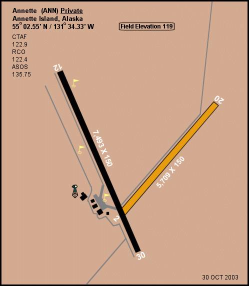
Annette Island Army Airfield | |||||||||||||||
|---|---|---|---|---|---|---|---|---|---|---|---|---|---|---|---|
 | |||||||||||||||
| Summary | |||||||||||||||
| Airport type | Military | ||||||||||||||
| Owner | United States Army | ||||||||||||||
| Serves | Metlakatla, Alaska | ||||||||||||||
| Location | Annette Island | ||||||||||||||
| Built | 1941 | ||||||||||||||
| Elevation AMSL | 119 ft / 36 m | ||||||||||||||
| Coordinates | 55°02′33″N 131°34′20″W | ||||||||||||||
| Map | |||||||||||||||
 Annette Island AAF Location of airport in Alaska | |||||||||||||||
| Runways | |||||||||||||||
| |||||||||||||||
See also
References
![]() This article incorporates public domain material from the Air Force Historical Research Agency website http://www.afhra.af.mil/.
This article incorporates public domain material from the Air Force Historical Research Agency website http://www.afhra.af.mil/.
- "Distance and heading from Metlakatla to ANN". Great Circle Mapper. Retrieved 5 August 2010.
Previously: Alaskan Air Force (1941-1942) | |||||||||
| Bases |
|  | |||||||
| Units |
| ||||||||
| |||||||||
This article about an Alaska airport is a stub. You can help Wikipedia by expanding it. |
This article about a location in the Prince of Wales–Hyder Census Area, Alaska is a stub. You can help Wikipedia by expanding it. |
Текст в блоке "Читать" взят с сайта "Википедия" и доступен по лицензии Creative Commons Attribution-ShareAlike; в отдельных случаях могут действовать дополнительные условия.
Другой контент может иметь иную лицензию. Перед использованием материалов сайта WikiSort.org внимательно изучите правила лицензирования конкретных элементов наполнения сайта.
Другой контент может иметь иную лицензию. Перед использованием материалов сайта WikiSort.org внимательно изучите правила лицензирования конкретных элементов наполнения сайта.
2019-2026
WikiSort.org - проект по пересортировке и дополнению контента Википедии
WikiSort.org - проект по пересортировке и дополнению контента Википедии