avia.wikisort.org - Aerodrome
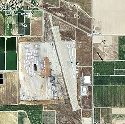
Haigh Field Airport (FAA LID: O37) is a public airport located three miles (4.8 km) southeast of the central business district (CBD) of Orland, a city in Glenn County, California, United States. It covers 300 acres (121 ha) and has one runway. It is mostly used for general aviation, and was used to train pilots during wartime.
Haigh Field Airport Orland Air Force Auxiliary Field | |||||||||||
|---|---|---|---|---|---|---|---|---|---|---|---|
 2006 USGS photo | |||||||||||
| |||||||||||
| Summary | |||||||||||
| Airport type | Public | ||||||||||
| Operator | Glenn County | ||||||||||
| Location | Orland, California | ||||||||||
| Elevation AMSL | 215 ft / 65.5 m | ||||||||||
| Coordinates | 39°43′16″N 122°08′48″W | ||||||||||
| Map | |||||||||||
 O37 Location of Haigh Field Airport | |||||||||||
| Runways | |||||||||||
| |||||||||||
World War II
During World War II, the airport was designated as Orland Air Force Auxiliary Field, and was an auxiliary training airfield for Chico Army Airfield, California.
See also
References
![]() This article incorporates public domain material from the Air Force Historical Research Agency website https://www.afhra.af.mil/.
This article incorporates public domain material from the Air Force Historical Research Agency website https://www.afhra.af.mil/.
External links
- Resources for this airport:
- FAA airport information for O37
- AirNav airport information for O37
- FlightAware airport information and live flight tracker
- SkyVector aeronautical chart for O37
Текст в блоке "Читать" взят с сайта "Википедия" и доступен по лицензии Creative Commons Attribution-ShareAlike; в отдельных случаях могут действовать дополнительные условия.
Другой контент может иметь иную лицензию. Перед использованием материалов сайта WikiSort.org внимательно изучите правила лицензирования конкретных элементов наполнения сайта.
Другой контент может иметь иную лицензию. Перед использованием материалов сайта WikiSort.org внимательно изучите правила лицензирования конкретных элементов наполнения сайта.
2019-2025
WikiSort.org - проект по пересортировке и дополнению контента Википедии
WikiSort.org - проект по пересортировке и дополнению контента Википедии
