avia.wikisort.org - Design
In oceanography, a gyre (/ˈdʒaɪər/) is any large system of circulating ocean currents, particularly those involved with large wind movements. Gyres are caused by the Coriolis effect; planetary vorticity, horizontal friction and vertical friction determine the circulatory patterns from the wind stress curl (torque).[1]
Gyre can refer to any type of vortex in an atmosphere or a sea,[2] even one that is human-created, but it is most commonly used in terrestrial oceanography to refer to the major ocean systems.
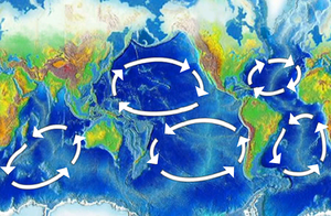
Major gyres
The following are the five most notable ocean gyres:[3]
- Indian Ocean Gyre
- North Atlantic Gyre
- North Pacific Gyre
- South Atlantic Gyre
- South Pacific Gyre
They flow clockwise in the Northern hemisphere, and counterclockwise in the Southern hemisphere.
Other gyres
Tropical gyres

Tropical gyres are less unified and tend to be mostly east–west with minor north–south extent.
- Atlantic Equatorial Current System (two counter-rotating circulations)[citation needed]
- Pacific Equatorial Current System[citation needed]
- Indian Monsoon Gyres (two counter-rotating circulations in northern Indian Ocean)[4]
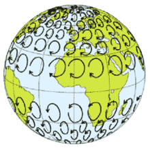
Subtropical gyres
The center of a subtropical gyre is a high pressure zone. Circulation around the high pressure is clockwise in the northern hemisphere and counterclockwise in the southern hemisphere, due to the Coriolis effect. The high pressure in the center is due to the westerly winds on the northern side of the gyre and easterly trade winds on the southern side. These cause frictional surface currents towards the latitude at the center of the gyre.
This build-up of water in the center creates flow towards the equator in the upper 1,000 to 2,000 m (3,300 to 6,600 ft) of the ocean, through rather complex dynamics. This flow is returned towards the pole in an intensified western boundary current. The boundary current of the North Atlantic Gyre is the Gulf Stream, of the North Pacific Gyre the Kuroshio Current, of the South Atlantic Gyre the Brazil Current, of the South Pacific Gyre the East Australian Current, and of the Indian Ocean Gyre the Agulhas Current.[citation needed]
Subpolar gyres
Subpolar gyres form at high latitudes (around 60°). Circulation of surface wind and ocean water is counterclockwise in the Northern Hemisphere, around a low-pressure area, such as the persistent Aleutian Low and the Icelandic Low. Surface currents generally move outward from the center of the system. This drives the Ekman transport, which creates an upwelling of nutrient-rich water from the lower depths.[5]
Subpolar circulation in the southern hemisphere is dominated by the Antarctic Circumpolar Current, due to the lack of large landmasses breaking up the Southern Ocean. There are minor gyres in the Weddell Sea and the Ross Sea, the Weddell Gyre and Ross Gyre, which circulate in a clockwise direction.[3]
Climate change
Ocean circulation re-distributes the heat and water-resources, therefore determines the regional climate. For example, the western branches of the subtropical gyres flow from the lower latitudes towards higher latitudes, bringing relatively warm and moist air to the adjacent land, contributing to a mild and wet climate (e.g., East China, Japan). In contrast, the eastern boundary currents of the subtropical gyres streaming from the higher latitudes towards lower latitudes, corresponding to a relatively cold and dry climate (e.g., California).
Currently, the core of the subtropical gyres are around 30° in both Hemispheres. However, their positions were not always there. Satellite observational sea surface height and sea surface temperature data suggest that the world's major ocean gyres are slowly moving towards higher latitudes in the past few decades. Such feature show agreement with climate model prediction under anthropogenic global warming.[6] Paleo-climate reconstruction also suggest that during the past cold climate intervals, i.e., ice ages, some of the western boundary currents (western branches of the subtropical ocean gyres) are closer to the equator than their modern positions.[7][8] These evidence implies that global warming is very likely to push the large-scale ocean gyres towards higher latitudes.[9][10]
The influence of the Coriolis effect on westward intensification
This section needs expansion. You can help by adding to it. (March 2018) |
Pollution
A garbage patch is a gyre of marine debris particles caused by the effects of ocean currents and increasing plastic pollution by human populations. These human-caused collections of plastic and other debris, cause ecosystem and environmental problems that affect marine life, contaminate oceans with toxic chemicals, and contribute to greenhouse gas emissions. Once waterborne, marine debris becomes mobile. Flotsam can be blown by the wind, or follow the flow of ocean currents, often ending up in the middle of oceanic gyres where currents are weakest. Garbage patches grow because of widespread loss of plastic from human trash collection systems.
The United Nations Environmental Program estimated that "for every square mile of ocean" there are about "46,000 pieces of plastic."[11] The 10 largest emitters of oceanic plastic pollution worldwide are, from the most to the least, China, Indonesia, Philippines, Vietnam, Sri Lanka, Thailand, Egypt, Malaysia, Nigeria, and Bangladesh,[12] largely through the rivers Yangtze, Indus, Yellow, Hai, Nile, Ganges, Pearl, Amur, Niger, and the Mekong, and accounting for "90 percent of all the plastic that reaches the world's oceans."[13][14] Asia was the leading source of mismanaged plastic waste, with China alone accounting for 2.4 million metric tons.[15]
The best known of these is the Great Pacific garbage patch which has the highest density of marine debris and plastic. Other identified patches include the North Atlantic garbage patch between North America and Africa, the South Atlantic garbage patch located between eastern South America and the tip of Africa, the South Pacific garbage patch located west of South America, and the Indian Ocean garbage patch found east of south Africa listed in order of decreasing size.[16] In the Pacific Gyre, specifically 20°N-40°N latitude, large bodies with floating marine debris can be found.[17] Models of wind patterns and ocean currents indicate that the plastic waste in the northern Pacific is particularly dense where the Subtropical Convergence Zone (STCZ), meets a southwest–northeast line, found north of the Hawaiian archipelago.[17]
In the Pacific, there are two mass buildups: the western garbage patch and the eastern garbage patch, the former off the coast of Japan and the latter between Hawaii and California. The two garbage patches are both part of the great Pacific garbage patch, and are connected through a section of plastic debris off the northern coast of the Hawaiian islands. These garbage patches contain 90 million tonnes (100 million short tons) of debris.[17] The waste is not compact, and although most of it is near the surface of the pacific, it can be found up to more than 30 metres (100 ft) deep in the water.[17]
2017 research [18] reported "the highest density of plastic rubbish anywhere in the world" on remote and uninhabited Henderson Island in South Pacific as a result of the South Pacific Gyre. The beaches contain an estimated 37.7 million items of debris together weighing 17.6 tonnes. In a study transect on North Beach, each day 17 to 268 new items washed up on a 10-metre section.[19][20][21]See also
- Anticyclone
- Cyclone
- Ecosystem of the North Pacific Subtropical Gyre
- Eddy
- Fluid dynamics
- Geostrophic current
- Skookumchuck
- Volta do mar
- Whirlpool
References
- Heinemann, B. and the Open University (1998) Ocean circulation, Oxford University Press: Page 98
- Lissauer, Jack J.; de Pater, Imke (2019). Fundamental Planetary Sciences : physics, chemistry, and habitability. New York: Cambridge University Press. ISBN 978-1108411981.
- The five most notable gyres Archived 2016-03-04 at the Wayback Machine PowerPoint Presentation
- "Indian Monsoon Gyres". Archived from the original on 2016-03-03. Retrieved 2008-04-15.
- Wind Driven Surface Currents: Gyres oceanmotion.org/html accessed 5 December 2021
- Poleward shift of the major ocean gyres detected in a warming climate. Geophysical Research Letters, 47, e2019GL085868 doi:10.1029/2019GL085868
- Bard, E., & Rickaby, R. E. (2009). Migration of the subtropical front as a modulator of glacial climate. Nature, 460(7253), 380.
- Wind-driven evolution of the north pacific subpolar gyre over the last deglaciation. Geophys. Res. Lett. 47, 208–212 (2020).
- Climate Change is Pushing Giant Ocean Currents Poleward Bob Berwyn, 26 February 2020 insideclimatenews.org, accessed 5 December 2021
- Major Ocean Currents Drifting Poleward www.loe.org, accessed 5 December 2021
- Maser, Chris (2014). Interactions of Land, Ocean and Humans: A Global Perspective. CRC Press. pp. 147–48. ISBN 978-1482226393.
- Jambeck, Jenna R.; Geyer, Roland; Wilcox, Chris (12 February 2015). "Plastic waste inputs from land into the ocean" (PDF). Science. 347 (6223): 769. Bibcode:2015Sci...347..768J. doi:10.1126/science.1260352. PMID 25678662. S2CID 206562155. Retrieved 28 August 2018.
- Christian Schmidt; Tobias Krauth; Stephan Wagner (11 October 2017). "Export of Plastic Debris by Rivers into the Sea" (PDF). Environmental Science & Technology. 51 (21): 12246–12253. Bibcode:2017EnST...5112246S. doi:10.1021/acs.est.7b02368. PMID 29019247.
The 10 top-ranked rivers transport 88–95% of the global load into the sea
- Harald Franzen (30 November 2017). "Almost all plastic in the ocean comes from just 10 rivers". Deutsche Welle. Retrieved 18 December 2018.
It turns out that about 90 percent of all the plastic that reaches the world's oceans gets flushed through just 10 rivers: The Yangtze, the Indus, Yellow River, Hai River, the Nile, the Ganges, Pearl River, Amur River, the Niger, and the Mekong (in that order).
- Robert Lee Hotz (13 February 2015). "Asia Leads World in Dumping Plastic in Seas". Wall Street Journal. Archived from the original on 23 February 2015.
- Cózar, Andrés; Echevarría, Fidel; González-Gordillo, J. Ignacio; Irigoien, Xabier; Úbeda, Bárbara; Hernández-León, Santiago; Palma, Álvaro T.; Navarro, Sandra; García-de-Lomas, Juan; Ruiz, Andrea; Fernández-de-Puelles, María L. (2014-07-15). "Plastic debris in the open ocean". Proceedings of the National Academy of Sciences. 111 (28): 10239–10244. Bibcode:2014PNAS..11110239C. doi:10.1073/pnas.1314705111. ISSN 0027-8424. PMC 4104848. PMID 24982135.
- "Marine Debris in the North Pacific A Summary of Existing Information and Identification of Data Gaps" (PDF). United States Environmental Protection Agency. 24 July 2015.
- Lavers, Jennifer L.; Bond, Alexander L. (2017). "Exceptional and rapid accumulation of anthropogenic debris on one of the world's most remote and pristine islands". Proceedings of the National Academy of Sciences. 114 (23): 6052–55. doi:10.1073/pnas.1619818114. PMC 5468685. PMID 28507128.
- Remote South Pacific island has highest levels of plastic rubbish in the world, Dani Cooper, ABC News Online, 16 May 2017
- Hunt, Elle (15 May 2017). "38 million pieces of plastic waste found on uninhabited South Pacific island". The Guardian. Retrieved 16 May 2017.
- "No one lives on this remote Pacific island – but it's covered in 38 million pieces of our trash". Washington Post. Retrieved 16 May 2017.
External links
- 5 Gyres – Understanding Plastic Marine Pollution
- Wind Driven Surface Currents: Gyres
- SIO 210: Introduction to Physical Oceanography – Global circulation
- SIO 210: Introduction to Physical Oceanography – Wind-forced circulation notes
- SIO 210: Introduction to Physical Oceanography – Lecture 6
- Physical Geography – Surface and Subsurface Ocean Currents
- North Pacific Gyre Oscillation — Georgia Institute of Technology
- Dunning, Brian (16 December 2008). "Skeptoid #132: The Sargasso Sea and the Pacific Garbage Patch". Skeptoid.
Ocean currents and gyres | |||||||||||
|---|---|---|---|---|---|---|---|---|---|---|---|
| Currents |
| ||||||||||
| Gyres |
| ||||||||||
| Related |
| ||||||||||
Physical oceanography | ||
|---|---|---|
| Waves |
|   |
| Circulation |
| |
| Tides |
| |
| Landforms |
| |
| Plate tectonics |
| |
| Ocean zones |
| |
| Sea level |
| |
| Acoustics |
| |
| Satellites | ||
| Related |
| |
| ||
Другой контент может иметь иную лицензию. Перед использованием материалов сайта WikiSort.org внимательно изучите правила лицензирования конкретных элементов наполнения сайта.
WikiSort.org - проект по пересортировке и дополнению контента Википедии