avia.wikisort.org - Event
The Mourne Mountains (/mɔːrn/ MORN; Irish: Beanna Boirche), also called the Mournes or Mountains of Mourne, are a granite mountain range in County Down in the south-east of Northern Ireland.[1] They include the highest mountains in Northern Ireland, the highest of which is Slieve Donard at 850 m (2,790 ft).[2] The Mournes are designated an Area of Outstanding Natural Beauty[3] and it has been proposed to make the area Northern Ireland's first national park.[4] The area is partly owned by the National Trust and sees many visitors every year.[5] The Mourne Wall crosses fifteen of the summits and was built to enclose the catchment basin of the Silent Valley and Ben Crom reservoirs.
This article needs additional citations for verification. (December 2017) |
| Mourne Mountains | |
|---|---|
| Beanna Boirche | |
 View of the Mournes from St John's Point, County Down | |
| Highest point | |
| Peak | Slieve Donard |
| Elevation | 850 m (2,790 ft) |
| Geography | |
  | |
| Sovereign state | United Kingdom |
| Constituent country | Northern Ireland |
| Counties | County Down |
| Range coordinates | 54°10′N 6°05′W |
| Geology | |
| Type of rock | Granite |
Mountains

The name 'Mourne' is derived from the name of a Gaelic clan or sept called the Múghdhorna.[6][7] The common Irish name for the mountains, na Beanna Boirche, may mean "the peaks of the peak district" or "peaks of Boirche" (a mythical king and cowherd).[8] It was historically anglicized as 'Bennyborfy'.[9]
Some of the mountains have names beginning "Slieve", such as Slieve Donard, Slieve Lamagan and Slieve Muck, which is derived from the Irish word sliabh, meaning "mountain".[10] There are also a number of curious names: Pigeon Rock; Buzzard's Roost; Brandy Pad; the Cock and Hen; Percy Bysshe; the Devil's Coach Road; and Pollaphuca[11] (from poll meaning "hole"[12] and púca meaning "ghost or spirit").[13]
On clear days, the Mourne Mountains can be seen from the Isle of Man[14] and Dublin.[15]
| Rank | Name | Irish name | Translation[lower-alpha 2] | Elevation[lower-alpha 3] | Prominence[lower-alpha 4] |
|---|---|---|---|---|---|
| 1 | Slieve Donard Highest in Ulster | Sliabh Dónairt | Domhanghart's mountain | 850 m (2,790 ft) | 822 m (2,697 ft) |
| 2 | Slieve Commedagh | Sliabh Coimhéideach | guarding/watching mountain | 767 m (2,516 ft) | 180 m (590 ft) |
| 3 | Slieve Binnian | Sliabh Binneáin | mountain of the little peaks | 746 m (2,448 ft) | 282 m (925 ft) |
| 4 | Slieve Bearnagh | Sliabh Bearnach | gapped mountain | 739 m (2,425 ft) | 304 m (997 ft) |
| 5 | Slieve Lamagan | Sliabh Lámhagáin | crawling/creeping mountain | 704 m (2,310 ft) | 197 m (646 ft) |
| 6 | Slieve Meelbeg | Sliabh Míol Beag | small mountain of the ants | 702 m (2,303 ft) | 193 m (633 ft) |
| 7 | Slieve Meelmore | Sliabh Míol Mór | great mountain of the ants | 680 m (2,230 ft) | 109 m (358 ft) |
| 8 | Slieve Muck | Sliabh Muc | pig mountain | 670 m (2,200 ft) | 155 m (509 ft) |
| 9 | Chimney Rock Mtn/Slieve Neir | Sliabh an Aoire | shepherd mountain | 656 m (2,152 ft) | 131 m (430 ft) |
| 10 | Cove Mountain | Unknown | Unknown | 655 m (2,149 ft) | 100 m (330 ft) |
| 11 | Slieve Corragh | Sliabh Corrach | rugged/pointed mountain | 640 m (2,100 ft) | 15 m (49 ft) |
| 12 | Eagle Mountain | Sliabh an Iolair | eagle mountain | 638 m (2,093 ft) | 263 m (863 ft) |
| 13 | Shanlieve | Seanshliabh | old mountain | 626 m (2,054 ft) | 31 m (102 ft) |
| 14 | Slieve Loughshannagh | Sliabh Loch Seannach | fox lake mountain | 617 m (2,024 ft) | 104 m (341 ft) |
| 15 | Slieve Beg | Sliabh Beag | little mountain | 596 m (1,955 ft) | 41 m (135 ft) |
| 16 | Doan | Dún Maol Chobha | Maol Cobha's fort | 593 m (1,946 ft) | 119 m (390 ft) |
| 17 | Slievenaglogh (Northern) | Sliabh na gCloch | mountain of the stones | 586 m (1,923 ft) | 41 m (135 ft) |
| 18 | Carn Mountain | Sliabh an Chairn | mountain of the cairn | 585 m (1,919 ft) | 50 m (160 ft) |
| 19 | Finlieve | Finnshliabh | white mountain[22] | 579 m (1,900 ft) | 20 m (66 ft) |
| 20 | Slievemoughanmore | Unknown | Unknown | 560 m (1,840 ft) | 154 m (505 ft) |
| 21 | Crossone | Cros Eoghain | Owen's cross[23] | 540 m (1,770 ft) | 12 m (39 ft) |
| 22 | Pigeon Rock Mtn/Drumlee | Droim Lao | ridge of the calf | 534 m (1,752 ft) | 139 m (456 ft) |
| 23 | Annalong Buttress | Unknown | Unknown | 530 m (1,740 ft) | Unknown |
| 24 | Ott Mountain | Ucht | mountain-breast | 527 m (1,729 ft) | 32 m (105 ft) |
| 25 | Ben Crom | Binn Chrom | stooped/curved peak | 526 m (1,726 ft) | 81 m (266 ft) |
| 26 | Rocky Mountain (Eastern) | Sliabh na gCloch | mountain of the stones | 524 m (1,719 ft) | 60 m (200 ft) |
| 27 | Blaeberry Mountain | Unknown | Unknown | 520 m (1,710 ft) | Unknown |
| 28 | Spences Mountain | Unknown | Unknown | 517 m (1,696 ft) | Unknown |
| 29 | Cock Mountain/Slievahilly | Sliabh an Choiligh | cock mountain | 504 m (1,654 ft) | 130 m (430 ft) |
| 30 | Butter Mountain | Sliabh an Ime | butter mountain | 500 m (1,600 ft) | 95 m (312 ft) |
| Lesser mountains and hills | |||||
| 31 | Slievemartin | Sliabh Mártain | Martin's mountain | 485 m (1,591 ft) | Unknown |
| 32 | Spaltha | Unknown | Unknown | 479 m (1,572 ft) | Unknown |
| 33 | Thomas Mountain | Unknown | Unknown | 475 m (1,558 ft) | Unknown |
| 34 | Tievedockdarragh | Taobh Docrach | difficult hillside | 473 m (1,552 ft) | Unknown |
| 35 | Spelga | Speilgeach | place of pointed rocks | 472 m (1,549 ft) | Unknown |
| 36 | Slievemeen | Sliabh Mín | smooth mountain | 471 m (1,545 ft) | Unknown |
| 37 | Pierces Castle | Unknown | Unknown | 465 m (1,526 ft) | Unknown |
| 38 | Crenville | Unknown | Unknown | 460 m (1,510 ft) | Unknown |
| 39 | Millstone Mountain | Unknown | Unknown | 459 m (1,506 ft) | Unknown |
| 40 | Wee Binnian | Broinn Bhinneáin | breast of (Slieve) Binnian | 459 m (1,506 ft) | Unknown |
| 41 | Slievenagarragh | Unknown | Unknown | 450 m (1,480 ft) | Unknown |
| 42 | Slievenamaddy | Sliabh na Madaidh | dog mountain[24] | 450 m (1,480 ft) | Unknown |
| 43 | Altaggart Mountain | Unknown | Unknown | 445 m (1,460 ft) | Unknown |
| 44 | Slievenaglogh (Southern) | Sliabh na gCloch | mountain of the stones | 445 m (1,460 ft) | Unknown |
| 45 | Slievenamiskan | Sliabh Meascáin | butter lump mountain | 444 m (1,457 ft) | Unknown |
| 46 | Slievenabrock | Sliabh na mBroc | badger mountain[25] | 438 m (1,437 ft) | Unknown |
| 47 | Hares Gap | Unknown | Unknown | 435 m (1,427 ft) | Unknown |
| 48 | Hares Castle | Unknown | Unknown | 430 m (1,410 ft) | Unknown |
| 49 | Wee Slievemoughan | Unknown | Unknown | 428 m (1,404 ft) | Unknown |
| 50 | Slievedermot | Sliabh Diarmuid | Dermot's mountain[26] | 425 m (1,394 ft) | Unknown |
| 51 | Slievemeel | Sliabh Maol | bald mountain | 420 m (1,380 ft) | Unknown |
| 52 | Leganabruchan | Unknown | Unknown | 410 m (1,350 ft) | Unknown |
| 53 | Craigdoo | Creag Dubh | black rock[27] | 408 m (1,339 ft) | Unknown |
| 54 | Rocky Mountain (Western) | Unknown | Unknown | 405 m (1,329 ft) | Unknown |
| 55 | Slieve Ban | Sliabh Bán | white mountain[28] | 395 m (1,296 ft) | Unknown |
| 56 | Windy Gap | Unknown | Unknown | 395 m (1,296 ft) | Unknown |
| 57 | Lukes Mountain | Unknown | Unknown | 391 m (1,283 ft) | Unknown |
| 58 | Slievebane | Unknown | Unknown | 390 m (1,280 ft) | Unknown |
| 59 | Tornamrock | Torr na mBroc | Torr of the Badgers | 390 m (1,280 ft) | Unknown |
| 60 | Slievenamuck | Unknown | Unknown | 390 m (1,280 ft) | Unknown |
| 61 | Gruggandoo | Unknown | Unknown | 380 m (1,250 ft) | Unknown |
| 62 | Black Stairs | Unknown | Unknown | 370 m (1,210 ft) | Unknown |
| 63 | Deers Meadow | Unknown | Unknown | 370 m (1,210 ft) | Unknown |
| 64 | Carnadranna | Unknown | Unknown | 365 m (1,198 ft) | Unknown |
| 65 | Slieve Roe | Sliabh Ruadh | red mountain[29] | 364 m (1,194 ft) | Unknown |
| 66 | Slieve Roosley | Unknown | Unknown | 362 m (1,188 ft) | Unknown |
| 67 | Hen Mountain/Slievenakirk | Sliabh na Circe[30] | hen mountain | 360 m (1,180 ft) | Unknown |
| 68 | Trainors Rocks | Unknown | Unknown | 360 m (1,180 ft) | Unknown |
| 69 | Lugagour | Unknown | Unknown | 360 m (1,180 ft) | Unknown |
| 70 | Leckan More | Unknown | Unknown | 355 m (1,165 ft) | Unknown |
| 71 | Percy Bysshe | Unknown | Unknown | 355 m (1,165 ft) | Unknown |
| 72 | Crannoge | Unknown | Unknown | 350 m (1,150 ft) | Unknown |
| 73 | The Fallow | Unknown | Unknown | 350 m (1,150 ft) | Unknown |
| 74 | Crotlieve | Crotshliabh | hump-mountain | 347 m (1,138 ft) | Unknown |
| 75 | Knockshee | Cnoc Sidhe | fairy hill[31] | 346 m (1,135 ft) | Unknown |
| 76 | Long Seefin | Suidhe Finn | Finn's seat[32] | 345 m (1,132 ft) | Unknown |
| 77 | Glen Fofanny | Unknown | Unknown | 340 m (1,120 ft) | Unknown |
| 78 | Slievenagore | Unknown | Unknown | 335 m (1,099 ft) | Unknown |
| 79 | Moolieve | Unknown | Unknown | 332 m (1,089 ft) | Unknown |
| 80 | Mullagharve | Unknown | Unknown | 330 m (1,080 ft) | Unknown |
| 81 | Slievenaman | Unknown | Unknown | 323 m (1,060 ft) | Unknown |
| 82 | Ardglash | Unknown | Unknown | 320 m (1,050 ft) | Unknown |
| 83 | Wee Roosley | Unknown | Unknown | 320 m (1,050 ft) | Unknown |
| 84 | Slievemageogh | Unknown | Unknown | 316 m (1,037 ft) | Unknown |
| 85 | Slievemiskan | Unknown | Unknown | 310 m (1,020 ft) | Unknown |
| 86 | Carmeen | Unknown | Unknown | 310 m (1,020 ft) | Unknown |
| 87 | Grugganskeagh | Unknown | Unknown | 310 m (1,020 ft) | Unknown |
| 88 | Knockchree | Unknown | Unknown | 305 m (1,001 ft) | Unknown |
| 89 | Ballyvally Mountain | Unknown | Unknown | 300 m (980 ft) | Unknown |
| 90 | Cloghmore Glen | Unknown | Unknown | 300 m (980 ft) | Unknown |
| 91 | Glenmore | Unknown | Unknown | 300 m (980 ft) | Unknown |
| 92 | The Creats | Unknown | Unknown | 300 m (980 ft) | Unknown |
| 93 | The Rowans | Unknown | Unknown | 300 m (980 ft) | Unknown |
Other features
The below sub-headings detail other features and visitor attractions found in the Mourne Mountains.
The Mourne Wall

The Mourne Wall is a dry stone wall measuring 31.4 km (19.5 miles) in length[33] that crosses fifteen summits and was constructed to define and protect the 36 km2 (8,900-acre) catchment area purchased by Belfast Water Commissioners in the late 19th century.[34] This followed a number of Acts of Parliament allowing the sale, and the establishment of a water supply from the Mournes to the growing industrial city of Belfast.[35] Construction of the Mourne Wall was started in 1904 and was completed in 1922.[34]
The Mourne Wall has been a listed building since 1996, and 600 repairs were completed in 2018 by Geda Construction.[36]
Forests

Tollymore Forest Park is at Bryansford, near the town of Newcastle in the Mourne and Slieve Croob Area of Outstanding Natural Beauty. It covers an area of 630 hectares (1,600 acres) at the foot of the Mourne Mountains and has views of the surrounding mountains and the sea at nearby Newcastle. The Shimna River flows through the park where it is crossed by 16 bridges, the earliest dating to 1726. The river is a spawning ground for salmon and trout and is an Area of Special Scientific Interest for its geology, flora and fauna. The forest has four walking trails signposted by different coloured arrows, the longest being the 8-mile (13 km) "long haul trail". The Forest Park has been managed by the Forest Service since they purchased it from the Roden Estate in 1941.
Donard Forest is near Newcastle, County Down. It borders Donard Park at the foot of the Mourne Mountains. The Glen River flows through the forest, crossed by three stone bridges.
Rostrevor Forest is near the village of Rostrevor, County Down, between the Mourne Mountains and Carlingford Lough, in the Mourne Area of Outstanding Natural Beauty. The first trees, primarily sitka spruce, douglas fir and pine, were planted in 1931.
Reservoirs

All water reservoirs are owned and maintained by Northern Ireland Water (NIW).
Silent Valley Reservoir is a reservoir in the Mourne Mountains near Kilkeel, County Down. It supplies most of the water for County Down, surrounding counties and most of Belfast via the Aquarius pipeline. The reservoir was built between 1923 and 1933 by a workforce of over one thousand men, nine of whom died during construction. The catchment area is 9,000-acres (3,600 ha / 36 km2).
Ben Crom Reservoir is upstream of Silent Valley in the Kilkeel River valley, and supplies the same areas. It was constructed between 1953 and 1957.
Spelga Reservoir is in the townland of Spelga (Irish: Speilgeach), close to Hilltown, in the North West of the Mourne Mountains. It was formed by construction of Spelga Dam and sits at over 1,200 ft (370 m) above sea level. The dam was constructed between 1953 and 1957, and has a volume of 2,700,000 cubic metres and a catchment area of 1,340-acres (542 ha / 5.423 km2).
Fofanny Dam Reservoir is approximately 2 km north-east of Spelga Dam and is much smaller.
Flora and fauna
Aside from grasses, the most common plants found in the Mournes are heathers and gorse. Of the former, three species are found: cross-leaved heath, bell heather, and common heather. Of the latter, two species are found: common gorse and western gorse. Other plants which grow in the area are: common cottongrass, roseroot, harebell, marsh St John's-wort, wild thyme, wood sorrel and heath spotted orchid.
Sheep graze high into the mountains, and the range is also home to birds, including the raven, peregrine falcon, wren, buzzard, meadow pipit, grey wagtail, stonechat and snipe. The golden eagle, a former inhabitant, has not been seen in the Mournes since 1836.
Recreation
"Discover Northern Ireland", a website operated by Tourism NI, promotes the Mourne Mountains as a popular destination for hiking and taking in views of the surrounding landscape, including local forests and the coastline.[37] The Mournes offer a range of activities for visitors, including hiking, forest and beach walks, cycling and rock climbing, with nearly three-quarters of visitors choosing the Mournes as a place to go walking and hiking.[38]
The Mournes are a popular destination for Duke of Edinburgh's Award expeditions.[39] However, there are also a number of walking challenges which take place in the Mournes. The Mourne Wall challenge, which is also referred to as the 7-peak challenge because it takes into account 7 of the 10 highest Mourne mountains, is advertised by WalkNI.[40] The Mourne six peak challenge is advertised by DiscoverNI and takes hikers up Slieve Donard, Commedagh, Bearnagh, Slieve Binnian, Slieve Meelmore and Slieve Meelbeg across three days of hiking.[41]
Information and statistics on tourism to the Mournes were gathered by TourismNI in 2014.[42] In a survey of leisure visitors, 79% were found to come from Northern Ireland, 15% from elsewhere in the British Isles or Republic of Ireland, and 5–6% were international visitors.[43] Two-thirds of all visitors made a single-day trip rather staying overnight, and party sizes averaged between 3 and 4 people.[44]
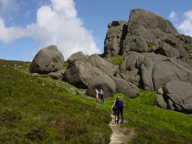
There are many granite cliffs, in the form of outcrops and tors, scattered throughout the range, making the Mournes one of Northern Ireland's major rock-climbing areas since the first recorded ascents in the 1930s. The rockforms are generally quite rounded, thus often requiring cams for protection, but with good friction. The 1998 guidebook lists 26 separate crags, with a total of about 900 routes of all grades.[45][46]
Conservation

Following a fundraising drive in 1993, the National Trust purchased nearly 5.3 km2 (1,300 acres) of land in the Mournes, which included a part of Slieve Donard (at 850 m (2,790 ft)) and nearby Slieve Commedagh (at 767 m (2,516 ft)), the second-highest mountain in the area.[47]
It has been proposed that the Mourne Mountains be made Northern Ireland's first national park.[48][49] The plan has been subject to controversy because of the area's status as private property, with over 1,000 farmers based in the proposed park,[49] and also because of fears over the impact on local communities, bureaucracy and house prices.[50]
Gorse burning
Historically, gorse had many uses in the rural economy[51] and hill farmers often cleared gorse by hand.[52] There is also a tradition in the Mournes of controlled gorse burning to improve grazing for sheep. Today, however, many of the fires are unmanaged and some become out-of-control wildfires.[53] In the 1950s, Emyr Estyn Evans had written that some shepherds in the Mournes tended to burn gorse and heather recklessly. He said that such over-burning "results in widespread destruction" and, along with other mismanagement, had "greatly impoverished the mountain environment".[54] In the 21st century there have been hundreds of heather and gorse wildfires in the Mournes each year, the vast majority started deliberately, with "farmers and vandals" often blamed.[55] It is claimed many of the wildfires are caused by hill farmers and landowners carrying out unapproved burning to clear gorse/heather and thus maximize the subsidy payments they receive for the amount of grazing-land they have.[51][53][56] Some are also caused by careless visitors.[56] In April 2021, more than a hundred firefighters tackled a major gorse wildfire in the eastern Mournes, which blazed for three days and devastated habitat in the area.[57][58] The over-clearing of gorse, heather and trees also heightens the risk of landslides.[52]
Wind farm proposal
In 2015, German-owned company ABO Wind applied to build a wind farm at Gruggandoo in the western Mourne Mountains. Its first two applications were turned down, and its revised application is to build eight turbines standing 142 metres (466 ft) high, along with a network of access tracks, substations and a control building. The turbines would be among the tallest structures in Ireland. The company claims they could power 37% of homes in the district. There is opposition, as the wind farm would be in an Area of Outstanding Natural Beauty and would impact wildlife and habitats. Local protest group, Mourne AONB Against Windfarms, warn it would open the door for further wind farms to be built in the Mournes and other protected areas.[59] Planning officers for Newry, Mourne and Down District Council deem the wind farm "unacceptable" and recommended the council reject it. In 2020, councillors instead voted to ask for a public inquiry.[60]
Popular culture
The mountains are immortalised in a song written by Percy French in 1896, "The Mountains of Mourne". The song has been recorded by many artists, including Don McLean, and was quoted in Irish group Thin Lizzy's 1979 song "Roisin Dubh (Black Rose): A Rock Legend". Frank Baker's famous Ulster-based comic novel Miss Hargreaves refers to it: "I’m not going to tell you much about the holiday except to say it was a grand month and we enjoyed every bit of it even though it rained much of the time. We went miles in the car, swam in the river, messed about in an old tub of a boat belonging to a farmer; and we spent a good many evenings in the hotel at Dungannon, drinking Irish whiskey and flirting with a cheeky girl Henry rather fell for. We climbed the Mourne Mountains and sang the right song on the top, though we couldn’t remember the words".
"The Mountains of Mourne" are also mentioned in John Lennon's song "The Luck of the Irish" on the album Some Time in New York City.[61]
The scenery of the Mourne Mountains have also provided the backdrop for a number of productions, most famously HBO's Game of Thrones.[62]
The Mourne Mountains also influenced C. S. Lewis to create the mythical world featured in his The Chronicles of Narnia series.[63][64]
Helicopter crash
On 23 October 2010 an AgustaWestland AW109 (tail number: N2NR) was operating a VFR flight from Enniskillen Airport to Caernarfon Airport, Wales. While en route the helicopter crashed into the western side of Shanlieve, killing all three passengers and crew on board. The cause of the accident was determined to be pilot error in heavy fog.[65]
See also
- List of mountains in Ireland
Notes
- MountainViews was created in 2002 by Simon Stewart as a non–profit online database for climbers in Ireland to document and catalogue their Irish climbs.[18] Its main data feed is taken from the Ordnance Survey Ireland ("OSI"). However, it also integrates other established Irish mountain databases such as the Paul Tempan Loganim Irish Placenames Database.[19] Collins Press published its Online Datase in 2013 in the book: A Guide to Ireland's Mountain Summits: The Vandeleur-Lynams & the Arderins.[20] MountainViews is also partnered with the important Database of British and Irish Hills ("DoBIH"), which is the main live database for the categorisation of mountains and hills in the British Isles.
- In all cases this is the "Name Origin and Meaning" column from Paul Tempan's Irish Hill and Mountain Names (2010).[17]
- 'Elevation' is the vertical height of the summit above average sea level.[21]
- 'Topographic prominence' is the height of the summit above the lowest point on the terrain surrounding it.[21]
References
- Pitfield, Mankelow, Cooper, Cameron, Lusty, Shaw, Linley (2012). County Down and Belfast: mineral resource map of Northern Ireland (PDF) (Map). Retrieved 14 October 2019.
{{cite map}}: CS1 maint: multiple names: authors list (link) - "Ireland's Range High Points". High Point Ireland. 2015.
- "Mourne Area of Outstanding Natural Beauty". NAAONB. 2019. Retrieved 14 October 2019.
- Mourne National Park Working Party (September 2007). Mourne National Park Working Party Report to Minister (Report). Retrieved 14 October 2019.
- "The Mournes". National Trust. 2019. Retrieved 14 October 2019.
- Joyce, Patrick (1869). The origin and history of Irish names of places. p. 128.
- "Placenames Database of Ireland". Logainm.ie. 13 December 2010. Retrieved 6 December 2011.
- Place Names NI: Mourne Mountains
- www.libraryireland.com https://www.libraryireland.com/articles/baronyiveaghjol/BaronyIveaghJOL.html.
{{cite web}}: Missing or empty|title=(help) - "Slieve definition of slieve by The Free Dictionary". The Free Dictionary. October 2019. Retrieved 15 October 2019.
- OSNI (24 June 2019). Ordnance Survey Map of the Mournes including Slieve Croob (Map). ISBN 1905306423.
- "poll - Irish English Dictionary". Irishionary. 2019. Retrieved 17 October 2019.
- "púca – Irish English Dictionary". Irishionary. 2019. Retrieved 17 October 2019.
- "Mourne Mountains from the Isle of Man". Andy Stephenson. 2010. Retrieved 23 January 2020.
- "View of Mourne Mountains over Dublin". gettyimages. Retrieved 22 January 2020.
- "Irish Highest 100: The highest 100 Irish mountains with a prominence of +100m". Mountainviews.ie. September 2018.
- Paul Tempan (February 2012). "Irish Hill and Mountain Names" (PDF). MountainViews.ie.
- "MountainViews.ie, a hillwalking resource for Ireland". Mountaineering Ireland (Irish Mountaineering Council). 2014.
- Simon Stewart (2018). "MountainViews Sources and Credits". MountainViews.ie.
- Mountainviews, (September 2013), "A Guide to Ireland's Mountain Summits: The Vandeleur-Lynams & the Arderins", Collins Books, Cork, ISBN 978-1-84889-164-7
- Svetlana Shele (18 August 2017). "On Terminology: Elevation vs. Altitue vs. Prominence". Retrieved 30 October 2019.
- Place Names NI: Finlieve
- Place Names NI: Crossone
- Place Names NI: Slievenamaddy
- Place Names NI: Slievenabrock
- Place Names NI: Slievedermot
- Place Names NI: Craigdoo
- Place Names NI: Slieve Ban
- Place Names NI: Slieve Roe
- Place Names NI: Hen Mountain
- Place Names NI: Knockshee
- Place Names NI: Long Seefin
- "Mourne Mountain Mythical Measurements (blog post by Kieron Gribbon)". 18 August 2019. Retrieved 18 August 2019.
- The Mourne Mountains (2010). "The Mourne Wall". Retrieved 22 January 2020.
- Belfast Plumbing Services (1 August 2016). "History of Belfast Water Supply". Retrieved 22 January 2020.
- "The Mourne Wall – NI Water's very own Wonderwall!". NI Water. 31 May 2019. Retrieved 22 January 2020.
- "Mourne Mountains". Retrieved 19 August 2019.
- "Destination Mournes" (PDF). TourismNI. 2014. Retrieved 17 October 2019.
- "Mournes Expedition Area Information" (PDF). The Duke of Edinburgh. February 2011. Retrieved 17 October 2019.
- "Mourne Wall Challenge". Outdoor Recreation Northern Ireland. 2019. Retrieved 17 October 2019.
- "Mourne six peak challenge". DiscoverNI. 2019. Retrieved 17 October 2019.
- "Destination Mournes" (PDF). TourismNI. 2014. Retrieved 17 October 2019.
- "Destination Mournes" (PDF). TourismNI. 2014. Retrieved 17 October 2019.
- "Destination Mournes" (PDF). TourismNI. 2014. Retrieved 17 October 2019.
- "Irish Climbing Online Wiki – Co. Down". Retrieved 7 April 2011.
- Robert Bankhead, ed. (1998), Mournes: MCI Guide, Mountaineering Ireland, ISBN 0-902940-14-7
- "The Mountains of Mourne". The Mourne Mountains. 2015. Retrieved 14 October 2019.
- "Minister paves the way for national park in the Mournes". Northern Ireland Planning Service. 25 September 2002. Retrieved 11 October 2009.
- Peterkin, Tom (29 August 2007). "Mourne Mountains national park status row". The Daily Telegraph. Archived from the original on 5 February 2011. Retrieved 11 October 2009.
- Cassidy, Martin (23 February 2007). "Community split over national park". BBC News. Retrieved 11 October 2009.
- Viney, Michael (13 May 2017). "The link between gorse fires, farming and a disregard for nature". The Irish Times.
- McKimm, Mike (5 May 2011). "Gorse fires in Northern Ireland damage environment". BBC News.
- "Response to Northern Ireland Environment Agency consultation on reducing wildfires in the countryside" (PDF). Mountaineering Ireland. 2018.
- Evans, Emyr Estyn (1951). Mourne Country: Landscape and Life in South Down. Dundalgan Press. p. 76.
- "Mourne Mountains: NIFRS records more than 1,000 wildfires since 2016". BBC News. 30 June 2021.
- "The Irish Times view on mountain fires: an ecological disaster". The Irish Times. 27 April 2021.
- "Slieve Donard: Over 100 firefighters continue to tackle Mournes 'major incident'". BBC News. 25 April 2021. Retrieved 26 April 2021.
- McClements, Freya (26 April 2021). "Northern Irish fire service believes Mourne Mountain blaze started deliberately". Irish Times. Retrieved 28 April 2021.
- "Council to consider Mourne wind turbines taller than London Eye". Belfast Telegraph, 26 October 2020.
- "Nichola Mallon asked to agree to inquiry into Mournes wind farm project". Belfast Telegraph, 27 October 2020.
- "The Luck of the Irish Lyrics and Guitar Chords". Irish Folk Songs. Retrieved 19 August 2019.
- "Game of Thrones Filming & Production". IMDb. Retrieved 19 August 2019.
- Guardian Staff (4 December 2005). "Northern Ireland: If you didn't find Narnia in your own wardrobe ..." The Observer. ISSN 0029-7712. Retrieved 24 October 2020.
- Inge, Sopphie (22 November 2016). "Winter snow blankets Mourne landscape that inspired Narnia as magical CS Lewis square opens in Belfast". belfasttelegraph. ISSN 0307-1235. Retrieved 24 October 2020.
- "Agusta A109A II, N2NR, 23 October 2010" (PDF). Retrieved 23 October 2010.
- Kirk, David (2002). The Mountains of Mourne: A Celebration of a Place Apart. Belfast: Appletree Press. ISBN 0-86281-846-X.
External links
- About the Mourne Mountains
- The website of the book above under 'References'
- A local family's site with some information about the mountains
- Mournes Climbers
- Photos, maps and commentary of the walk around the Mourne Wall
- BBC article about the Mourne Wall
Mountains and hills of Ulster | ||
|---|---|---|
| Antrim Hills |  | |
| Antrim Plateau | ||
| Belfast Hills | ||
| Croaghgorms | ||
| Derryveagh | ||
| Inishowen | ||
| Mournes | ||
| Sperrins | ||
| Southwest Donegal | ||
| Others | ||
Places in County Down | ||
|---|---|---|
List of places in County Down | ||
| Cities |  | |
| Towns | ||
| Villages and townlands |
| |
| Landforms |
| |
| Baronies |
| |
| ||
Authority control | |
|---|---|
| General |
|
| National libraries | |
На других языках
[de] Mourne Mountains
Die Mourne Mountains (auch Mountains of Mourne; irisch Na Beanna Boirche) sind ein aus Granit bestehender Gebirgszug rund 50 km südlich der nordirischen Hauptstadt Belfast zwischen Newry und Newcastle in der Baronie Mourne (irisch Múrna) im County Down gelegen. Bekanntester Gipfel ist der Slieve Donard, mit 849 Metern der höchste Berg Nordirlands. Die Gegend ist als sogenannte Area of Outstanding Natural Beauty klassifiziert, hier soll auch der erste Nationalpark Nordirlands entstehen.- [en] Mourne Mountains
[fr] Montagnes de Mourne
Les montagnes de Mourne (en anglais : Mourne Mountains ; en irlandais : Beanna Boirche) sont un massif montagneux granitique situé dans le nord-est de l'île d'Irlande, au sud-est de l'Irlande du Nord.[ru] Морн
Морн (англ. Mourne Mountains, ирл. Beanna Boirche, «холмы Борхе»[1]) — гранитная горная гряда в ольстерском графстве Даун на юго-востоке Северной Ирландии (Великобритания). Окружающая местность носит статус Area of Outstanding Natural Beauty, и была первой, предложенной в качестве национального парка Северной Ирландии[2][3] (хотя вокруг этого существуют споры из-за того, что здесь работает около тысячи фермеров[3], и это предложение в целом повлияет на местные общины, бюрократию и цены на жильё[4]).Другой контент может иметь иную лицензию. Перед использованием материалов сайта WikiSort.org внимательно изучите правила лицензирования конкретных элементов наполнения сайта.
WikiSort.org - проект по пересортировке и дополнению контента Википедии