avia.wikisort.org - Flugplatz
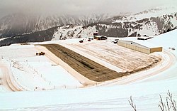
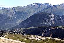
Der Flugplatz Courchevel ist ein französischer Flugplatz mitten im Skigebiet Courchevel auf einer Höhe von 2007 m (6600 ft). Er wird als Altiport bezeichnet.
| Flugplatz Courchevel Altiport de Courchevel | |
|---|---|
 | |
| Ansicht des Flugplatzes im Winter | |
| Kenndaten | |
| ICAO-Code | LFLJ |
| IATA-Code | CVF |
| Koordinaten | |
| Höhe über MSL | 2.007 m (6.585 ft) |
| Verkehrsanbindung | |
| Entfernung vom Stadtzentrum | 2 km südlich von Courchevel |
| Start- und Landebahn | |
| 04/22 | 537 m × 40 m Asphalt |
Die Landebahn ist nur 538 m lang und weist eine Steigung von bis zu 18,66 % auf. Für Piloten ist es somit nicht möglich, durchzustarten. Der Altiport gilt als einer der gefährlichsten Flugplätze der Welt.[1]
Für den Anflug ist eine eigene Qualification Montagne, d. h. eine Anflugerlaubnis für Altiports, oder eine sechs Monate gültige permission für diesen Flugplatz erforderlich.[2]
Der Flugplatz wurde früher auch von Linienflügen bedient, zuletzt etwa mit Dash-7-Turboprop-Flugzeugen der Linie Tyrolean Airways. Heute wird der Altiport von Hubschraubern und Sportflugzeugen benutzt. Als Rahmenprogramm zum alljährlichen Skisprung-Sommer-Grand-Prix in Courchevel nutzen Kunstflugstaffeln den Altiport als Stützpunkt.

Weblinks
Einzelnachweise
- Most Extreme Airports; Channel 5 (France); 14. Oktober 2010
- World's Most Dangerous Airports: Courchevel Airport auf: jaunted.com.
На других языках
- [de] Flugplatz Courchevel
[en] Courchevel Altiport
Courchevel Altiport (French: Altiport de Courchevel) (IATA: CVF, ICAO: LFLJ) is an altiport serving Courchevel, a ski resort in the French Alps. The airfield has a very short runway of only 537 metres (1,762 ft) with a gradient of 18.6%.[1] There is no go-around procedure for landings at Courchevel due to the surrounding mountainous terrain. The airfield primarily sees use by smaller fixed-wing aircraft such as the Cessna 208 Caravan, as well as helicopters. The runway has no instrument approach procedure or lighting aids, making landing in fog or low clouds unsafe and almost impossible.[1][fr] Altiport de Courchevel
L'altiport de Courchevel (code IATA : CVF • code OACI : LFLJ) est un altiport français situé sur la station de sports d'hiver de Courchevel 1850 (commune déléguée de Saint-Bon-Tarentaise) au sein du domaine skiable des 3 Vallées, dans le département de la Savoie en région Auvergne-Rhône-Alpes.[it] Aeroporto di Courchevel
L'aeroporto di Courchevel (in francese Altiport International de Courchevel), è un piccolo altiporto internazionale situato sulle Alpi francesi, nel dipartimento della Savoia, presso l'omonima località sciistica di Courchevel, compresa nel comune di Saint-Bon-Tarentaise e parte del comprensorio sciistico Les Trois Vallées.[2][ru] Куршевель (аэропорт)
Куршевель (фр. Aérodrome de Courchevel) — публичный аэропорт, обслуживающий французский курорт Куршевель. У аэропорта очень короткая взлётно-посадочная полоса, длиной 525 м с углом наклона 18.5 %. Ранее аэропорт обслуживался самолётами марок De Havilland Canada DHC-6 Twin Otter и De Havilland Canada Dash 7, а сейчас больше самолётов американского производителя Cessna и вертолёты. Взлётная полоса не обладает системой ILS, что ограничивает функциональность аэропорта при тумане.Другой контент может иметь иную лицензию. Перед использованием материалов сайта WikiSort.org внимательно изучите правила лицензирования конкретных элементов наполнения сайта.
WikiSort.org - проект по пересортировке и дополнению контента Википедии