avia.wikisort.org - Aerodrome
Goma International Airport (IATA: GOM, ICAO: FZNA) is an airport serving Goma, a city in the Democratic Republic of the Congo in Africa.
Goma Airport | |||||||||||
|---|---|---|---|---|---|---|---|---|---|---|---|
 Mount Nyiragongo at the background | |||||||||||
| |||||||||||
| Summary | |||||||||||
| Airport type | Public | ||||||||||
| Operator | Government | ||||||||||
| Location | Goma, Democratic Republic of the Congo | ||||||||||
| Elevation AMSL | 5,046 ft / 1,538 m | ||||||||||
| Coordinates | 01°40′15.08″S 29°14′18.25″E | ||||||||||
| Map | |||||||||||
 GOM Location of Goma International Airport in DRC | |||||||||||
| Runways | |||||||||||
| |||||||||||
Source: Regie des Voies Aériennes[1] ‡ Operable runway length per national aviation authority | |||||||||||
Airlines and destinations
| Airlines | Destinations |
|---|---|
| Compagnie Africaine d'Aviation | Beni, Bunia, Kavumu, Kindu, Kinshasa–N'djili, Kisangani |
| Congo Airways | Kindu, Kinshasa–N'djili,[2] Kisangani |
| Ethiopian Airlines | Addis Ababa[3] |
| Jambojet | Nairobi–Jomo Kenyatta[4] |
| RwandAir | Kigali[5] |
Military use
Goma International Airport is used by both the Air Force of the Democratic Republic of the Congo and MONUSCO peacekeeping forces.[6]
2002 Nyiragongo eruption in DRC
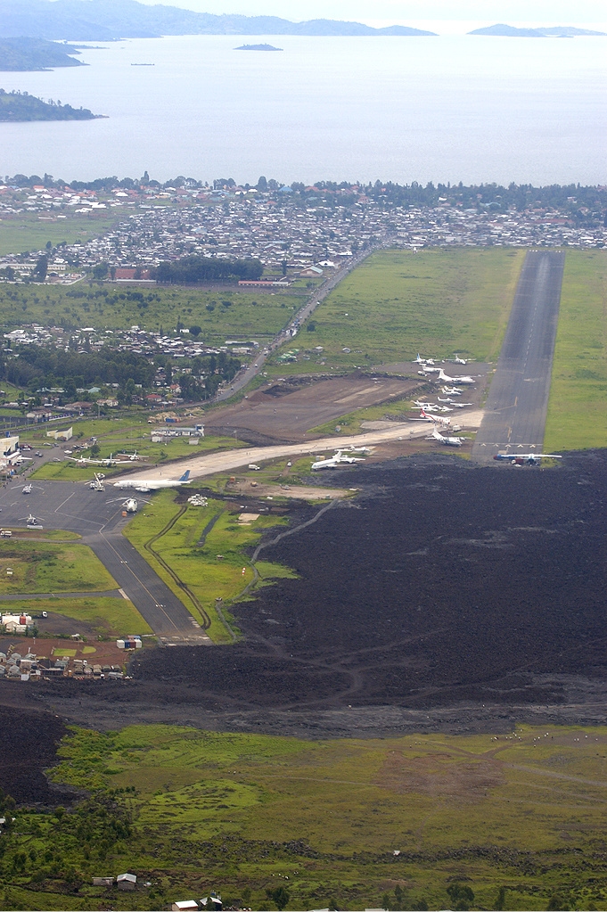
Initially built with a paved 3000 m runway and a large terminal and apron, the airport has not recovered from the 2002 eruption of the volcano Nyiragongo, 14 km to the north. The airport couldn't handle any wide-bodied aircraft except for freight operations run by relief agencies and the United Nations. A stream of fluid lava 200 m by 1000 m wide flowed onto the runway and through the city center as far as the lake shore, covering over the northern 1000 m of the runway and isolating the terminal and apron which were only connected by taxiway to the northern end. The lava can easily be seen in satellite photographs,[7] and aircraft can be seen using the 2000 m southern section of the runway which is clear of lava. A temporary apron was made at the side of the operational part of the runway. A Douglas DC-8 was left stranded on the terminal apron, which is now used by commercial passengers and the military. In December 2012, a contractor began work on cleaning up and fencing in the airport.[8] In February 2017, satellite imagery showed the runway has not yet been repaired where the lava damage occurred.[9]
2021 Nyiragongo eruption in DRC
News reports first indicated that lava from the 2021 Mount Nyiragongo eruption reached the airport.[10] It was later confirmed that the airport was unaffected.[11]
Accidents and incidents
- On 15 April 2008, 2008 Hewa Bora Airways crash, a Hewa Bora Airways McDonnell Douglas DC-9-51 (registration 9Q-CHN) overshot the runway during an aborted takeoff and crashed into the marketplace immediately to the south of the airport, killing 3 passengers and 37 people on ground.[12]
- On 19 November 2009, Compagnie Africaine d'Aviation Flight 3711, operated by McDonnell Douglas MD-82 (registration 9Q-CAB) bound from Kinshasa overran the runway on landing, suffering substantial damage.[13] The overrun area was contaminated by solidified lava.[14]
- On 4 March 2013, 2013 Compagnie Africaine d'Aviation crash, a Compagnie Africaine d'Aviation Fokker 50 (registration 9Q-CBD) from Lodja crashed short of landing in heavy rain, into a residential area at 17:55 local time.[15][16][17] Among the 9 crew and passengers, 6 were killed.
- On 24 November 2019, 2019 Busy Bee crash, a 19-seat airplane from local carrier Busy Bee en route to Beni Airport crashed shortly after takeoff around 9:10 a.m. At least 27 died, including some on the ground.[18]
See also
 Democratic Republic of the Congo portal
 Aviation portal
- Transport in the Democratic Republic of the Congo
- List of airports in the Democratic Republic of the Congo
 Media related to Goma Airport at Wikimedia Commons
References
- "Informations sur les 54 Aérports et Aérodromes Gérés par la RVA" [Information about the 54 Airports and Aerodromes operated by the RVA] (PDF) (in French). Regie des Voies Aériennes. 30 September 2009. p. 1. Archived from the original (PDF) on 26 October 2016. Retrieved 1 January 2017.
- HORAIRE AVEC 1 Q400 DU 06/06 AU 10/07/2016 (Heures locales), http://www.congoairways.com/wp-content/uploads/2015/11/HORAIRE-1-Q400-2016-V2.0-ok.pdf%5B%5D
- "Ethiopian Airlines Delays Goma Launch to August 2015". Airline Route. 17 July 2015. Retrieved 17 July 2015.
- "Jambojet destinations Goma". Jambojet. 3 September 2021. Retrieved 3 September 2021.
- "The Most Notable New Airline Routes This Week". 19 October 2021.
- Fittarelli, Alberto (26 June 2017). "The Strange Tale of the Georgians in Congo". bellingcat. Retrieved 26 June 2017.
However, a list published in October 2007 by the Dutch aviation magazine Scramble appears to show that on 19 July 2007, two Mi-24V helicopters with registration number 9T-HM11 and, more importantly, 9T-HM12 were registered, again by the FAC (here named "DR Congo Air Force"), as based at an airport with IATA code GOM – a.k.a. Goma International Airport [...] No evidence of affiliation with the MONUSCO operations under UNSC resolution 2098 was located, despite the pilots clearly operating from the same facilities – most notably, Goma International Airport.
- Google Earth has high resolution photographs showing the affected part of the airport at coordinates −1.658, 29.237. Retrieved 3 September 2007.
- "MONUSCO is building security fence around Goma airport" (Press release). MONUSCO. 12 January 2013. Retrieved 5 August 2016.
- HOTOSM Imagery, retrieved 14 March 2017
- "Volcano erupts in eastern Congo, thousands flee Goma". Reuters. 22 May 2021. Retrieved 23 May 2021.
- "DR Congo's Goma volcano: 'I couldn't save my sick husband from the lava'". BBC News. 24 May 2021. Retrieved 24 May 2021.
- "Accident description". Aviation Safety Network. Aviation Safety Network.
- David Kaminsky-Morrow (19 November 2009). "Congolese MD-82 badly damaged in Goma overrun". Flight Global.
- "Accident description". Aviation Safety Network. Retrieved 20 November 2009.
- "Dozens killed in DRC plane crash". News24. 4 March 2013.
- "RDC : un avion de la compagnie CAA s'est écrasé à Goma" (in French). Radio Okapi. 4 March 2013.
- "Plane crash in the city of Goma, MONUSCO comes to the rescue". MONUSCO. 5 March 2013. Retrieved 5 August 2016.
- "Plane Crash in Congo Kills at Least 27". The New York Times. 24 November 2019. Retrieved 24 November 2019.
External links
- Accident history for Goma International Airport at Aviation Safety Network
На других языках
[de] Flughafen Goma
Der Flughafen Goma (ICAO-Code: FZNA, IATA-Code: GOM) ist ein internationaler Flughafen[3] nahe der Stadt Goma in der Demokratischen Republik Kongo. Der Flughafen wurde 2002 beim Ausbruch des 14 Kilometer entfernten Nyiragongo von der Lava des Vulkans zerstört und danach mit internationaler Hilfe wieder aufgebaut.[4] Seitdem ist die Bahn von zuvor 3000 auf 2000 Meter verkürzt, was bereits zu mehreren Unfällen geführt hat.[5] Im Januar 2012 wurde der Flughafen bei einem weiteren Ausbruch erneut beschädigt.[6]- [en] Goma International Airport
[es] Aeropuerto de Goma
El Aeropuerto de Goma (IATA: GOM, OACI: FZNA) es un aeropuerto situado en Goma, una ciudad de la República Democrática del Congo, fronteriza con Ruanda.[fr] Aéroport international de Goma
L'aéroport international de Goma (code IATA : GOM • code OACI : FZNA) est l'unique aéroport de la ville de Goma dans l'est de la République démocratique du Congo. Il est situé dans la province de Nord-Kivu, en bordure du lac Kivu, à 14 kilomètres au sud du stratovolcan actif Nyiragongo et à proximité de la frontière avec le Rwanda. Il possède une piste unique de 3 000 m de long.Другой контент может иметь иную лицензию. Перед использованием материалов сайта WikiSort.org внимательно изучите правила лицензирования конкретных элементов наполнения сайта.
WikiSort.org - проект по пересортировке и дополнению контента Википедии