avia.wikisort.org - Aerodrome
This is a list of airports in Eswatini, sorted by location.
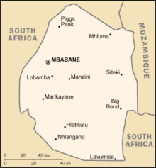
Eswatini is a landlocked country in southern Africa, bordered to the north, south and west by South Africa, and to the east by Mozambique. The nation, as well as its people, are named after the 19th-century king Mswati II. Eswatini is divided into four districts: Hhohho, Lubombo, Manzini, and Shiselweni. The capital of Eswatini is Mbabane, while the country's traditional and legislative capital is Lobamba.
Airports
Names shown in bold indicate the airport has scheduled passenger service on commercial airlines.
Most of the airfields listed below are unpaved. The exceptions are Matsapha Airport and Sikhuphe International Airport.
| Location served | ICAO | IATA | Airport name | Runway length/surface | Coordinates |
|---|---|---|---|---|---|
| Big Bend | FDBT | Tambuti Airfield | 800 m (2,600 ft) Grass | 26°44′10″S 31°46′35″E | |
| Big Bend | FDUB | Ubombo Ranches Airfield | 730 m (2,400 ft) unpaved | 26°46′07″S 031°56′12″E | |
| Bhunya | Bhunya Airfield | 1,250 m (4,100 ft) Gravel | 26°35′0″S 30°56′35″E | ||
| Kubuta | FDKS / FDKB | Kubuta Airfield | 847 m (2,779 ft) grass | 26°52′54″S 031°29′23″E[1] | |
| Manzini | FDMS | MTS | Matsapha (International) Airport | 2,600 m (8,500 ft) paved | 26°31′44″S 031°18′27″E |
| Manzini | FDSK | SHO | King Mswati III International Airport | 3,600 m (11,800 ft) Asphalt | 26°21′24″S 31°43′01″E |
| Mhlume | FDMH | Mhlume Airfield | 709 m (2,326 ft) unpaved | 26°01′33″S 031°48′36″E | |
| Ngonini | FDNG | Piggs Peak Airfield | 823 m (2,700 ft) unpaved | 25°47′53″S 031°24′43″E | |
| Nhlangano | FDNH | Nhlangano Airfield | 671 m (2,201 ft) unpaved | 27°07′12″S 031°12′45″E | |
| Nsoko | FDNS | Nsoko Airfield | 671 m (2,201 ft) unpaved | 27°01′06″S 031°56′07″E | |
| Simunye | FDSM | Simunye Airfield | 1,100 m (3,600 ft) unpaved | 26°11′46″S 031°55′48″E | |
| Siteki | FDST | Siteki Airfield | 1,006 m (3,301 ft) unpaved | 26°28′19″S 031°56′35″E | |
| Tambankulu | FDTM | Tambankulu Airfield | 875 m (2,871 ft) unpaved | 26°06′22″S 031°55′11″E | |
| Tshaneni | FDTS | Tshaneni Airfield | 756 m (2,480 ft) unpaved | 25°59′06″S 031°45′07″E |
The airstrip at Tshaneni is not to be confused with "Tshaneni Airport", a planned transportation hub based around the airstrip in Mkuze, a nearby town on the other side of the South African border.[citation needed]
See also
- King Mswati III International Airport (SHO)
- Transport in Eswatini
- List of airports by ICAO code: F#FD - Eswatini
- Wikipedia: WikiProject Aviation/Airline destination lists: Africa#Eswatini
References
- "ICAO Location Indicators by State" (XLSX). International Civil Aviation Organization. 2022-02-20.
- "Code for Trade and Transport Locations (UN/LOCODE) – (SZ) Eswatini". UN/LOCODE Code List by Country and Territory 2021-7. UNECE. July 2021. - includes IATA codes
- Great Circle Mapper: Airports in Eswatini - IATA and ICAO codes, coordinates
- King Mswati III. International Airport at Google maps
Eswatini articles | |||
|---|---|---|---|
| History |
|  | |
| Geography |
| ||
| Politics |
| ||
| Economy |
| ||
| Society |
| ||
| |||
На других языках
- [en] List of airports in Eswatini
[fr] Liste des aéroports en Eswatini
Voici une liste des aéroports d'Eswatini, triés par emplacement.Другой контент может иметь иную лицензию. Перед использованием материалов сайта WikiSort.org внимательно изучите правила лицензирования конкретных элементов наполнения сайта.
WikiSort.org - проект по пересортировке и дополнению контента Википедии