avia.wikisort.org - Aerodrome
This is a list of airports in Tunisia, sorted by location.
List


ICAO location identifiers link to airport page at Office de l'Aviation Civile et des Aeroports (OACA), the Tunisian Civil Aviation & Airports Authority.
Airport names shown in bold indicate the airport has scheduled service on commercial airlines.
| City | Governorate | ICAO | IATA | Airport name | Coordinates |
| Bizerte | Bizerte | DTTB | Bizerte-Sidi Ahmed Air Base (military) | 37°14′44″N 009°47′29″E | |
| Borj El Amri | Manouba | DTTI | Borj El Amri Airport | 36°43′16″N 009°56′35″E | |
| Djerba | Medenine | DTTJ | DJE | Djerba - Zarzis International Airport | 33°52′30″N 010°46′31″E |
| El Borma Oil Field | Tataouine | DTTR | EBM | El Borma Airport | 31°42′15″N 009°15′17″E |
| Enfidha | Sousse | DTNH | NBE | Enfidha – Hammamet International Airport | 36°05′31″N 010°24′50″E |
| Gabès | Gabès | DTTG | GAE | Gabès - Matmata International Airport (civil/military) | 33°44′0.13″N 9°55′5.55″E |
| Gafsa | Gafsa | DTTF | GAF | Gafsa - Ksar International Airport (civil/military) | 34°25′19″N 008°49′21″E |
| Kasserine | Kasserine | Thelepte Airfield | 35°00′15″N 008°35′37″E | ||
| Monastir | Monastir | DTMB | MIR | Monastir Habib Bourguiba International Airport | 35°45′29″N 010°45′17″E |
| Remada | Tataouine | DTTD | Remada Air Base (military) | 32°18′22″N 010°22′56″E | |
| Sfax | Sfax | DTTX | SFA | Sfax - Thyna International Airport | 34°43′04″N 010°41′27″E |
| Tabarka | Jendouba | DTKA | TBJ | Tabarka–Ain Draham International Airport | 36°58′48″N 008°52′37″E |
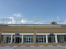
| Tozeur | Tozeur | DTTZ | TOE | Tozeur - Nefta International Airport | 33°56′23″N 008°06′38″E |
| Tunis | Tunis | DTTA | TUN | Tunis - Carthage International Airport | 36°51′04″N 10°13′38″E |
| Soliman | Nabeul | Soliman Airstrip | 36°42′31″N 010°26′56″E |
See also
- Transport in Tunisia
- Tunisian Air Force
- List of airports by ICAO code: D#DT - Tunisia
- Wikipedia:WikiProject Aviation/Airline destination lists: Africa#Tunisia
References
- Office de l'Aviation Civile et des Aeroports (OACA) at Tunisian Ministry of Transport
- "ICAO Location Indicators by State" (PDF). International Civil Aviation Organization. 2006-01-12.
- "UN Location Codes: Tunisia (includes IATA codes)". UN/LOCODE 2006-2. UNECE. 2007-04-30.
На других языках
[de] Liste der Flughäfen in Tunesien
Dies ist eine Liste der Zivilflughäfen in Tunesien, alphabetisch sortiert nach Orten:- [en] List of airports in Tunisia
[fr] Liste des aéroports en Tunisie
Le tableau ci-dessous fournit une liste des aéroports en Tunisie.[ru] Список аэропортов Туниса
Ниже приведён список аэропортов Туниса:Текст в блоке "Читать" взят с сайта "Википедия" и доступен по лицензии Creative Commons Attribution-ShareAlike; в отдельных случаях могут действовать дополнительные условия.
Другой контент может иметь иную лицензию. Перед использованием материалов сайта WikiSort.org внимательно изучите правила лицензирования конкретных элементов наполнения сайта.
Другой контент может иметь иную лицензию. Перед использованием материалов сайта WikiSort.org внимательно изучите правила лицензирования конкретных элементов наполнения сайта.
2019-2025
WikiSort.org - проект по пересортировке и дополнению контента Википедии
WikiSort.org - проект по пересортировке и дополнению контента Википедии