avia.wikisort.org - Aerodrome
This is a list of airports in Haiti, grouped by type and sorted by location.
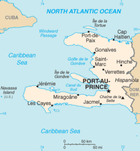
Haiti, officially the Republic of Haiti, is a Caribbean country. It occupies the western, smaller portion of the island of Hispaniola, which it shares with the Dominican Republic. The total area of Haiti is 27,750 square kilometres (10,714 sq mi). Its capital is Port-au-Prince. The official languages are French and Haitian Creole.
Haiti is divided into ten departments, which are further divided into 42 arrondissements, and 145 communes and 571 communal sections.
Airports
Airport names shown in bold indicate the airport has scheduled service on commercial airlines.
| City served | Department | ICAO | IATA | Airport name | Coordinates | Runway |
|---|---|---|---|---|---|---|
| International | ||||||
| Cap-Haïtien | Nord | MTCH | CAP | Cap-Haïtien International Airport | 19°43′59″N 72°11′41″W | 7,500 ft × 131 ft (2,286 m × 40 m) paved[1] |
| Port-au-Prince | Ouest | MTPP | PAP | Toussaint Louverture International Airport | 18°34′48″N 072°17′33″W | 9,974 ft × 141 ft (3,040 m × 43 m) paved[2] |
| Domestic | ||||||
| Hinche | Centre | HIN | Hinche Airport | 2,660 ft (810 m) unpaved | ||
| Jacmel | Sud-Est | MTJA | JAK | Jacmel Airport | 18°14′28″N 072°31′07″W | 3,937 ft × 95 ft (1,200 m × 29 m) paved[3] |
| Jérémie | Grand'Anse | MTJE | JEE | Jérémie Airport | 18°39′48″N 74°10′20″W | 3,937 ft (1,200 m) paved |
| Les Cayes | Sud | MTCA | CYA | Antoine-Simon Airport | 18°16′16″N 73°47′18″W | 3,666 ft × 80 ft (1,117 m × 24 m) paved[4] |
| Port-de-Paix | Nord-Ouest | MTPX | PAX | Port-de-Paix Airport | 19°56′05″N 72°50′50″W | 2,100 ft (640 m) unpaved |
| Other | ||||||
| Anse-à-Galets | Ouest | LGN | Anse-à-Galets Airport (on Île de la Gonâve) | 2,448 ft (746 m) unpaved | ||
| Anse-Rouge | Artibonite | Anse-Rouge Airport | 1,936 ft (590 m) unpaved | |||
| Belladère | Centre | Belladère Airport | 3,300 ft (1,000 m) unpaved | |||
| Dame-Marie | Grand'Anse | Dame-Marie Airport | 3,280 feet (1,000 m) grass | |||
| Fond-des-Blancs | Sud | Fond-des-Blancs Airport | 2,100 ft (640 m)unpaved | |||
| Môle-Saint-Nicolas | Nord-Ouest | Môle-Saint-Nicolas Airport | 3,150 ft (960 m) unpaved | |||
| Ouanaminthe | Nord-Est | OAN | Ouanaminthe Airport | 2,424 ft (739 m) unpaved | ||
| Phaeton | Nord-Est | FLT | Phaeton Airport | 3,238 ft (987 m) unpaved | ||
| Pignon | Nord | PGN | Pignon Airport | 3,500 ft (1,100 m) unpaved | ||
| Port-Salut | Sud | Port-Salut Airport | 2,628 ft (801 m) unpaved | |||
| Closed | ||||||
Airports by volume of traffic
- 1.) Toussaint Louverture International Airport Port au Prince
- 2.) Cap-Haïtien International Airport Cap-Haïtien
- 3.) Port-de-Paix Airport Port-de-Paix
- 4.) Antoine-Simon Airport Les Cayes
- 5.) Jérémie Airport Jérémie
Makeshift airstrips
In the wake of the 7.0 magnitude 2010 Haiti earthquake of January 12, several makeshift airports have been set up around the country to facilitate aid shipments.
Outside of Léogâne, a makeshift airstrip has been set up on part of Route 9, a highway of the commune, able to handle small planes.[5]
See also
- Transport in Haiti
- List of airports by ICAO code: M#MT - Haiti
- Wikipedia: WikiProject Aviation/Airline destination lists: North America#Haiti
References
- "ICAO Location Indicators by State" (PDF). International Civil Aviation Organization. 12 January 2006.
- "UN Location Codes: Dominican Republic (includes IATA codes)". UN/LOCODE 2011-1. UNECE. August 2011.
- UNJLC: Haiti Airfields
Footnotes
- World Aero Data: Cap-Haitien (MTCH). Accessed 5 February 2010.
- World Aero Data: Port-au-Prince (MTPP). Accessed 5 February 2010.
- World Aero Data: Jacmel (MTJA). Accessed 5 February 2010.
- World Aero Data: Les Cayes (MTCA). Accessed 5 February 2010.
- Shaila Dewan (4 February 2010). "Volunteers Fly Supplies Into Hard-to-Reach Areas". New York Times. Retrieved 4 February 2010.
External links
- Lists of airports in Haiti:
Airports in Haiti | |
|---|---|
| International | |
| Domestic | |
| Unscheduled | |
На других языках
- [en] List of airports in Haiti
[fr] Liste des aéroports en Haïti
Le pays possède six aéroports principaux dont deux de niveau international.Другой контент может иметь иную лицензию. Перед использованием материалов сайта WikiSort.org внимательно изучите правила лицензирования конкретных элементов наполнения сайта.
WikiSort.org - проект по пересортировке и дополнению контента Википедии