avia.wikisort.org - Aerodrome
This is a list of airports in Montserrat.
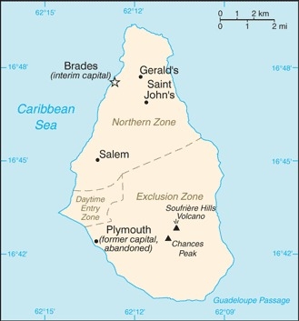
Montserrat is a British overseas territory located in the Leeward Islands, part of the chain of islands called the Lesser Antilles in the Caribbean Sea. It measures approximately 16 km (9.9 mi) long and 11 km (6.8 mi) wide, giving 40 kilometres (25 mi) of coastline.[1] Its capital city of Plymouth was destroyed by an eruption of the previously dormant Soufriere Hills volcano in 1995.[2] The eruption continues today on a much reduced scale, the damage being confined to the areas around Plymouth including its docking facilities and the former W.H. Bramble Airport.
Airports
| Location | ICAO | IATA | Airport name | Coordinates |
|---|---|---|---|---|
| Current airport | ||||
| Gerald's | TRPG | MNI | John A. Osborne Airport (Gerald's Airport) | 16°47′29″N 062°11′36″W |
| Former airport | ||||
| East coast of Montserrat | W. H. Bramble Airport (Blackburne Airport) | 16°45′32″N 62°9′23″W | ||
See also
- Transport in Montserrat
- List of airports by ICAO code: T#TR - Montserrat
- List of airports in the United Kingdom and the British Crown Dependencies
- Wikipedia: WikiProject Aviation/Airline destination lists: North America#Montserrat (United Kingdom)
References
- "ICAO Location Indicators by State" (PDF). International Civil Aviation Organization. 12 January 2006.
- "UN Location Codes: Montserrat". UN/LOCODE 2009-2. UNECE. 8 February 2010. - includes IATA codes
- Great Circle Mapper: Airports in Montserrat - IATA and ICAO airport codes
Footnotes
- Montserrat CIA World Factbook, 19 September 2006. Retrieved 1 October 2006.
- Montserrat Volcano Observatory Archived 2 October 2006 at the Wayback Machine Retrieved 2 October 2006.
Montserrat articles | ||||
|---|---|---|---|---|
| ||||
| Geography |  | |||
| Politics |
| |||
| Economy |
| |||
| Education |
| |||
| Culture |
| |||
| ||||
List of airports in the Americas | ||
|---|---|---|
| ||
| Sovereign states |
|  |
Dependencies and other territories |
| |
Текст в блоке "Читать" взят с сайта "Википедия" и доступен по лицензии Creative Commons Attribution-ShareAlike; в отдельных случаях могут действовать дополнительные условия.
Другой контент может иметь иную лицензию. Перед использованием материалов сайта WikiSort.org внимательно изучите правила лицензирования конкретных элементов наполнения сайта.
Другой контент может иметь иную лицензию. Перед использованием материалов сайта WikiSort.org внимательно изучите правила лицензирования конкретных элементов наполнения сайта.
2019-2025
WikiSort.org - проект по пересортировке и дополнению контента Википедии
WikiSort.org - проект по пересортировке и дополнению контента Википедии