avia.wikisort.org - Aerodrome
This is a list of airports in Yemen, sorted by location.
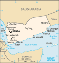
Yemen, officially the Republic of Yemen, is a country located in Western Asia, occupying the southwestern to southern end of the Arabian Peninsula. It is bordered by Saudi Arabia to the north, the Red Sea to the west, the Gulf of Aden and Arabian Sea to the south, and Oman to the east. The capital and largest city of Yemen is Sana'a.
Yemen is divided into twenty governorates (muhafazah) and the Capital district. The governorates are subdivided into 333 districts (muderiah), which are subdivided into 2,210 sub-districts, and then into 38,284 villages (as of 2001).
On 28 March 2015, a no-fly zone was imposed over the country by the Saudi Air Force as part of the 2015 military intervention in Yemen.[1] The blockade was lifted in November 2015 and reinstated in February 2016.[2] The blockade was lifted in November 2017.[3][4] Flights were cancelled once again, for four days (28-31 January 2018), but resumed on 1 February 2018.[5][6]
Airports
Airport names shown in bold currently have scheduled passenger service on commercial airlines (post-blockade, only flights approved by the Saudi-led alliance are permitted). Airport names shown in italic had no scheduled passenger flights before the blockade and currently still don't. The rest of the airports had commercial passenger flights before the blockade and all flights are currently suspended.[clarification needed]
| Location | Governorate | ICAO | IATA | Airport name | Coordinates |
|---|---|---|---|---|---|
| Abbs (Abbse) | Hajja Governorate | OYAB | EAB | Abbs Airport (Abbse Airport) | 16°00′40″N 43°10′40″E |
| Aden ('Adan) | 'Adan | OYAA | ADE | Aden International Airport | 12°49′46″N 045°01′44″E |
| Al Badie | Al Badie | OYBA | Al Badie Airport | 18°43′09.52″N 50°50′12.88″E | |
| Al Bayda' | Al Bayda' | OYBI | BYD | Al Bayda' Airport | 14°06′20″N 045°26′25″E |
| Al Ghaydah | Al Mahrah | OYGD | AAY | Al Ghaydah Airport | 16°11′30″N 052°10′30″E |
| Albuq (Al Buq, Al Bough) | Saada | OYBQ | BUK | Albuq Airport (Al Bough Airport) | 17°21′00″N 44°37′30″E |
| Ataq | Shabwah | OYAT | AXK | Ataq Airport | 14°33′04″N 046°49′34″E |
| Beihan | Shabwah | OYBN | BHN | Beihan Airport | 14°46′55″N 045°43′12″E |
| Canoxy | Canoxy | Canoxy Airport | 15°36′6.66″N 49°4′50.36″E | ||
| Hodeida (Al Hudaydah) | Al Hudaydah | OYHD | HOD | Hodeida International Airport | 14°45′11″N 042°58′35″E |
| Kamaran (Kamaran Island) | Al Hudaydah | OYKM | KAM | Kamaran Airport | 15°21′40″N 42°36′40″E |
| Marib (Ma'rib) | Ma'rib | OYMB | MYN | Marib Airport (construction suspended) | 15°28′10″N 45°19′40″E |
| Mukalla | Hadhramaut | OYRN | RIY | Riyan International Airport (Riyan Mukalla Airport) | 14°39′45″N 049°22′30″E |
| Mukeiras (Mukayras) | Abyan | OYMK | UKR | Mukeiras Airport | 13°56′10″N 45°39′20″E |
| Raudha | Raudha | RXA | Raudha Airport | 14°27′0″N 47°17′0″E | |
| Qishn | Al Mahrah | OYQN | IHN | Qishn Airport | |
| Saadah (Sa'dah) | Saada | OYSH | SYE | Saadah Airport | 16°58′00″N 43°43′45″E |
| Sanaa | Sana'a | OYSN | SAH | Sanaa International Airport (El Rahaba Airport) | 15°28′35″N 044°13′11″E |
| Seiyun | Hadhramaut | OYSY | GXF | Seiyun International Airport (Seiyun Hadhramaut Airport) | 15°57′58″N 048°47′17″E |
| Socotra | Socotra | OYSQ | SCT | Socotra Airport | 12°37′50″N 053°54′20″E |
| Taiz (Ta'izz) | Ta'izz | OYTZ | TAI | Taiz International Airport | 13°41′09″N 044°08′21″E |
See also
- Transport in Yemen
- List of airports by ICAO code: O#OY - Yemen
- Wikipedia: WikiProject Aviation/Airline destination lists: Asia#Yemen
References
- Ahmed, Adel (28 March 2015). "International Hani Mohammed / AP Stranded Yemeni-Americans consider alternate escape routes". Al-Jazeera. Retrieved 8 April 2015.
- "برنامج باريس". www.yemenia.com.
- "Aden airport receives first commercial flight after Yemen blockade". November 14, 2017 – via www.reuters.com.
- "Saudi-led coalition allows Yemen's Aden airport to resume daily flights - Xinhua | English.news.cn". www.xinhuanet.com. Archived from the original on March 7, 2018.
- "Yemen Airways resumes Aden flights". wam.
- "Yemen Airways to resume flights to and from Aden airport today". iinanews.org.
- "ICAO Location Indicators by State" (PDF). International Civil Aviation Organization. 17 September 2010.
- "UN Location Codes: Yemen". UN/LOCODE 2011-2. UNECE. 28 February 2012. - includes IATA codes
- "Airports in Yemen". Great Circle Mapper. Retrieved 7 October 2012.
- "Airports in Yemen". World Aero Data. Retrieved 7 October 2012.
List of airports in Asia | |
|---|---|
| Sovereign states |
|
| States with limited recognition |
|
| Dependencies and other territories |
|
| |
На других языках
[de] Liste der Flughäfen und Flugplätze im Jemen
Die Liste der Flughäfen und Flugplätze im Jemen umfasst die wichtigsten Flughäfen und Flugplätze des Jemens, sortiert nach Orten.- [en] List of airports in Yemen
[fr] Liste des aéroports au Yémen
Cette liste recense les aéroports au Yémen, classés par lieu.[ru] Список аэропортов Йемена
Это список аэропортов в Йемене, отсортированных по местоположению.Другой контент может иметь иную лицензию. Перед использованием материалов сайта WikiSort.org внимательно изучите правила лицензирования конкретных элементов наполнения сайта.
WikiSort.org - проект по пересортировке и дополнению контента Википедии