avia.wikisort.org - Aerodrome
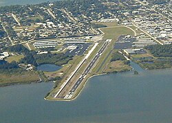
Merritt Island Airport (IATA: COI, ICAO: KCOI, FAA LID: COI) is a general aviation public airport under the administration of the Titusville-Cocoa Airport Authority. It located in Merritt Island, Brevard County, Florida, United States, northwest of Patrick Space Force Base.
Merritt Island Airport | |||||||||||
|---|---|---|---|---|---|---|---|---|---|---|---|
 | |||||||||||
| Summary | |||||||||||
| Airport type | Public | ||||||||||
| Owner | Titusville-Cocoa Airport Authority | ||||||||||
| Location | 900 Airport Road Merritt Island, Florida | ||||||||||
| Elevation AMSL | 5.9 ft / 1.8 m | ||||||||||
| Coordinates | 28°20′30″N 080°41′08″W | ||||||||||
| Runways | |||||||||||
| |||||||||||
History
In the early 1940s, the Brevard County Mosquito Control District constructed the Central Brevard Airport. The airfield included two sod landing strips: a north-south strip measuring approximately 1,800 feet in length, and a northwest southeast strip measuring approximately 3,000 feet in length.
An operations building and maintenance hangar were located on the south side of the airfield and the Mosquito Control District had a maintenance hangar on the north side of the airfield. The north-south landing strip was eventually abandoned, replaced by various facilities such as T-hangars that currently occupy this area. The Brevard County Mosquito Control District subsequently deeded the Central Brevard Airport property over to the Titusville-Cocoa Airport Authority in exchange for ten acres of land located within Space Coast Regional Airport. Central Brevard Airport was renamed Merritt Island Airport and became a public general aviation facility.[1]
Facilities

Merritt Island Airport covers 129 acres (52 ha) and has one runway:
- Runway 11/29: 3,601 ft × 75 ft (1,098 m × 23 m), surface: asphalt
Government activities
- Brevard County Sheriff's Office Aviation Unit
Businesses
- Space Coast Aviation[2] - Merritt Island's FBO
- 2FLY Airborne[3] - international pilot training
- Aerocomp - airplane manufacturer
- Buzz Airlines[4] - aircraft charters; has a base at the airport
- Voyager Aviation International[5] - flight training
- Sebastian Communication Inc.[6] - avionics sales, installation and repairs
References
- Titusville-Cocoa Airport Authority (official site)
- FAA Airport Form 5010 for COI PDF
- "Titusville-Cocoa Airport Authority". Archived from the original on 2006-06-19. Retrieved 2006-06-30.
- Space Coast Aviation
- 2FLY Airborne
- Buzz Airlines
- Voyager Aviation International
- Sebastian Communication Inc.
External links
- Resources for this airport:
- FAA airport information for COI
- AirNav airport information for KCOI
- ASN accident history for COI
- FlightAware airport information and live flight tracker
- NOAA/NWS weather observations: current, past three days
- SkyVector aeronautical chart, Terminal Procedures
Другой контент может иметь иную лицензию. Перед использованием материалов сайта WikiSort.org внимательно изучите правила лицензирования конкретных элементов наполнения сайта.
WikiSort.org - проект по пересортировке и дополнению контента Википедии