avia.wikisort.org - Aerodrome
Mischief Reef, also known as Panganiban Reef[1] (Tagalog: Bahura ng Panganiban); Vietnamese: Đá Vành Khăn; also known in Mandarin Chinese: 美濟礁/美济礁; pinyin: Měijì Jiāo; lit. 'Meiji Reef';, is a low tide elevation (LTE) reef/atoll surrounding a large lagoon in the SE of Dangerous Ground in the east of the Spratly Islands in the South China Sea. It is located 250 kilometres (130 nmi) west of Palawan Island of the Philippines. Administratively, it belonged to the Kalayaan Islands municipality of the province of Palawan.[2] Activities by the People's Republic of China (PRC) in the mid-2010s have created a large artificial island on the atoll which has included an approximately 2,700 metres (8,900 ft) runway and associated airfield.
This article may be expanded with text translated from the corresponding article in Chinese. (February 2019) Click [show] for important translation instructions.
|
| Disputed island Other names: 美濟礁 / 美济礁 Měijì Jiāo (Chinese) Panganiban Reef (Philippine English) Bahura ng Panganiban (Filipino) Đá Vành Khăn (Vietnamese) | |
|---|---|
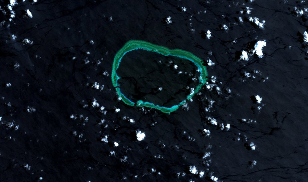
 Mischief Reef in 2018, after the major PRC land reclamations of 2014–2016 | |
 Mischief Reef | |
| Geography | |
| Location | South China Sea |
| Coordinates | 9°55′N 115°32′E |
| Archipelago | Spratly Islands |
| Administered by | |
| Province | Hainan |
| prefecture-level city | Sansha |
| Claimed by | |
Although the reef is well within the Philippines' EEZ and traditional fishing grounds, Mischief Reef has been controlled by the PRC since 1995, and is also claimed by the Republic of China (Taiwan), and Vietnam. The PRC performed various reclamation activities at least two locations on the rim of the atoll in the period from 1995 to 2013, but in the period from the end of 2013 to the end of 2016 a large artificial island of 1,379 acres (558 ha) was created around the majority of the perimeter of the lagoon.[3]
The reef was the subject of a 2016 tribunal ruling by the Permanent Court of Arbitration in The Hague, where the landmark ruling the Nine Dash Line as moot and without basis. Mischief reef was also ruled as a low tide elevation (LTE) meaning it cannot possess a territorial 12 mile-boundary regardless of the reclamation and a military base installation by the PRC. Their moves only heightened the tension with the Philippines, resulting to a massive defense acquisition of this archipelagic nation.
The area is said[4] to be rich in as of yet unexplored oil and gas fields.[5]
History and etymology
One source says that Mischief reef was discovered by Henry Spratly in 1791 and was named after the clipper Mischief that sailed regularly in the South China Sea in the 1850s.[6]
Location and description
Mischief reef is located at 9°55′N 115°32′E.[7] It lies 50 nautical miles east of Union Banks.[8] Mischief reef consists of a large lagoon and rocks that lie above water at low tide.[9]
Territorial disputes
In 1994 and 1995,[10] China built initial structures on stilts in the area. The Philippine government protested these actions. However, the Chinese government rejected the protest and said that the structures were shelter for fishermen. In 1999, another wave of protests from Manila occurred when China added more structures to Mischief Reef.[11]
China was also reported to have planted buoys in nearby Sabina Shoal. The Philippines claimed that China had a well-rehearsed routine when laying claim to a new reef: first put down buoys, then build concrete markers. Temporary wooden or bamboo shelters followed, and then permanent structures went up. The Philippines therefore would try to destroy the buoys or markers before China has time to build larger structures.[11] The Philippines' decision not to destroy the Chinese structures on Mischief Reef has prevented an escalation of the dispute. The Philippines claims that China has always been prepared for armed conflict when challenged, as is evident in China's defense of reefs from Vietnam in the 1988 Johnson South Reef Skirmish which resulted in more than 70 Vietnamese deaths.[11]
On 11 July 2012, the Chinese Type 053 frigate Dongguan ran aground on the reef, sparking embarrassment for the Chinese government and causing an awkward diplomatic situation. The ship was later towed back to base.[12]
On 12 July 2016, the tribunal of the Permanent Court of Arbitration concluded that Mischief Reef is, or in their natural condition was, exposed at low tide and submerged at high tide and are, accordingly low-tide elevations that do not generate entitlement to a territorial sea, exclusive economic zone or continental shelf.[13] The tribunal concluded that Mischief Reef forms part of the exclusive economic zone and continental shelf of the Philippines.[14]
Military development
In 2014, land reclamation started inside the rims.[15] The Philippines filed a diplomatic protest against China after the discovery of their reclamation activities.[16] By January 2016, work was well advanced on developing a military base with a large harbour and a 2,644 metres (8,675 ft) runway, with the reclaimed land covering 558 hectares (1,380 acres).[17] A civilian test flight to the runway was conducted by a China Southern Airlines passenger jet on 13 July 2016.[18]
In late 2016, photographs emerged which suggested that Mischief Reef was armed with anti-aircraft weapons and a CIWS missile-defence system.[19]
In early 2021, satellite imagery and third party geointelligence analysis confirmed a radome and possible antenna mount, among other construction preparations underway on Mischief Reef.[20]
Meiji Airport
Meiji Airport | |||||||||||
|---|---|---|---|---|---|---|---|---|---|---|---|
| |||||||||||
| Summary | |||||||||||
| Airport type | Military | ||||||||||
| Owner | |||||||||||
| Operator | People's Liberation Army Navy | ||||||||||
| Location | Mischief Reef | ||||||||||
| Map | |||||||||||
 Meiji Airport Location of airport in the South China Sea | |||||||||||
| Runways | |||||||||||
| |||||||||||
See also
- Great wall of sand
- Nine-dash line
References
- "The battle for Mischief Reef". Warfighter.org. Archived from the original on 20 August 2016. Retrieved 27 November 2013.
- "Map of Mischief reef". Wikimapia. Retrieved 17 March 2014.
- Mischief Reef Tracker, amti.csis.org
- Raman, B (1999). Chinese Territorial Assertions: The Case of the Mischief Reef. Chennai, India: Institute For Topical Studies. Archived from the original on 20 August 2016. Retrieved 27 November 2013.
- Meyer, Lt Col. Stanley E (1996). Incident at Mischief reef : Implications for The Philippines, China and The United States (PDF). Pennsylvania, USA: US Army war college, Carlisle barracks. Archived from the original on 3 December 2013.
- Forbes, Robert (1885). Notes on the ships of the past (1st ed.). Boston: J.F.Cotter and Co. p. 48.
- Hancox, David; Prescott, Victor (1995). A Geographical Description of the Spratly Islands and an Account of Hydrographic Surveys amongst Those Islands. Maritime Briefings. Vol. 1. University of Durham, International Boundaries Research Unit. p. 29. ISBN 978-1897643181.
- Campbell, Eric (20 May 2014). "Reef madness". Foreign Correspondent. ABC News. Retrieved 22 May 2014.
- Cire Sarr (19 August 2001). "Digital Gazetteer of Spratly Islands". www.southchinasea.org. Retrieved 7 October 2014.
- Ian Storey; Herbert Yee (2004). The China threat : Perceptions and myths. Routledge. ISBN 0415347106.
- McCarthy, Terry (8 March 1999). "Reef Wars". Time Asia. Puerto Princessa, Palawan. 153 (9). Archived from the original on 14 February 2001. Retrieved 22 March 2008.
- Tania Branigan. "Chinese frigate runs aground in disputed part of South China Sea". The Guardian.
- "Award" (PDF). Permanent Court of Arbitration. 12 July 2016. Archived from the original (PDF) on 29 January 2019. Retrieved 17 July 2016. p.174
- "Award" (PDF). Permanent Court of Arbitration. 12 July 2016. Archived from the original (PDF) on 29 January 2019. Retrieved 17 July 2016. p.260
- David E. Sanger and Rick Gladstone, "Piling Sand in a Disputed Sea, China Literally Gains Ground", The New York Times, 8 April 2015.
- Del Callar, Michaela (10 February 2015). "PHL files new diplomatic protest over China's reclamation in Mischief Reef". GMA News. Retrieved 24 May 2016.
- "Airstrips near Completion". Asia Maritime Transparency Initiative. January 2016. Retrieved 30 January 2016.
- "China conducts test flights on two new airports on Nansha Islands". Xinhua. Archived from the original on 14 July 2016. Retrieved 14 July 2016.
- "China's New Spratly Island Defenses". Center for Strategic and International Studies. 13 December 2016. Retrieved 17 December 2016.
- "Feb 2021: New Construction on Mischief Reef". Simularity. Retrieved 17 February 2021.
Further reading
- Meyer, Stanley E. (1996). "Incident at Mischief Reef: Implications for the Philippines, China, and the United States". U.S. Army War College.
External links
| Confrontations |
| ||||||||||||
|---|---|---|---|---|---|---|---|---|---|---|---|---|---|
| Regions |
| ||||||||||||
| Occupied features |
| ||||||||||||
| Unoccupied features |
| ||||||||||||
| Related articles |
| ||||||||||||
| Pratas Island |
| ||||||||||||||||
|---|---|---|---|---|---|---|---|---|---|---|---|---|---|---|---|---|---|
| Paracel Islands |
| ||||||||||||||||
| NorthEast SCS |
| ||||||||||||||||
| Spratly Islands |
| ||||||||||||||||
| Southern SCS |
| ||||||||||||||||
| Tudjuh Archipelago | |||||||||||||||||
| History |
| ||||||||||||||||
| Transport |
| ||||||||||||||||
| |||||||||||||||||
На других языках
[de] Meiji Jiao
Meiji Jiao (美济礁), auch Mischief-Riff, ist ein Atoll der Spratly-Inseln im Südchinesischen Meer. Seit 2015 treibt die Volksrepublik China den Bau eines Luftwaffenstützpunktes im Norden des Atolls voran.- [en] Mischief Reef
[fr] Récif Mischief
Le récif Mischief, aussi connu sous le nom du récif Meiji (chinois : 美济礁 ; pinyin : měijìjiāo), en tagalog Panganiban reef, est un récif dans l'archipel des îles Spratleys dans le sud de la mer de Chine à 250 kilomètres des côtes des Philippines[1].Другой контент может иметь иную лицензию. Перед использованием материалов сайта WikiSort.org внимательно изучите правила лицензирования конкретных элементов наполнения сайта.
WikiSort.org - проект по пересортировке и дополнению контента Википедии