avia.wikisort.org - Flugplatz
Der Flughafen Villahermosa (spanisch Aeropuerto Internacional de Villahermosa) ist ein internationaler Flughafen bei der Großstadt Villahermosa im Bundesstaat Tabasco in Mexiko.
| Flughafen Villahermosa | ||
|---|---|---|
 | ||
|
 Kenndaten | ||
| ICAO-Code | MMVA | |
| IATA-Code | VSA | |
| Koordinaten | ||
| Höhe über MSL | 14 m (46 ft) | |
| Verkehrsanbindung | ||
| Entfernung vom Stadtzentrum | 16 km östlich von Villahermosa | |
| Basisdaten | ||
| Betreiber | Grupo Aeroportuario del Sureste | |
| Start- und Landebahn | ||
| 08/26 | 2200 m × 45 m Asphalt | |
Lage
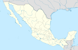
Der Flughafen Villahermosa befindet sich etwa 50 km (Luftlinie) südlich der Küste des Golfs von Mexiko und etwa 600 km südöstlich von Mexiko-Stadt in einer Höhe von ca. 14 m.
Flugverbindungen
Es werden hauptsächlich nationale Flüge nach Mexiko-Stadt und anderen mexikanischen Städten abgewickelt.[1][2][3]
Passagierzahlen
In den Jahren 2015 bis 2019 wurden jeweils annähernd 1,25 Millionen Passagiere abgefertigt. Danach erfolgte ein deutlicher Rückgang infolge der COVID-19-Pandemie.
Weblinks
Commons: Flughafen Villahermosa – Sammlung von Bildern, Videos und Audiodateien
- Flughafen Villahermosa – Kurzinfos (englisch)
Einzelnachweise
На других языках
- [de] Flughafen Villahermosa
[en] Villahermosa International Airport
Carlos Rovirosa Pérez International Airport or Villahermosa International Airport (IATA: VSA, ICAO: MMVA) is an international airport serving Villahermosa, the capital of the Mexican state of Tabasco. It is also commonly used to access the Maya ruins of Palenque, a popular tourist destination.[es] Aeropuerto Internacional Carlos Rovirosa Pérez
El Aeropuerto Internacional Carlos Rovirosa Pérez o Aeropuerto Internacional de Villahermosa (Código IATA: VSA - Código OACI: MMVA - Código DGAC: VSA[1]), es un aeropuerto localizado en Villahermosa, Tabasco, y maneja el tráfico aéreo nacional e internacional de la Zona Metropolitana de Villahermosa, del estado de Tabasco y norte de Chiapas.[fr] Aéroport international de Villahermosa
L'aéroport international Carlos Rovirosa Pérez ou l'aéroport international de Villahermosa (code IATA : VSA • code OACI : MMVA • code DGAC M. : VSA) est un aéroport international desservant Villahermosa, capitale de l'État mexicain de Tabasco. C'est également l'aéroport principal le plus proche des ruines mayas de Palenque, une destination touristique prisée.Текст в блоке "Читать" взят с сайта "Википедия" и доступен по лицензии Creative Commons Attribution-ShareAlike; в отдельных случаях могут действовать дополнительные условия.
Другой контент может иметь иную лицензию. Перед использованием материалов сайта WikiSort.org внимательно изучите правила лицензирования конкретных элементов наполнения сайта.
Другой контент может иметь иную лицензию. Перед использованием материалов сайта WikiSort.org внимательно изучите правила лицензирования конкретных элементов наполнения сайта.
2019-2025
WikiSort.org - проект по пересортировке и дополнению контента Википедии
WikiSort.org - проект по пересортировке и дополнению контента Википедии
