avia.wikisort.org - Aerodrome
El Alto International Airport (Spanish: Aeropuerto Internacional El Alto) (IATA: LPB, ICAO: SLLP) is an international airport serving La Paz, Bolivia. It is located in the city of El Alto,[2] 13 kilometres (8 mi) west of La Paz.[3] At an elevation of 4,061.5 metres (13,325 ft), it is the highest international airport, the sixth highest commercial airport in the world and the highest commercial airport outside of China.[4]
El Alto International Airport Aeropuerto Internacional El Alto | |||||||||||||||
|---|---|---|---|---|---|---|---|---|---|---|---|---|---|---|---|
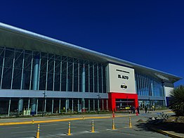 Main terminal | |||||||||||||||
| |||||||||||||||
| Summary | |||||||||||||||
| Airport type | Public / Military | ||||||||||||||
| Owner | Government of Bolivia | ||||||||||||||
| Operator | SABSA Nacionalizada | ||||||||||||||
| Serves | La Paz, Bolivia | ||||||||||||||
| Location | El Alto, Bolivia | ||||||||||||||
| Hub for | |||||||||||||||
| Focus city for | |||||||||||||||
| Elevation AMSL | 4,061.5 m / 13,325 ft | ||||||||||||||
| Coordinates | 16°30′48″S 068°11′32″W | ||||||||||||||
| Website | www | ||||||||||||||
| Map | |||||||||||||||
 LPB Location of airport in Bolivia | |||||||||||||||
| Runways | |||||||||||||||
| |||||||||||||||
| Statistics (2013) | |||||||||||||||
| |||||||||||||||
Source: SABSA,[1] Airport Statistics | |||||||||||||||
The airport has been in service since the first half of the 20th century, but was modernized in the late 1960s, when its runway was lengthened and a new passenger terminal with modern facilities was built. The new airport was inaugurated in 1965.[5] El Alto airport was a primary hub for the former Lloyd Aéreo Boliviano, Bolivia's flag carrier which ceased operations in 2007 and is a hub for Línea Aérea Amaszonas. It serves also as a focus city for Boliviana de Aviación which is a state-owned airline.[6]
History


Bolivia is characterized by an extremely varied terrain including rugged mountains, high plateaus, low valleys and tropical forests; this topography has had a negative effect on national transportation, making communication difficult between elevated and low cities along with isolated tropical towns. Aviation is an important solution for isolated communities in this environment.
Bolivian air transport started in 1916, when the Military school of Aviation (Spanish: Escuela Militar de Aviación) was formed in La Paz. In 1929 the local La Paz Government first planned the construction of an airport. However it was not officially inaugurated until the 1960s. In 1974 the airport was reconstructed, a new terminal was built and its facilities were enlarged and modernized.[7] Until 1999 the airport had John F. Kennedy (JFK) as its official name although in practice this name was never publicly used. In that year, before the pressure of different sectors, by means of the Law 1944 during the government of Hugo Banzer Suárez the airport changed its name officially to El Alto International Airport.
Modernization
In 2006, SABSA (Spanish: Servicios Aeroportuarios Bolivianos S.A.) invested nearly 2.3 million dollars in the reconstruction of the main terminal.[8] The new terminal consists of the enlargement, reshaping and construction of the baggage claim room, the check-in area and the corridor to the air bridges. The administrative offices of AASANA as well as the main hall and the international area were completely modernized.[9]
Characteristics

The new terminal includes various shops offering Bolivian handicrafts as well as bookstores, and duty-free shops. There are also restaurants and cafes in the main lobby and in both domestic and international departure areas.
The airport has two runways: The main one "10R/28L" has a concrete surface and is 4,000 metres (13,123 ft) long, allowing large aircraft operations at higher altitudes. A second runway, "10L/28R" is located parallel to the main runway and has a grass surface. The airport is equipped with VOR/DME, DVOR/DME navigation systems, as well as ILS CAT I approach systems.
El Alto is the world's highest international airport, located at 4,062 metres (13,327 ft) above sea level. The average temperature at the airport is 6 °C (43 °F). Because of the thin high altitude air, most commercial wide-body aircraft such as the Boeing 747 and Airbus A330 cannot operate at full load out of El Alto International Airport. As a result, much of the international traffic to and from Bolivia operates out of Viru Viru International Airport in Santa Cruz de la Sierra which is located at a much lower elevation, allowing heavy aircraft operations.
Flight testing
As one of the world's highest-elevation airports, El Alto offers features taken advantage of by aircraft manufacturers such as Airbus and Boeing to test high-altitude takeoff and landing. Modern aircraft such as the Airbus A350 XWB and Boeing 787 have used El Alto to perform flight tests for their certification processes.[10][11]
Operators
From 1997, the airport was managed by TBI plc which owned concessions of the three biggest airports in the country: El Alto International Airport, Jorge Wilstermann International Airport and Viru Viru International Airport through its subsidiary Servicio de Aeropuertos Bolivianos S.A. (SABSA). In 1999 Airport Group International was purchased by TBI plc. In 2004, the company was acquired by the Spanish conglomerate Abertis, hence taking ownership of SABSA. In February 2013, the Government of Bolivia announced the nationalization of SABSA, taking full ownership and operations of Bolivia's main international gateways.[12][13]
Airlines and destinations


| Airlines | Destinations |
|---|---|
| Amaszonas | Santa Cruz de la Sierra–Viru Viru |
| Avianca | Bogotá |
| Boliviana de Aviación | Cobija, Cochabamba, Santa Cruz de la Sierra–Viru Viru, Sucre, Tarija, Trinidad, Uyuni |
| EcoJet | Cobija, Cochabamba, Trinidad |
| LATAM Chile | Santiago de Chile |
| LATAM Perú | Lima |
Accidents and incidents
- On 14 July 1970, Douglas DC-3 TAM-17 of TAM – Transporte Aéreo Militar was damaged beyond repair in an accident.[14]
- On 4 May 1971, Douglas C-47 TAM-22 of TAM – Transporte Aéreo Militar crashed shortly after take-off on a cargo flight to El Jovi Airport.[15]
- On 17 September 1972, Douglas C-47A CP-565 of Aerolíneas Abaroa crashed on take-off. The aircraft was operating a non-scheduled passenger flight. All four people on board survived.[16]
- On 18 August 1974, a C-141 Starlifter impacted a mountain during approach. All seven crew members were killed.[17]
- On 25 November 1976, Douglas C-47 CP-755 of Aerolíneas La Paz was damaged beyond economic repair in a landing accident. The aircraft was on a cargo flight, all four people on board survived.[18]
- On 1 January 1985, Eastern Air Lines Flight 980 from Asuncion hit Mount Illimani during its descent towards El Alto, killing all 29 people on board the Boeing 727-225; the flight was scheduled to continue to Lima, Guayaquil, Panama City, Miami, and Chicago.
See also
- List of airports in Bolivia
- List of highest commercial airports
References
- "Sabsa - Aeropuerto El Alto". Archived from the original on 31 May 2011. Retrieved 31 October 2017.
- "El Alto - La Paz". Retrieved 31 October 2017.[permanent dead link]
- "La Paz Airport (LPB) guide to buses, taxis and trains at El Alto International Airport". www.wordtravels.com. Archived from the original on 27 September 2011. Retrieved 1 July 2011.
- "The Highest International Airport in the World - Grand Escapades". 26 October 2007. Archived from the original on 13 December 2013. Retrieved 8 December 2013.
- "El Alto Airport and La Paz" (in Spanish). Archived from the original on 26 March 2012. Retrieved 31 October 2017.
- "AeroSur Hub". Archived from the original on 17 March 2012.
- http://www.gobernacionlapaz.gob.bo:8001/simit/sistema/ficha_turistica/fichaturistica.php?atr_id=254%5B%5D
- (in Spanish) http://www.mirabolivia.com/foro_total.php?id_foro_ini=51639 Archived 14 July 2011 at the Wayback Machine Con una inversión de 2,3 millones de dólares
- (in Spanish) http://www.mirabolivia.com/foro_total.php?id_foro_ini=51639 Archived 14 July 2011 at the Wayback Machine
- "A350 XWB in Bolivia for high altitude testing". www.airbus.com. 9 January 2014. Archived from the original on 27 June 2015.
- "Boeing 787 Nears FAA Approval as Flight Tests Are Completed". www.bloomberg.com. 17 August 2011. Archived from the original on 19 October 2017.
- "Bolivia nationalizes Spanish-owned airports operator". www.reuters.com. Reuters. Archived from the original on 24 September 2015. Retrieved 24 June 2015.
- "Evo Morales, Bolivia President, Nationalizes Spanish-Owned Airport Company SABSA". The Huffington Post. Archived from the original on 26 June 2015. Retrieved 24 June 2015.
- "TAM-17 Accident description". Aviation Safety Network. Archived from the original on 3 November 2012. Retrieved 20 October 2010.
- "TAM-22 Accident description". Aviation Safety Network. Archived from the original on 11 October 2010. Retrieved 19 September 2010.
- "CP-565 Accident description". Aviation Safety Network. Archived from the original on 14 October 2010. Retrieved 7 September 2010.
- "C-141 Lifetime Mishap Summary". c141heaven.info. Retrieved 22 December 2019.
- "CP-755 Accident description". Aviation Safety Network. Archived from the original on 2 November 2012. Retrieved 15 August 2010.
External links
![]() Media related to El Alto International Airport at Wikimedia Commons
Media related to El Alto International Airport at Wikimedia Commons
- Aeropuerto Internacional El Alto at SABSA website
- Weather in La Paz – El Alto Airport
- Accident history for LPB at Aviation Safety Network
На других языках
[de] Flughafen El Alto
Der Aeropuerto Internacional El Alto ist der internationale Flughafen von La Paz in Bolivien. Er liegt auf dem Gebiet der Nachbarstadt El Alto, rund 13 Kilometer westsüdwestlich von La Paz.- [en] El Alto International Airport
[es] Aeropuerto Internacional El Alto
El Aeropuerto Internacional de El Alto (IATA: LPB, ICAO: SLLP) es el aeropuerto principal del área metropolitana de La Paz y uno de los más importantes y transitados de Bolivia. Está ubicado en las inmediaciones de El Alto, a 14,5 kilómetros al noroeste del centro de La Paz. Situado a una altura de 4061m s. n. m., el aeropuerto Internacional de El Alto es el aeropuerto internacional más alto del mundo.[1] La terminal es además uno de los asentamientos de la I Brigada Aérea de la Fuerza Aérea Boliviana, el Grupo Aéreo Presidencial y la Base aérea Bartolina Sisa.[fr] Aéroport international El Alto
L'aéroport international El Alto (code IATA : LPB • code OACI : SLLP) est un aéroport domestique et international desservant la ville de La Paz, capitale du département de La Paz, celui-ci étant situé à l'ouest de la Bolivie. Il est précisément situé dans la ville voisine d'El Alto.[it] Aeroporto Internazionale di El Alto
L'Aeroporto Internazionale di El Alto è un aeroporto situato in Bolivia nei pressi della città di El Alto, dipartimento di La Paz. È l'aeroporto più vicino alla città di La Paz, che si trova a circa 14 km. Trovandosi a oltre 4000 metri d'altezza, è l'aeroporto internazionale più alto del mondo.[ru] Эль-Альто (аэропорт)
Международный аэропорт Эль-Альто (исп. Aeropuerto Internacional El Alto) — аэропорт города Ла-Пас, столицы Боливии, расположенный в пригороде Эль-Альто.Другой контент может иметь иную лицензию. Перед использованием материалов сайта WikiSort.org внимательно изучите правила лицензирования конкретных элементов наполнения сайта.
WikiSort.org - проект по пересортировке и дополнению контента Википедии