avia.wikisort.org - Aerodrome
Nyoma[lower-alpha 1] is a principal village of southern Ladakh in India, the headquarters of an eponymous subdivision, tehsil and community development block in the Leh district.[4][5] It is located on the bank of the Indus river, after its 90-degree bend near Dungti and before the valley narrows to a gorge near Mahe. A Buddhist monastery ("gompa") is located on the hill at the back of the village.
Nyoma
Nyama, Neoma | |
|---|---|
Village | |
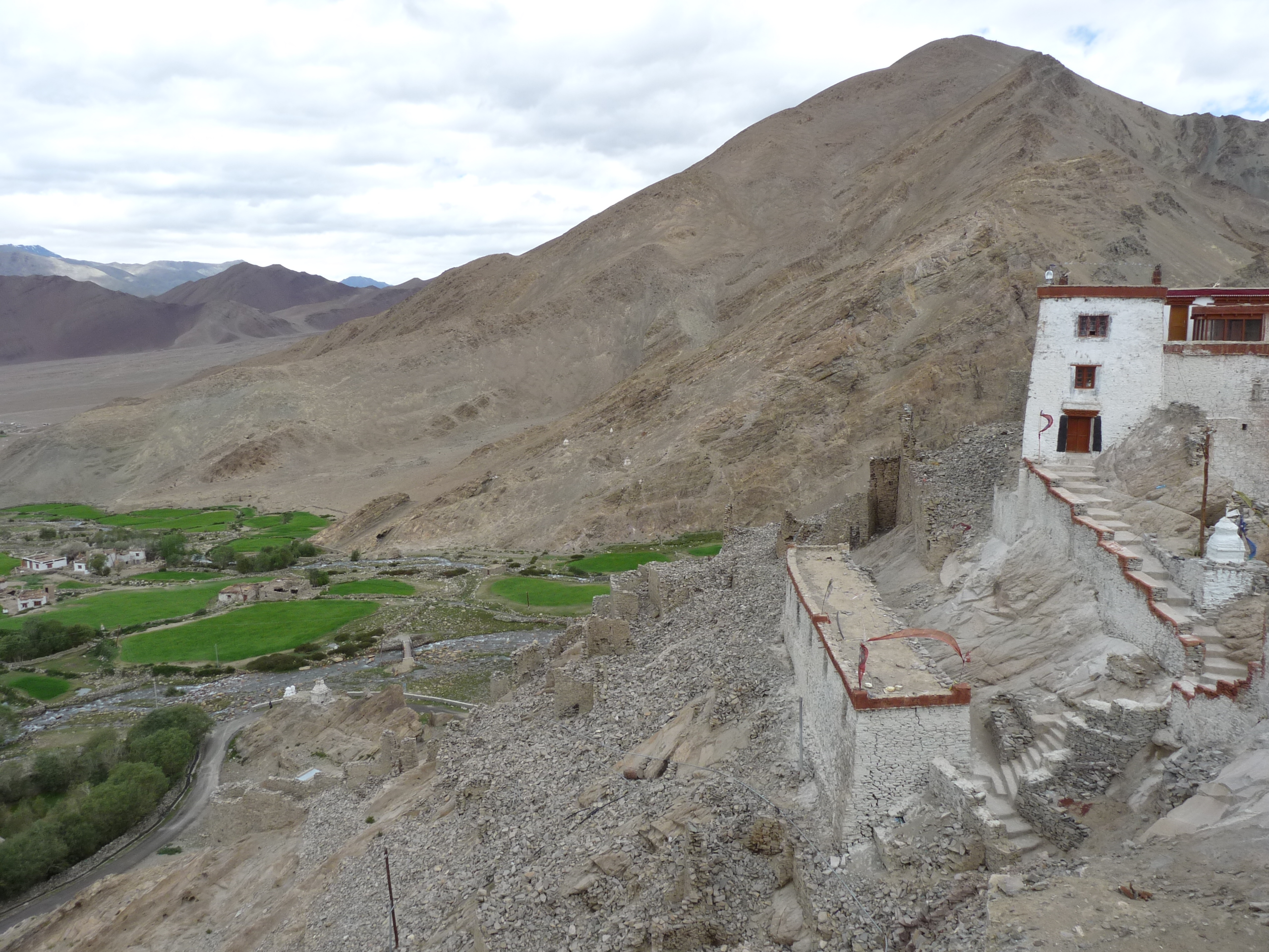 Nyoma's setting as seen from the gompa (Buddhist monastery) | |
 Nyoma Location in Ladakh  Nyoma Nyoma (India) | |
| Coordinates: 33.2059163°N 78.6483843°E | |
| Country | |
| Union territory | Ladakh |
| District | Leh |
| Tehsil | Nyoma |
| Elevation | 4,180 m (13,710 ft) |
| Population (2011) | |
| • Total | 918 |
| Languages | |
| • Official | Hindi, English |
| Time zone | UTC+5:30 (IST) |
| PIN | 194404 |
| 2011 census code | 901 |
The Nyoma tehsil and subdivision cover the entire southern Ladakh, including the Rupshu plains, the Hanle valley and the Indus valley of Skakjung.
Military facilities
Nyoma Airbase
Indian Military has an operational airbase at Nyoma. In 2022, the airbase received Wildlife Board's forests clearance for expansion in 508 hectares land inside Changthang Wildlife Sanctuary.[6]
Field Firing Range
Nearby Mahe has Indian Military's "Mahe Field Firing Range" (MFFR) on 1259.25 hectares land inside the Changthang Wildlife Sanctuary. Firing range is 40 to 50 km from the disputed India-China Line of Actual Control. This is the one of its type firing range in the entire Indian-held Ladakh region where all types of weapons can be fired.[7]
Fiber optical cable for internet & telephony
In 2022, wildlife clearance was also granted for laying optical fiber cables in the Changthang Wildlife Sanctuary and Karakoram Wildlife Sanctuary for the internet and telephony connectivity.[7]
Location and geography

The Indus river after its entry into Ladakh flows in a southwesterly direction through a wide valley. Afterwards, it takes a 90-degree bend at Dungti blocked by the higher ground of the Chushul valley. The village of Nyoma lies 33 km west of the bend on the right bank (northern bank), where it is also coupled with another neighbouring village Mood (or Mud or Mad). The Indus river here is said to be wide and shallow. It could be easily forded.[1][8]
Nyoma is located 41 km southeast of Chumathang,[9] and 87 km south of Chushul. Nearby villages are Mahe and Loma. Hanle, the largest village in southern Ladakh, is 80 km to the southeast. Mount Sajum on the border with China is 43 km to the east.[lower-alpha 2]
Border infrastructure
The Nyoma tehsil borders the Tibet Autonomous Region of China on the south and the east. The southern border runs along the Chumar village in Rupshu and the Imis Pass at the end of the Hanle valley. The eastern border, a Line of Actual Control resulting from the 1962 war with China, runs along the Kailash Range watershed of the Indus river till the village of Dumchele and narrows to the right bank of the Indus river up to Demchok. The border in the Demchok sector remains disputed.
Nyoma is home to an Advanced Landing Ground of Indian Airforce, which was first built in 1962. It was reactivated in 2009 when an An-32 landed in this airfield.[2]
The road from Leh runs till the village of Koyul, crossing the Indus river at Loma. From Koyul to Demchok, there is only a rough track. An alternative border road runs between the Koyul Lungpa valley and Demchok via the Umling La pass.[10][11] Roads infrastructure this area is being enhanced under the India-China Border Roads projects.
Tourism
Since 2010, foreign tourists with Inner Line Permits are permitted to visit Nyoma and its monastery.
Civil administration
Nyoma subdivision
The permanent civilian habitations under the administration of the Nyoma Community Development Block (district subdivision) include villages like Nayoma, Hanle, Koyul, Demchok, Tsaga, Mudh, Rongo, Nyedar, etc.[12]
Nyoma village
Demographics
According to the 2011 census of India, Nyoma has 202 households. The effective literacy rate (i.e. the literacy rate of population excluding children aged 6 and below) is 49.94%.[13]
| Total | Male | Female | |
|---|---|---|---|
| Population | 918 | 427 | 491 |
| Children aged below 6 years | 125 | 63 | 62 |
| Scheduled caste | 2 | 0 | 2 |
| Scheduled tribe | 707 | 329 | 378 |
| Literates | 396 | 198 | 198 |
| Workers (all) | 345 | 212 | 133 |
| Main workers (total) | 160 | 100 | 60 |
| Main workers: Cultivators | 40 | 28 | 12 |
| Main workers: Agricultural labourers | 6 | 1 | 5 |
| Main workers: Household industry workers | 5 | 4 | 1 |
| Main workers: Other | 109 | 67 | 42 |
| Marginal workers (total) | 185 | 112 | 73 |
| Marginal workers: Cultivators | 13 | 9 | 4 |
| Marginal workers: Agricultural labourers | 119 | 68 | 51 |
| Marginal workers: Household industry workers | 4 | 0 | 4 |
| Marginal workers: Others | 49 | 35 | 14 |
| Non-workers | 573 | 215 | 358 |
See also
- India-China Border Roads
- Line of Actual Control
- List of disputed territories of India
Notes
- Variations of the spelling include "Nyama",[1] and "Neoma".[2] The village was referred to as "Nimu" or "Nima" during the British Raj period.[3][1]
- The border at Mount Sajum is undisputed. However, there are persisting disputes regarding the Demchok sector to the south and the Chushul sector to the north.
References
- Gazetteer of Kashmir and Ladak (1890), p. 624.
- New IAF airfield to be reopened in east Ladakh, The Economic Times, 6 April 2009.
- Drew, The Jummoo and Kashmir Territories (1875), p. 313, footnote; p. 316.
- "Blockwise Village Amenity Directory" (PDF). Ladakh Autonomous Hill Development Council. Retrieved 23 July 2015.
- Leh subdivision-blocks.
- "Eye on India, China raises Tibet military command rank | Central Tibetan Administration". tibet.net. Retrieved 1 October 2016.
- "Central wildlife panel approves to upgrade IAF base near LAC in Ladakh". www.business-standard.com. Retrieved 12 September 2022.
- Schomberg, R. C. F. (1950), "Expeditionts: The Tso Morari to the Tibetan Frontier at Demchok", Himalayan Journal, XVI (1): 105
- Directions from Chumathang to Nyoma, distancesfrom.com, retrieved 15 November 2020.
- "BRO builds world's highest motorable road in Ladakh at 19,300 feet". Livemint. 2 November 2017. Archived from the original on 2 November 2017.
- "Achievements of West DTE during the F/Y 2016-17" (PDF). Border Roads Organisation. Archived (PDF) from the original on 7 November 2017.
- Successive govts have neglected border areas of Ladakh: Nyoma's BDC chair, Economic Times, 24 June 2020.
- "Leh district census". 2011 Census of India. Directorate of Census Operations. Retrieved 23 July 2015.
Bibliography
- Gazetteer of Kashmir and Ladak, Calcutta: Superintendent of Government Printing, 1890
- Drew, Frederic (1875), The Jummoo and Kashmir Territories: A Geographical Account, E. Stanford – via archive.org
External links
![]() Media related to Nyoma at Wikimedia Commons
Media related to Nyoma at Wikimedia Commons
Capital: Kargil; Leh | |||||||||||||||||||
| State symbols |
| ||||||||||||||||||
| History |
| ||||||||||||||||||
| Administration |
| ||||||||||||||||||
| Geography |
| ||||||||||||||||||
| Human settlements | |||||||||||||||||||
| Culture |
| ||||||||||||||||||
| Tourism and wildlife |
| ||||||||||||||||||
| Transport |
| ||||||||||||||||||
| Infrastructure |
| ||||||||||||||||||
| See also |
| ||||||||||||||||||
| Leadership |
| ||||||||||||||||||||||||||||||||||||||||||||
|---|---|---|---|---|---|---|---|---|---|---|---|---|---|---|---|---|---|---|---|---|---|---|---|---|---|---|---|---|---|---|---|---|---|---|---|---|---|---|---|---|---|---|---|---|---|
| Components & commands |
| ||||||||||||||||||||||||||||||||||||||||||||
| Military academies |
| ||||||||||||||||||||||||||||||||||||||||||||
| Insignia |
| ||||||||||||||||||||||||||||||||||||||||||||
| History & future |
| ||||||||||||||||||||||||||||||||||||||||||||
| Other |
| ||||||||||||||||||||||||||||||||||||||||||||
| |||||||||||||||||||||||||||||||||||||||||||||
На других языках
- [en] Nyoma
[ru] Ньома
Ньома Рап или Няма (произносится Неома) — город в округе Лех, Ладакх в северной Индии[1].Другой контент может иметь иную лицензию. Перед использованием материалов сайта WikiSort.org внимательно изучите правила лицензирования конкретных элементов наполнения сайта.
WikiSort.org - проект по пересортировке и дополнению контента Википедии