avia.wikisort.org - Aerodrome
Royal Air Force Kingsnorth or more simply RAF Kingsnorth is a former Royal Air Force Advanced Landing Ground in Kent, England. It was at Bliby Corner approximately 2 miles (3.2 km) southeast of Ashford; about 50 miles (80 km) southeast of London. It is not to be confused with RNAS Kingsnorth, later RAF Kingsnorth, which was an airship station in operation during and after the First World War.
| RAF Kingsnorth USAAF Station AAF-418  | |||||||||
|---|---|---|---|---|---|---|---|---|---|
| Kingsnorth, Kent in England | |||||||||
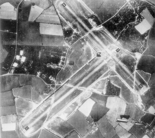 Kingsnorth airfield, 12 May 1944, photo oriented to the west (top), taken about three weeks before D-Day. The crossroads in the middle of the picture is Bliby Corner, with Sevington Lane running left-right and Chequertree Lane going top-bottom. | |||||||||
 RAF Kingsnorth Shown within Kent | |||||||||
| Coordinates | 51°6′18″N 0°53′20″E | ||||||||
| Type | Advanced landing ground | ||||||||
| Code | IN | ||||||||
| Site information | |||||||||
| Owner | Air Ministry | ||||||||
| Operator | Royal Air Force United States Army Air Forces 1944 | ||||||||
| Controlled by | RAF Fighter Command 1943-44 | ||||||||
| Site history | |||||||||
| Built | 1943 | ||||||||
| Built by | RAF Airfield Construction Service | ||||||||
| In use | July 1943 - January 1945 | ||||||||
| Battles/wars | European theatre of World War II | ||||||||
| Airfield information | |||||||||
| Elevation | 38 metres (125 ft)[1] AMSL | ||||||||
| |||||||||
Opened in 1943, Kingsnorth was one of a number of prototype temporary Advanced Landing Ground airfields to be built in France after D-Day, as the Allied forces moved east across France and Germany. Kingsnorth was used by British, Dominion and the United States Army Air Forces until it was closed in September 1944.
Today the airfield is agricultural land with few remains visible on the ground, although sections of the runways can clearly be made out on aerial and satellite photos.
History
The USAAF Ninth Air Force required several temporary Advanced Landing Ground (ALG) along the channel coast prior to the June 1944 invasion of Normandy to provide tactical air support for the ground forces landing in France.
RAF Fighter Command use
| Unit | Dates | Aircraft | Variant | Notes |
|---|---|---|---|---|
| No. 19 Squadron RAF | August–September 1943 | Supermarine Spitfire | IX | [2] |
| No. 65 Squadron RAF | July–October 1943 | Supermarine Spitfire | IX | [3] |
| No. 122 Squadron RAF | July–October 1943 | Supermarine Spitfire | IX | [4] |
| No. 184 Squadron RAF | August 1943 | Hawker Hurricane | IV | [5] |
| No. 602 Squadron RAF | July–August 1943 | Supermarine Spitfire | VB | [6] |
| No. 2809 Squadron RAF Regiment | N/A | N/A | Airfield Defence[7] | |
| No. 122 Airfield | N/A | N/A | [7] |
USAAF use

Kingsnorth was known as USAAF Station AAF-418 for security reasons by the USAAF during the war, and by which it was referred to instead of location. Its USAAF Station Code was "KN".
36th Fighter Group
The availability date of 1 April 1944 was achieved and between the 4th and 6th of that month approximately 1,500 men of the 36th Fighter Group arrived at Kingsnorth airfield from Scribner Army Airfield, Nebraska flying Republic P-47 Thunderbolts. Operational fighter squadrons and fuselage codes were:
- 22d Fighter Squadron (3T)
- 23d Fighter Squadron (7U)
- 53d Fighter Squadron (6V)
The 36th Fighter Group was part of the 303d Fighter Wing, XIX Tactical Air Command.
Movement to the Continent commenced during the first week of July when the 53rd Fighter Squadron transferred to its Advanced Landing Ground (ALG) at Brucheville, France (ALG A-16) as a forward base. The other two squadrons continued to operate from Kingsnorth until early August, the main body of the group preparing to move on the 2nd. Within a few days all personnel were gone and the airfield was deserted.
Current use
With the facility released from military control, the former airfield was returned rapidly to agricultural use and within a very short period there was little to indicate that RAF Kingsnorth had existed. Today the only evidence of the airfield's existence is a slight outline of the southeast end of runway 13, visible in aerial photographs.
Directions
Kingsnorth Airfield is on the east side of the A2070 just south of Ashford, about 1 mile south of Bad Munsterfeld road just after the loop heading southwards. The main airfield was in the field northwest of Bliby Corner crossroads, although the runways can be traced to south of Chequertree Lane.
See also
- List of former Royal Air Force stations
References
- Citations
- Falconer 1998, p. 56.
- Jefford 1988, p.30
- Jefford 1988, p.45
- Jefford 1988, p.58
- Jefford 1988, p.66
- Jefford 1988, p.98
- "Kingsnorth (Airfield)". Airfields of Britain Conservation Trust. Retrieved 15 June 2020.
- Bibliography
![]() This article incorporates public domain material from the Air Force Historical Research Agency website http://www.afhra.af.mil/.
This article incorporates public domain material from the Air Force Historical Research Agency website http://www.afhra.af.mil/.
- Falconer, J (1998). RAF Fighter Airfields of World War 2. UK: Ian Allan Publishing. ISBN 0-7110-2175-9.
- Freeman, Roger A. (1994) UK Airfields of the Ninth: Then and Now 1994. After the Battle ISBN 0-900913-80-0
- Freeman, Roger A. (1996) The Ninth Air Force in Colour: UK and the Continent-World War Two. After the Battle ISBN 1-85409-272-3
- Jefford, C G. RAF Squadrons, first edition 1988, Airlife Publishing, UK, ISBN 1-85310-053-6.
- Maurer, Maurer (1983). Air Force Combat Units of World War II. Maxwell AFB, Alabama: Office of Air Force History. ISBN 0-89201-092-4.
- USAAS-USAAC-USAAF-USAF Aircraft Serial Numbers--1908 to present
- British Automobile Association (AA), (1978), Complete Atlas of Britain, ISBN 0-86145-005-1
| Wikimedia Commons has media related to RAF Kingsnorth (WWII). |
| Formations and units |
|  | ||||||
|---|---|---|---|---|---|---|---|---|
| Branches and components |
| |||||||
| Reserve forces |
| |||||||
| Associated civil organisations |
| |||||||
| Equipment |
| |||||||
| Personnel |
| |||||||
| Appointments |
| |||||||
| Symbols and uniform |
| |||||||
| ||||||||
| Stations |
|  | |||||||||||||||||||||||||
|---|---|---|---|---|---|---|---|---|---|---|---|---|---|---|---|---|---|---|---|---|---|---|---|---|---|---|---|
| Units |
| ||||||||||||||||||||||||||
| |||||||||||||||||||||||||||
Другой контент может иметь иную лицензию. Перед использованием материалов сайта WikiSort.org внимательно изучите правила лицензирования конкретных элементов наполнения сайта.
WikiSort.org - проект по пересортировке и дополнению контента Википедии