
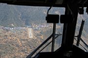
 Twin Otter approaching the airport
 Twin Otter on the runway
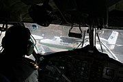 Twin Otters on the airfield
 The runway in 1999 before paving
avia.wikisort.org - Aerodrome
Tenzing–Hillary Airport (IATA: LUA, ICAO: VNLK), also known as Lukla Airport, is a domestic airport and altiport in the town of Lukla,[2] in Khumbu Pasanglhamu, Solukhumbu District, Province No. 1 of Nepal. It gained worldwide fame as it was rated the most dangerous airport in the world for more than 20 years by a program titled Most Extreme Airports, broadcast on The History Channel in 2010.[3]
Tenzing–Hillary Airport तेन्जिङ हिलारी विमानस्थल | |||||||||||
|---|---|---|---|---|---|---|---|---|---|---|---|
 | |||||||||||
| Summary | |||||||||||
| Airport type | Public | ||||||||||
| Owner | Government of Nepal | ||||||||||
| Operator | Civil Aviation Authority of Nepal | ||||||||||
| Serves | Lukla, Nepal | ||||||||||
| Hub for | |||||||||||
| Time zone | NST (UTC+05:45) | ||||||||||
| Elevation AMSL | 9,337 ft / 2,846 m | ||||||||||
| Coordinates | 27°41′16″N 086°43′53″E | ||||||||||
| Map | |||||||||||
 Tenzing–Hillary Airport Location of airport in Nepal | |||||||||||
| Runways | |||||||||||
| |||||||||||
The airport is popular because it is considered the starting point for treks towards Mount Everest Base Camp. There are daily flights between Lukla and Kathmandu during daylight hours in good weather. Although the flying distance is short, rain commonly occurs in Lukla while the sun is shining brightly in Kathmandu. High winds, cloud cover, and changing visibility often mean flights can be delayed or the airport closed.[3] The airport is contained within a chain-link fence and for security is patrolled by the Nepali armed police or civil police around the clock.
History
The airport was built in 1964 under the supervision of Sir Edmund Hillary, who originally intended to build the airport on flat farmlands. However, local farmers did not want to give up their land, so the airport was built at its current position. Hillary bought the land from local Sherpas for US$2,650 and involved them in building the facilities.[4] It has been said that Hillary was unhappy with the runway's soil resistance, and that his solution was to buy local liquor for the Sherpas and ask them to perform a foot-stomping dance to flatten the land that served as the runway.[5] The runway was not paved until 2001.[6]
In January 2008, the airport was renamed in honour of Sherpa Tenzing Norgay and Sir Edmund Hillary, the first people confirmed to have reached the summit of Mount Everest, and also to mark their efforts in the construction of this airport.[7]
Facilities

The airport's paved asphalt runway is accessible only to helicopters and small, fixed-wing, short-takeoff-and-landing aircraft such as the De Havilland Canada DHC-6 Twin Otter, Dornier 228, L-410 Turbolet and Pilatus PC-6 Turbo Porter. The runway is 527 m (1,729 ft) × 30 m (98 ft) with an 11.7% gradient.[1] The airport's elevation is 9,334 ft (2,845 m).[1] The airport is used for passenger flights and for transporting most of the building materials and cargo to Lukla and other towns and villages to the north of Lukla, as there is no road to this region.
In the early morning, the wind is usually from the north-east, changing to a south-west wind from mid to late morning due to the action of the sun on the mountains to the north of Lukla. The airport regularly closes from mid to late morning due to the strong south-west winds that create crosswind and/or tailwinds. Consequently, flights are usually scheduled for the early morning. Sudden loss of visibility preventing planes from landing under Visual flight rules (VFR) will result in the immediate closure of the airport with no warning. Although the airport is available throughout the year, visibility problems close the airport 50% of the time during the monsoon season with a consequent cancellation of 50% of flights. Due to the terrain and the low possibility of a safe go-around for a missed approach, there are no go-around procedures for this airport.[8][9][10]
Tenzing–Hillary Airport is frequently referred to as the most dangerous airport in the world.[3] Arriving and departing aircraft must use a single runway (06 for landing and 24 for takeoff). There is a low prospect of a successful go-around on short final approach due to the terrain. There is high terrain immediately beyond the northern end of the runway and a steeply angled drop at the southern end of the runway into the valley below.
Due to the difficulties of successfully landing at the airport, the Civil Aviation Authority of Nepal sets high standards, according to which only experienced pilots, who have completed at least 100 short-takeoff-and-landing (STOL) missions, have over one year of STOL experience in Nepal, and have completed ten flights into Lukla with a certified instructor pilot, are allowed to land at the airport.[11][12]
There are plans to construct five new helipads at the airport by July 2021[13] and expand the terminal and runway.[14]
Airlines and destinations

| Airlines | Destinations |
|---|---|
| Nepal Airlines | Kathmandu (suspended)[15][16] |
| Sita Air | Kathmandu[17] |
| Summit Air | Kathmandu[18] |
| Tara Air | Kathmandu[19] Charter: Phaplu |
- Notes
^1 Some destinations may be affected by COVID-19, therefore temporary suspensions are not distinguished as seasonal service.
The helicopter operator Air Dynasty offers helicopter operations out of its hub at Lukla Airport.[20]
Statistics
Passenger numbers
Annual passenger traffic at LUA airport.
See source Wikidata query.
| Passengers[21][22][23][24][25] | |
|---|---|
| 2003 | 70,959 |
| 2004 | |
| 2005 | |
| 2006 | |
| 2007 | |
| 2008 | |
| 2009 | |
| 2010 | |
| 2011 | |
| 2012 | |
| 2013 | |
| 2014 | |
| 2015 | |
| 2016 | |
| 2017 | |
| 2018 | |
| 2019 | |
Accidents and incidents


- On 15 October 1973, a Royal Nepal Airlines DHC-6 Twin Otter 300 (registration 9N-ABG) was damaged beyond repair on landing. The three crew and three passengers were unhurt.[26]
- On 9 June 1991, a Nepal Airlines DHC-6 Twin Otter 300 (registration 9N-ABA) from Kathmandu crashed at the airport while attempting to land following an unstabilized approach in bad weather. The three crew and fourteen passengers escaped with injuries.[27]
- On 26 September 1992, a Royal Air Nepal Harbin Yunshuji Y-12-II (registered 9N-ACI) faltered during takeoff and was damaged beyond repair. All twelve passengers and two crew survived.[28]
- On 25 May 2004, while on approach to the airport, a Yeti Airlines DHC-6 Twin Otter 300 (registration 9N-AFD) from Kathmandu crashed into Lamjura Hill in heavy clouds. No passengers were on board; all three crew members were killed. The Nepalese accident investigation committee concluded that the captain provided inaccurate information about his position to the Area Control Centre.[29]
- On 1 October 2004, on landing at the airport, a Sita Air Dornier 228 suffered a collapse of its nose gear and slid along the runway, blocking it once it had come to rest. The airport was closed for two days.[30]
- On 30 June 2005, a Gorkha Airlines Dornier 228 skidded off the runway while attempting to land. The nine passengers and three crew suffered minor injuries. The aircraft was reportedly withdrawn from service and written off after the accident.[31][32]
- On 8 October 2008, Yeti Airlines Flight 103, a DHC-6 Twin Otter 300 (registration 9N-AFE) crashed on final approach and caught fire, killing eighteen passengers and crew. The aircraft's captain was the only survivor. Video of the incident showed inclement weather at the time of the incident.[33]
- On 12 October 2010, a Sita Air Dornier 228 (registration 9N-AHB) lost braking control and struck the wall-end of the runway during landing. All passengers and crew escaped injury; the aircraft's nose was damaged.[34]
- On 26 September 2013, an Air Dynasty helicopter (registration 9N-AEX) crashed when the rear rotor touched the barbed wire of the compound wall at the airport. All three passengers and the captain survived.[35]
- On 27 May 2017, Summit Air Flight 409, performing a freight flight on a Let L-410 from Kathmandu to Lukla (Nepal) with three crew, was on final approach to Lukla's runway 06 at about 14:04L (08:19Z) with poor visibility when the aircraft lost altitude and touched a tree short of the runway before contacting ground about 3 metres/10 feet below the runway level. The aircraft slid down the slope before coming to a rest about 200 metres below the runway level. The captain was killed and the first officer, Shrijan Manandhar, died in hospital almost eight hours later. The third crew member received injuries and was evacuated to Kathmandu the following day after the weather had cleared.[36][37][38]
- On 14 April 2019, at 9:10 am a Summit Air Let L-410 Turbolet aircraft, registration 9N-AMH, with no passengers on board veered right and departed the runway on take-off from Lukla Airport and struck a Manang Air Eurocopter AS 350B3e helicopter registration 9N-ALC on the helipad 30 to 50 metres from the runway, destroying both the plane and the helicopter. A second helicopter, Shree Airlines Eurocopter AS 350 registered 9N-ALK, sustained little or no damage. The three reported fatalities were the co-pilot of the plane, a police officer on airport security duty who died in the crash and a second police officer who was critically injured and airlifted to Kathmandu, where he died in hospital. Among the four reported injured include the pilot of the plane and a Manang Air helicopter pilot, who were injured and flown to a hospital in Kathmandu, where they were reported to be out of danger.[39][40][41][42]
Gallery


See also
References
- "National Airports Plan – Current Situation and Diagnostic" (PDF). Civil Aviation Authority of Nepal. Archived from the original (PDF) on 2 April 2015. Retrieved 7 March 2015.
- Airport information for Lukla, Nepal – Tenzing–Hillary Airport (VNLK / LUA) at Great Circle Mapper.
- "Most Extreme Airports". History Specials. Season 1. Episode 104. The History Channel. 26 August 2010.
- Ibišbegović, Denis; Vesić, Zoran; Dikić, Nenad (2012). Inspirisani trenutkom: put za Everest bazni kamp. Belgrade: Nenad Dikić. pp. 49–50. ISBN 9788691549107. Retrieved 30 October 2017.
- "Nepal quake tough test for 'world's most dangerous airport'". The Himalayan Times. Retrieved 30 October 2017.
- "This Is the World's Most Dangerous Airport". CN Traveler. Retrieved 30 October 2017.
- "Nepal to name Everest airport after Edmund Hillary and Tenzing Norgay". International Herald Tribune. 15 January 2008. Archived from the original on 12 February 2008. Retrieved 27 April 2010.
- "National Airports Plan – Current Situation and Diagnostic, Draft" (PDF). Civil Aviation Nepal. Civil Aviation Authority of Nepal, September 2012. Retrieved 21 April 2019.
- "More than luck in Lukla". Nepali Times. 4 January 2019. Retrieved 1 April 2019.
- "No go-around". The Katmandu Post. 22 July 2017. Retrieved 1 April 2019.
- "Flight Operations Requirements Aeroplane (Appendix 9)" (PDF). Civil Aviation Authority of Nepal. Retrieved 30 October 2017.
- "Incident: Nepal Airlines DHC6 at Solukhumbu on Apr 19th 2010, hard landing". The Aviation Herald. Retrieved 30 October 2017.
- "Aviation Nepal - Lukla Heliport Update".
{{cite web}}: CS1 maint: url-status (link) - "New Helipad to be constructed at Lukla airport". Aviation Nepal. 28 October 2018. Retrieved 1 April 2019.
- "Lukla flight operation from Ramechhap initiates today". Aviation Nepal. Retrieved 1 April 2019.
- "Domestic airline companies issue travel alert for passengers". The Himalayan Times. Retrieved 1 April 2019.
- "Flight Schedule". Sita Air. Retrieved 1 May 2018.
- "Flight Schedule". Summit Air. Retrieved 1 April 2019.
- "Flight Schedule". Tara Air. Retrieved 1 October 2018.
- "Air dynasty operating service from three bases around the country". Aviation Nepal. Retrieved 1 November 2017.
- "Civil Aviation Report 2009-2010" (PDF). Civil Aviation Authority of Nepal. Archived from the original (PDF) on 29 September 2011. Retrieved 1 June 2018.
- "Civil Aviation Report 2011–2012" (PDF). Civil Aviation Authority of Nepal. Archived from the original (PDF) on 1 November 2012. Retrieved 1 June 2018.
- "Civil Aviation Report 2017" (PDF). Civil Aviation Authority of Nepal. Archived from the original (PDF) on 18 June 2018. Retrieved 1 June 2018.
- "Civil Aviation Report Annual 2018" (PDF). Civil Aviation Authority of Nepal. Retrieved 1 July 2019.
- "CAAN Report 2019–2020" (PDF). Civil Aviation Authority of Nepal. Retrieved 1 January 2021.
- Aviation Safety Network. Retrieved 18 November 2006.
- "ASN Aircraft accident de Havilland Canada DHC-6 Twin Otter 300 9N-ABA Lukla Airport (LUA)". Retrieved 23 June 2011.
- "ASN Aircraft accident Harbin Yunshuji Y-12-II 9N-ACI Lukla Airport (LUA)". Aviation-safety.net. 26 September 1992. Retrieved 9 February 2012.
- Aviation Safety Network. Retrieved 18 November 2006.
- "Lukla airport still closed". Nepali Times. Retrieved 1 November 2020.
- Airline Industry Information, 30 June 2005.
- Aviation Safety Network. Retrieved 18 November 2006.
- BBC News. Retrieved 8 October 2008.
- Air Crash Observer "Archived copy". Archived from the original on 7 July 2011. Retrieved 7 July 2011.
{{cite web}}: CS1 maint: archived copy as title (link). Retrieved 15 December 2010 - "Chopper crashes in Lukla, minor injuries". Nepalnews.com. 26 September 2013. Archived from the original on 3 March 2016.
- "Accident: Summit L410 at Lukla on May 27th 2017, contacted trees and impacted ground before runway". The Aviation Herald. 27 May 2017. Retrieved 28 May 2017.
- "Lukla air crash toll reaches 2 as co-pilot dies for want of treatment". The Himalayan Times. 28 May 2017. Retrieved 30 May 2017.
- "Kiwi 'heroes' in dramatic Mt Everest rescue after cargo plane slams into mountain". New Zealand Herald. 29 May 2017. Retrieved 18 June 2017.
- Pokhre, Rajan (14 April 2019). "Three killed, four injured in Lukla crash". No. 14 April 2019. The Himalayan Times. Retrieved 14 April 2019.
- Prasain, Sangam (14 April 2019). "At least three killed in Summit Air plane crash at Lukla airport". No. 14 April 2019. The Kathmandu Post. Retrieved 14 April 2019.
- "Lukla plane–chopper collision kills 3". No. 14 April 2019. Nepali Times. 14 April 2019. Retrieved 14 April 2019.
- "Developing story". Aviation Safety Network. Flight Safety Foundation. Retrieved 14 April 2019.
External links
![]() Media related to Lukla Airport at Wikimedia Commons
Media related to Lukla Airport at Wikimedia Commons
- Video of operations at the Lukla airport from YouTube
- Important message Regarding Flight to Lukla
- Accident history for LUA / VNLK at Aviation Safety Network
- Photo of aircraft departing Lukla from Airliners.net
- "Most Dangerous airport in the world" Lukla Airport video
- "The World's Most Dangerous Airport" from forbes.com
- Landing at Lukla Airport Lukla airport article
| International | |||||
|---|---|---|---|---|---|
| Domestic |
| ||||
| Under construction |
| ||||
| Defunct | |||||
На других языках
[de] Flughafen Lukla
Der Flughafen Lukla (IATA-Code: LUA, ICAO-Code: VNLK, offiziell: Tenzing-Hillary Airport[1][2]) in Lukla ist ein Flugplatz für STOL-Flugzeuge in Nepal. Er ist in einem halbstündigen Flug von Kathmandu aus erreichbar und dient heute den meisten Touristen, die die Everest-Region bereisen, als Ausgangspunkt vor allem für den Mount Everest Trek.- [en] Tenzing–Hillary Airport
[fr] Aéroport Tenzing-Hillary
@media all and (max-width:720px){body.skin-minerva .mw-parser-output *[class*="infobox"] table{display:table}body.skin-minerva .mw-parser-output *[class*="infobox"] caption{display:table-caption}}[it] Aeroporto di Lukla
L'Aeroporto di Lukla (in nepalese: तेन्जिङ हिलारी विमानस्थल) è un altiporto del Nepal nordorientale, situato all'altitudine di 2 846 m s.l.m. Serve la cittadina himalayana di Lukla, nel distretto di Solukhumbu.[ru] Аэропорт имени Тенцинга и Хиллари
Аэропорт имени Тенцинга и Хиллари (ИАТА: LUA, ИКАО: VNLK), ранее до 2008 года — аэропорт Лукла — небольшой аэропорт в городе Лукла в регионе Кхумбу, район Солукхумбу, 1-я провинция в восточной части Непала. Был признан СМИ как один из самых опасных аэропортов мира[1][2][3].Текст в блоке "Читать" взят с сайта "Википедия" и доступен по лицензии Creative Commons Attribution-ShareAlike; в отдельных случаях могут действовать дополнительные условия.
Другой контент может иметь иную лицензию. Перед использованием материалов сайта WikiSort.org внимательно изучите правила лицензирования конкретных элементов наполнения сайта.
Другой контент может иметь иную лицензию. Перед использованием материалов сайта WikiSort.org внимательно изучите правила лицензирования конкретных элементов наполнения сайта.
2019-2026
WikiSort.org - проект по пересортировке и дополнению контента Википедии
WikiSort.org - проект по пересортировке и дополнению контента Википедии