avia.wikisort.org - Aerodrome
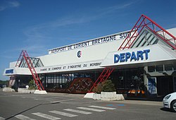
Lorient South Brittany Airport or Aéroport de Lorient Bretagne Sud (IATA: LRT, ICAO: LFRH), also known as Lorient-Lann-Bihoué Airport, is the airport serving the city of Lorient. It is situated 5 km west-northwest of Lorient,[1] a commune of the Morbihan département in the Brittany region of France.
Lorient South Brittany Airport Aéroport de Lorient Bretagne Sud | |||||||||||||||
|---|---|---|---|---|---|---|---|---|---|---|---|---|---|---|---|
 | |||||||||||||||
| Summary | |||||||||||||||
| Airport type | Joint mil-civ airfield | ||||||||||||||
| Operator | Morbihan Chamber of Commerce and Industry; Fleet Air Arm | ||||||||||||||
| Serves | Lorient, France | ||||||||||||||
| Elevation AMSL | 160 ft / 49 m | ||||||||||||||
| Coordinates | 47°45′38″N 03°26′24″W | ||||||||||||||
| Website | www | ||||||||||||||
| Maps | |||||||||||||||
 The Brittany region within France | |||||||||||||||
 LFRH Location of the airport in Brittany | |||||||||||||||
| Runways | |||||||||||||||
| |||||||||||||||
Airlines and destinations
The following airline operates regular scheduled and charter flights at Lorient Airport:
| Airlines | Destinations |
|---|---|
| APG Airlines | Toulouse[3] |
Statistics
Military use
The airport is comparatively large, 3 km by 3 km, which is due to its being built during the Second World War to support German submarine operations from the nearby base in Lorient.
It is also known as Lann Bihoue Naval Air Base (Base Aéronavale de Lann Bihoué) and is one of the French Naval Aviation bases, currently hosting:
- Two combat squadrons (flottilles) (11F, 17F) equipped with Dassault Rafale M aircraft, suitable to fly naval and land combat and recce missions and nuclear deterrence missions
- One interception squadron (12F) equipped with Dassault Rafale M aircraft, assuring air superiority
- One airborne radar squadron (4F) equipped with Grumman E-2C Hawkeye aircraft, to secure the skies over the fleet and to control air-traffic
- One training/mission preparation unit
These units also form the airwing which is assigned to the aircraft carrier Charles de Gaulle.
Accidents
- On July 30, 1998, Proteus Airlines Flight 706 collided with a Cessna after flying off-course on approach to the airport, leading to the deaths of the people on both planes.
References
- LFRH – LORIENT LANN BIHOUÉ. AIP from French Service d'information aéronautique, effective 3 November 2022.
- Lorient South Brittany Airport (official site)
- "APG AIRLINES". APG Inc. Retrieved 7 September 2018.
External links
- Base Aeronavale Lann Bihoue
- Lorient South Brittany Airport (official site) (in English)
- Aéroport de Lorient-Bretagne Sud (Union des Aéroports Français) (in French)
- Accident history for Lorient-Lann Bihoué Airport (LRT) at Aviation Safety Network
На других языках
[de] Flughafen Lorient Bretagne Sud
Der Flughafen Lorient Bretagne Sud (IATA-Code LRT, ICAO-Code LFRH), üblicherweise Flughafen Lorient-Lann-Bihoué benannt, ist der Flughafen der westfranzösischen Stadt Lorient und liegt in der französischen Kommune Ploemeur im Département Morbihan, rund zwölf Kilometer westlich von Lorient. Er wird sowohl militärisch als auch zivil genutzt. Der zivile Teil des Flughafens wird von der IHK Morbihan verwaltet. Der mit 800 ha flächenmäßig größte Militärflugplatz Europas wird von der Aéronavale als Base aéronautique navale de Lann-Bihoué bezeichnet.- [en] Lorient South Brittany Airport
[fr] Aéroport de Lorient-Bretagne-Sud
L’aéroport de Lorient Bretagne Sud (code IATA : LRT • code OACI : LFRH), auparavant dénommé aéroport de Lorient Lann-Bihoué, est un aéroport à usage mixte, militaire et civil, situé sur la commune de Plœmeur à 9 km à l'ouest de Lorient, département du Morbihan région Bretagne.Другой контент может иметь иную лицензию. Перед использованием материалов сайта WikiSort.org внимательно изучите правила лицензирования конкретных элементов наполнения сайта.
WikiSort.org - проект по пересортировке и дополнению контента Википедии