 Threshold of runway 16 (now 15)
 Threshold of runway 34 (now 33)
 Overhead Kimmirut airport
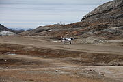 Twin Otter landing runway 34 (now 33)
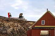 Twin Otter just landing on runway 34 (now 33)
avia.wikisort.org - Aerodrome
Kimmirut Airport (IATA: YLC, ICAO: CYLC) is located at Kimmirut, Nunavut, Canada, and is operated by the Government of Nunavut. Unlike most airports in Nunavut, it uses magnetic headings for the runway rather than true headings.
Kimmirut Airport | |||||||||||
|---|---|---|---|---|---|---|---|---|---|---|---|
 | |||||||||||
| Summary | |||||||||||
| Airport type | Public | ||||||||||
| Operator | Government of Nunavut | ||||||||||
| Location | Kimmirut | ||||||||||
| Time zone | EST (UTC−05:00) | ||||||||||
| • Summer (DST) | EDT (UTC−04:00) | ||||||||||
| Elevation AMSL | 169 ft / 52 m | ||||||||||
| Coordinates | 62°50′53″N 069°52′38″W | ||||||||||
| Map | |||||||||||
 CYLC Location in Nunavut  CYLC CYLC (Canada) | |||||||||||
| Runways | |||||||||||
| |||||||||||
| Statistics (2010) | |||||||||||
| |||||||||||
At 1,899 ft (579 m) the Kimmirut airstrip is the second shortest in Nunavut. Formerly Arctic Bay Airport at 1,500 ft (457 m) was the shortest, but in 2010 the runway was extended to 3,935 ft (1,199 m).[1]
The runway at Grise Fiord Airport is just slightly shorter than Kimmirut at 1,675 ft (511 m).[1] The length of the runway and challenging terrain at both Kimmirut and Grise Fiord limit the type of aircraft that can service those communities. Currently, both are served by airlines operating Twin Otter aircraft.
Airlines and destinations
| Airlines | Destinations |
|---|---|
| Canadian North | Iqaluit[3] |
Kimmirut Airport


References
- Canada Flight Supplement. Effective 0901Z 16 July 2020 to 0901Z 10 September 2020.
- Total aircraft movements by class of operation
- Full network schedule
- Aeronautical Information Manual Transport Canada publication TP 14371E
- Designated Airspace Handbook, Transport Canada
External links
- Past three hours METARs, SPECI and current TAFs for Kimmirut Airport from Nav Canada as available.
Airports in Canada | |
|---|---|
| By name | |
| By location indicator | |
| By province/territory | |
| By area | |
| National Airports System | |
| Related | |
| |
This article about an airport in Nunavut is a stub. You can help Wikipedia by expanding it. |
На других языках
- [en] Kimmirut Airport
[es] Aeropuerto de Kimmirut
El Aeropuerto de Kimmirut (en inglés: Kimmirut Airport) (IATA: YLC, OACI: CYLC) está ubicado en Kimmirut, Nunavut, Canadá y es operado por el gobierno de Nunavut. Con diferencia a la mayoría de los aeropuerto de Nunavut, este aeropuerto utiliza direccionales magnéticas en lugar de direccionales verdaderas. Kimmirut, Iqaluit, y Sanikiluaq son los únicos aeropuertos de Nunavut donde las direccionales de las pistas de aterrizaje son dados en grados magnéticos. Todos los otros aeropuertos de Nunavut dan las direccionales en grados verdaderos.[fr] Aéroport de Kimmirut
@media all and (max-width:720px){body.skin-minerva .mw-parser-output *[class*="infobox"] table{display:table}body.skin-minerva .mw-parser-output *[class*="infobox"] caption{display:table-caption}}Текст в блоке "Читать" взят с сайта "Википедия" и доступен по лицензии Creative Commons Attribution-ShareAlike; в отдельных случаях могут действовать дополнительные условия.
Другой контент может иметь иную лицензию. Перед использованием материалов сайта WikiSort.org внимательно изучите правила лицензирования конкретных элементов наполнения сайта.
Другой контент может иметь иную лицензию. Перед использованием материалов сайта WikiSort.org внимательно изучите правила лицензирования конкретных элементов наполнения сайта.
2019-2026
WikiSort.org - проект по пересортировке и дополнению контента Википедии
WikiSort.org - проект по пересортировке и дополнению контента Википедии