avia.wikisort.org - Aerodrome
Sebba Airport (IATA: XSE, ICAO: DFES) is an airport serving the village of Sebba in the Yagha Province, part of the Sahel Region of Burkina Faso.
Sebba Airport | |||||||||||
|---|---|---|---|---|---|---|---|---|---|---|---|
| |||||||||||
| Summary | |||||||||||
| Serves | Sebba, Yagha Province, Sahel Region, Burkina Faso | ||||||||||
| Location | |||||||||||
| Elevation AMSL | 270 m / 886 ft | ||||||||||
| Coordinates | 13°27′24″N 0°30′10″E | ||||||||||
| Maps | |||||||||||
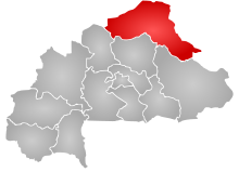 Sahel Region in Burkina Faso | |||||||||||
 XSE Location of the airport in Burkina Faso | |||||||||||
| Runways | |||||||||||
| |||||||||||
The runway is unmarked and its length is estimated.
See also
References
- Bing Maps - Sebba
- Airport record for Sebba Airport at Landings.com. Retrieved 2013-08-22
- Google (2013-08-22). "location of Sebba Airport" (Map). Google Maps. Google. Retrieved 2013-08-22.
- Airport information for Sebba Airport at Transport Search website.
External links
- Airport record for Sebba Airport at Landings.com
This article about an airport in Burkina Faso is a stub. You can help Wikipedia by expanding it. |
На других языках
- [en] Sebba Airport
[fr] Aérodrome de Sebba
L'aérodrome de Sebba est un aérodrome desservant le village de Sebba dans la province de Yagha, qui fait partie de la région du Sahel au Burkina Faso.Текст в блоке "Читать" взят с сайта "Википедия" и доступен по лицензии Creative Commons Attribution-ShareAlike; в отдельных случаях могут действовать дополнительные условия.
Другой контент может иметь иную лицензию. Перед использованием материалов сайта WikiSort.org внимательно изучите правила лицензирования конкретных элементов наполнения сайта.
Другой контент может иметь иную лицензию. Перед использованием материалов сайта WikiSort.org внимательно изучите правила лицензирования конкретных элементов наполнения сайта.
2019-2025
WikiSort.org - проект по пересортировке и дополнению контента Википедии
WikiSort.org - проект по пересортировке и дополнению контента Википедии