avia.wikisort.org - Aérodrome
L'aéroport de Paro (code IATA : PBH • code OACI : VQPR) est l'unique aéroport international du Bhoutan. Il se situe à 6 kilomètres de la ville de Paro, à une altitude de 2 235 mètres.
| Aéroport international de Paro སྤ་རོ་གནམ་ཐང༌། | ||||||||||
 Vue aérienne de l’aéroport international de Paro le 5 septembre 2006. | ||||||||||
| Localisation | ||||||||||
|---|---|---|---|---|---|---|---|---|---|---|
| Pays | ||||||||||
| Ville | Paro | |||||||||
| Coordonnées | 27° 24′ 14″ nord, 89° 25′ 29″ est | |||||||||
| Altitude | 2 235 m (7 332 ft) | |||||||||
| Informations aéronautiques | ||||||||||
| Code IATA | PBH | |||||||||
| Code OACI | VQPR | |||||||||
| Type d'aéroport | Civil | |||||||||
|
||||||||||
| Géolocalisation sur la carte : Bhoutan
| ||||||||||
| modifier |
||||||||||

Caractéristiques
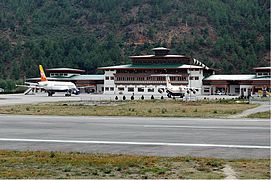
Il possède une piste, un terminal passager ainsi qu'un terminal cargo. On y trouve quatre bureaux d'enregistrement et une porte d'embarquement.
L'aéroport étant entouré de montagnes culminant à 5 490 mètres et longé par la Paro Chhu, l'atterrissage y est considéré comme un des plus grands défis pour les pilotes. La piste ne fait que 30 mètres de large au lieu des 45 m habituels pour seulement 2 000 m de long.
Le système de guidage au sol des aéronefs est obsolète de sorte que l'approche doit se faire entièrement en pilotage manuel. Après une descente et un cheminement entre les montagnes pour suivre la topographie de la vallée, la piste n'est finalement visible qu'après avoir contourné une dernière crête. Selon Travel & Leisure[Quand ?], il n'y a que huit pilotes bhoutanais certifiés pour y atterrir. Selon l'émission de la chaîne France 5 Atterrissage imminent de 2016[1], il n'y a que 26 pilotes certifiés dans le monde pour y atterrir.
La compagnie nationale bhoutanaise Druk Air y a établi sa plate-forme de correspondance.
En 2002, l'aéroport a traité 37 151 passagers et 90 983 tonnes de marchandises[réf. nécessaire].
Situation

Compagnies aériennes et destinations
| Compagnies | Destinations |
|---|---|
| Bangkok-Suvarnabhumi, Delhi-Indira Gandhi, Bathpalathang (suspendu), Katmandou-Tribhuvan, Calcutta-N. S. C. Bose, Yongphulla (suspendu) | |
| Charter : Katmandou-Tribhuvan | |
| Bagdogra, Bangkok-Suvarnabhumi, Delhi-Indira Gandhi, Dacca-Shah Jalal, Gelephu, Guwāhāti, Bathpalathang, Katmandou-Tribhuvan, Calcutta-N. S. C. Bose, Bombay-Chhatrapati-Shivaji (En saison), Singapour-Changi, Yongphulla (suspendu) |
Édité le 09/03/2018
Galerie
 L'aéroport international du Bhoutan en 2005.
 L'aéroport de Paro en 2006.
 Intérieur de l'aéroport de Paro en 2008.


Voir aussi
Notes et références
- « Attachez vos ceintures S01E02 : Atterrissage imminent » (consulté le )
- (en) Jim Liu, « Bhutan Airlines adds Gaya service in W17 », Routes online, (lire en ligne, consulté le )
 Portail de l’aéronautique
  Portail du Bhoutan
На других языках
[de] Flughafen Paro
Der Flughafen Paro (IATA-Code: PBH; ICAO-Code: VQPR; Dzongkha: སྤ་རོ་གནམ་ཐང༌) ist ein Flughafen in Bhutan und zugleich der einzige internationale des Landes, etwa 65 Kilometer Fahrtstrecke westlich der Hauptstadt Thimphu gelegen.[2] Paro Airport befindet sich auf einer Höhe von 2236 m in einem tiefen Tal (Paro-Tal), circa sechs Kilometer südöstlich von Paro.[en] Paro International Airport
Paro International Airport (Dzongkha: སྤ་རོ་གནམ་ཐང༌།, romanized: paro gnam thang) (IATA: PBH, ICAO: VQPR) is the sole international airport of the four airports in Bhutan. It is 6 km (3.7 mi; 3.2 nmi) from Paro in a deep valley on the bank of the river Paro Chhu. With surrounding peaks as high as 5,500 m (18,000 ft), it is considered one of the world's most challenging airports,[2] and fewer than two dozen pilots are certified to land at the airport.[3][4][es] Aeropuerto Internacional de Paro
El Aeropuerto Internacional de Paro (IATA: PBH, OACI: VQPR) es el único aeropuerto internacional de los 4 aeropuertos que tiene Bután, situado a 6 km de la ciudad de Paro y 48 km de la capital del país, Timbu. Se encuentra a 2237 m de altitud en un amplio valle junto al curso del río Paro Chhu. Con montañas de hasta 5480 m a sus alrededores, está considerado uno de los aeropuertos más complicados y peligrosos del mundo.[2] Los vuelos en Paro sólo están permitidos cuando se cumplen las condiciones de aproximación visual y sólo se abre desde el amanecer hasta el ocaso.[3] Según Travel & Leisure, sólo ocho pilotos en el mundo están certificados para aterrizar en el aeropuerto.[4]- [fr] Aéroport international de Paro
[it] Aeroporto Internazionale di Paro
L'Aeroporto Internazionale di Paro[2] (IATA: PBH, ICAO: VQPR) è uno dei quattro aeroporti del Bhutan, situato a 6 km a sud della città di Paro, capoluogo dell'omonimo distretto, lungo l'arteria stradale che collega Paro a Raga e da lì alla capitale Thimphu, che invece sorge a 54 km dall'impianto. Lo scalo sorge sulle rive del Paro Chhu ed è il più importante nonché l'unico aeroporto internazionale del Paese asiatico. Circondato da picchi alti fino a 5.500 m, è considerato uno degli aeroporti più difficili e pericolosi del mondo,[3] e solo un numero selezionato di piloti ha le certificazioni e i permessi necessari per atterrare sulla sua pista.[4][ru] Паро (аэропорт)
Аэропорт Паро (дзонг-кэ སྤ་རོ་གནམ་ཐང༌།, вайли paro gnam thang) (ИАТА: PBH, ИКАО: VQPR) — один из четырёх аэропортов в Королевстве Бутан, имеет единственную ВПП с асфальтовым покрытием. Расположенный в шести километрах от города Паро на высоте более двух тысяч метров в тесной долине реки Паро, аэропорт окружён вершинами-пятитысячниками, поэтому считается одним из сложнейших на планете[2], и менее двух десятков пилотов сертифицированы для посадки в аэропорту[3][4]. Помимо Паро в Бутане работает ещё три аэропорта — аэропорт Йонгпхулла в городе Ташиганг, аэропорт Бартхпалатханг в непосредственной близости от города Джакар, а также Гелепху. Планируется также создание сети малых аэропортов во всей стране.Другой контент может иметь иную лицензию. Перед использованием материалов сайта WikiSort.org внимательно изучите правила лицензирования конкретных элементов наполнения сайта.
WikiSort.org - проект по пересортировке и дополнению контента Википедии